In our 5 Easiest Top 100 Mountain Hikes article we selected five of the easiest 百名山 (Top 100 Mountains) with routes that even complete beginners could hike. Now, we have selected 5 more mountains as next steps.


What are the top 100 mountains?

Japan’s top 100 mountains (百名山) come from a book written in 1969 by the famous Japanese hiker Kyuya Fukada. Fukuda is said to have climbed hundreds of peaks and chosen his top 100 based on their grace, history, and individuality. Since then, hikers across Japan have made it their mission to hike all 100 in their lifetimes, and people often list how many they have conquered on their Instagram profiles. Nearly all mountains on the top 100 list are over 1500m, which may be daunting to new hikers. There is no need to be intimidated, though; the distance you actually need to hike on many of them is pretty low, especially if you use the ropeway!


大台ヶ原山

Height: 1695m

Elevation Gain: 476m

八甲田山

Height: 1585m

Elevation Gain: 479m

霧ヶ峰

Height: 1925m

Elevation Gain: 480m

草津白根山

Height: 2171m

Elevation Gain: 509m

月山

Height: 1984m

Elevation Gain: 584m

大台ヶ原山

Odaigaharayama | Nara


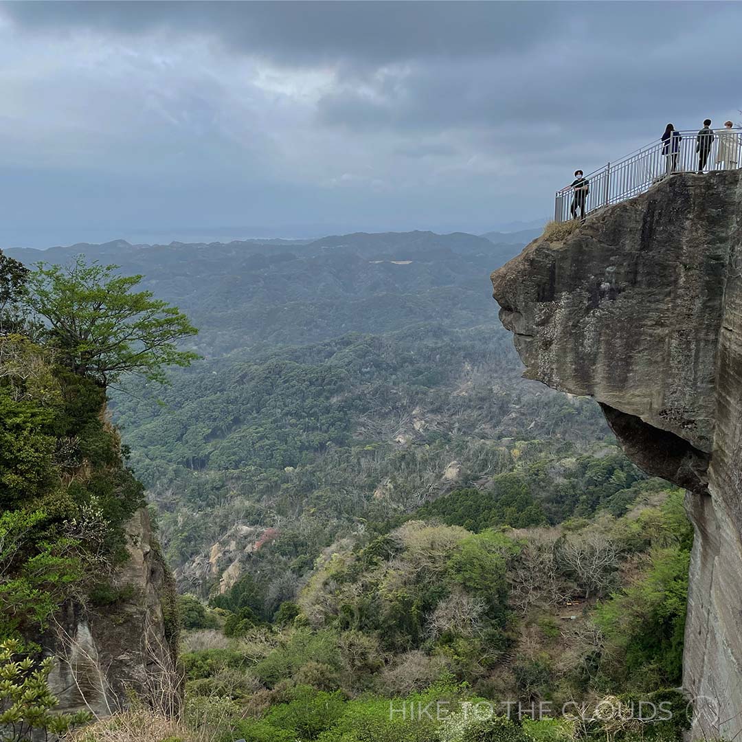
Odaigahara Plateau has the highest amount of rainfall per year in Honshu. Thanks to this, the mountain and surrounding forests and valleys support a thriving ecosystem. In fact, the nearby Osugidani is ranked one of Japan’s top 3 valleys for beauty and is part of the World Network of Biosphere Reserves. Our guide takes you through the equally luscious Shiokaradani Valley, past the famous view point Daijyakuratenboudai and up to the highest peak, Mount Hidegatake (1695m). From the summit, it is possible to see panoramic views over the Omine Mountains and the Kumano-nada Sea.

Hiking Route


Starting from the carpark follow signs towards Shioharadani Valley (シオカラ谷) and Daijyagura (大蛇嵓). After passing the Mountain House (Yama No Ie) Lodge (山の家ロッジ), the trail will begin to slope down into the valley.

After reaching the valley, you will need to cross a bridge; once across, you will come to a split in the trail. Take the path towards Daijyagura (大蛇嵓).

When you are finished taking pictures of the views at Daijyagura, head back to the fork. This time take the other route towards the green fields of Ushiishigahara (牛石ヶ原). This area is well known for its large bunches of deer.

Head down a little further to reach Owasetsuji (尾鷲辻). There is a fork onto an escape route which heads back to the carpark, head right and up towards Masaki ga Hara (正木ヶ原). From here, jump onto the wooden walkway, which leads all the way up to the summit.

After taking a victory picture of you conquering a new Top 100 Mountain, go in glory back to the carpark.

Odaigahara Car Park (大台ヶ原駐車場) ~ (30m) ~ Shiokaradani Valley (シオカラ谷) ~ (1h 15m) ~ Daijyaguratenboudai (大蛇嵓展望台) ~ (25m) ~ Ushi ishi ga hara (牛石ヶ原) ~ (15m) ~ Owasetsuji (尾鷲辻) ~ (15m) ~ Masaki ga hara (正木ヶ原) ~ (45m) ~ Mount Hidegatake (日出ヶ岳) ~ (35m) ~ Odaigahara Car Park (大台ヶ原駐車場)


Access

By Train and Bus: The nearest train station is Yamatokamiichi Station (大和上市駅) on the Kintetsuyoshino line (近鉄吉野線). From there take the Nara Kotsu Bus 奈良交通バス (1h 51m) to Odaigahara (大台ヶ原). The bus only runs once a day on weekdays and twice a day on weekends and holidays. If you miss the bus, a taxi will take around 1h 30m and cost about 1 man 5 sen. The bus service runs between the end of April, and the end of November as the Odaigahara Driveway (road 40) is closed through winter due to heavy snow.

By Car (recommened): To get to Odaigahara Carpark, take the..., leave the motorway at the ...IC, from there take national roads 165, 24, 164, prefectural road 40 (大台ケ原ドライブウエイ) for around 78km.
The carpark is free and can hold up to 200 cars.


Helpful phone numbers
Nara Kotsu Bus: 0742-20-3100
Nara Kintetsu Taxi: 0746-32-2916
Local Tourist Information: 0746-8-2-0001

Helpful Websites
Nara Kotsu Bus Timetable(English Website)
Kamikitayama Village Tourism Website (Japanese) including route map and access information.


八甲田山

Mount Hakkoda | Aomori


Hop on the 10-minute, 2.5 km ropeway to see magnificent views in all seasons. On a clear day, there are views over the Tsugaru plains, Mutsu Bay, and even as far as Hokkaido. Peak season is between September and October, when the forests look most vibrant with Autumn oranges and reds of the Japanese maple and rowan trees. The variety of trails makes this an incredible mountain for beginner hikers. Our guide below has provided directions for a 4h 35m hike. However, if you are not yet at that level, there is also a much shorter flat 30-minute walking path to try.


Hiking Route 1


Take the Hakkoda Ropeway up to the Sancho Koen Station. Enjoy the 10 minutes of beautiful views as you travel 2.5km. From the ropeway station follow signs for around 30 minutes to Kamikenashitaibunki (上毛無岱分岐). From there, you will start a 1-hour gentle ascent up to Akakuradake (赤倉岳). The path between here and your next point (Odakeanbuhinan Hut 大岳鞍部避難小屋) is full of PUDs (pointless ups and downs). Once you have passed the hut, you will head to the Hakkoda summit (八甲田大岳 Hakkodaodake). It is a little steep but should only take around 30 minutes. As a reward, you will be treated to breathtaking panoramic views and the knowledge that you have conquered another Top 100 Mountain (百名山). From here you will head back down the way you came to Odakaanbuhinan Hut (大岳鞍部避難小屋). From the hut turn west (left) towards Kamikenashitaitenboudai (上毛無岱展望台) and further down to Shimokenashitaitenboudai (毛無岱展望台). Carry on for another 50 minutes to reach your final destination Sukayu Onsen (酸ヶ湯温泉).

Sancho Koen Station (山頂公園駅) ~ (30m) ~ Kamikenashitaibunki (上毛無岱分岐) ~ (1h) ~ Akakuradake (赤倉岳) ~ (20m) ~ Odakeanbuhinan Hut (大岳鞍部避難小屋) ~ (30m) ~ Hakkoda odake (八甲田大岳) ~ (20m) ~ Odakeanbuhinan Hut (大岳鞍部避難小屋) ~ (40m) ~ Kamikenashitaitenboudai (上毛無岱展望台) ~ (25m) ~ Shimokenashitaitenboudai (毛無岱展望台) ~ (50m) ~ Sukayu Onsen (酸ヶ湯温泉)


Hiking Route 2


From the onsen carpark, head up and right towards the hut. It will take about 1h 30m to reach the hut where there are toilets. After passing the hut, it is 50 minutes to the peak. After spending time admiring the view at the summit, you have 2 options to come down. Option 1, head back down the way you came, or Option 2 head down to Odakaanbuhinan Hut (大岳鞍部避難小屋) on the other side. From the hut turn west (left) towards Kamikenashitaitenboudai (上毛無岱展望台) and further down to Shimokenashitaitenboudai (毛無岱展望台). Carry on for another 50 minutes to reach your Sukayu Onsen (酸ヶ湯温泉) again.

Upper-Begginner Short Route (4h 10m)
Sukayu Onsen (酸ヶ湯温泉) ~ (1h 30m) ~ Hut (ヒュッテ) ~ (50m) ~ Hakkoda odake (八甲田大岳) ~ (40m) ~ Hut (ヒュッテ) ~ (1h 10m) ~ Sukayu Onsen (酸ヶ湯温泉)

Upper-Begginner Long Route (4h 45m)
Sukayu Onsen (酸ヶ湯温泉) ~ (1h 30m) ~ Hut (ヒュッテ) ~ (50m) ~ Hakkoda odake (八甲田大岳) ~ (20m) ~ Odakeanbuhinan Hut (大岳鞍部避難小屋) ~ (40m) ~ Kamikenashitaitenboudai (上毛無岱展望台) ~ (25m) ~ Shimokenashitaitenboudai (毛無岱展望台) ~ (50m) ~ Sukayu Onsen (酸ヶ湯温泉)


Access

By Train and Bus:
(recommended for Hiking Route 1)

On the way: Take a train to Shin Aomori Station (新青森駅). From Tokyo area it is possible to get the Hayabusa 43 Shinkansen (はやぶさ 43号) from Omiya Station (大宮) which takes around 2h 45m. Once you have arrived, take the JRバス東北 (about 55m) to the ropeway.
Return: From Sukayu Onsen (酸ヶ湯温泉) take the JRバス東北 (around 1h 10m) back to Shin Aomori Station (新青森駅).

By Car:
(Hiking Route 1)

The ropeway carpark is free and has 300 spaces available. On the way back you will need to take the bus from Sukayu Onsen (酸ヶ湯温泉) back to the Ropeway Station.

By Car:
(Hiking Route 2)

Park in the Sukayu Onsen (酸ヶ湯温泉) car park.

Helpful phone numbers
JR Bus Tohoku: 017-773-5722
Hakkoda Ropeway: 017-738-0343
Taxi: 017-739-5029
Aomori Tourist Information: 017-734-5179
Local Tourist Information: 0176-51-6771

Helpful Websites
Hakkoda Ropeway (English Website)
JR Tohoku Bus Timetable (Japanese)
Tohoku Tourist Information Aomori (English)


霧ヶ峰

Mount Kirigamine | Nagano


Kirigamine Kogen is a large plateau covered in wildflowers. It is probably the most leisurely hike on this list, with only gentle inclines over the rolling meadows. The area, which is a mixture of grasslands and marshlands, is home to over 600 species of flora, the most spectacular being the yellow Daylilies that blanket the plains during the summer months. Hikers often spot foxes, weasels, deer, butterflies and rare birds on their outings.

From Kurumayama - the highest peak, there are 360° panoramic views looking over the Northern, Central and Southern Japanese Alps. During the winter months, the mountain is overtaken by skiers and snowboarders. With the ski lift emerging just a 20 minute walk from the peak, the soft powder snow makes it is a great place to try snowshoeing for the first time.

Hiking Route


From the Car Park head up through Kurumayama Kata to Kurumayama (車山). Kurumayama is the prominent peak and Top 100 Mountain (百名山), at the top there is a Radar Dome (レーダードーム) which points out noteworthy mountains and landmarks visible from the summit. When you are finished admiring the view, it is time to head down past the Kurumayama marshlands and onto the next peak, Mount Chochomi (蝶々深山 (For those who don’t know chocho means butterfly - probably named after all the stunning varieties found in the area). From there, head down the stony trail and past the Monomi Iwa rocks (物見岩) to Okukiri Goya (奥霧小屋). There is a deer gate here that you will need to go through. The sign says to make sure to shut the gate again after you have passed through. You will pass a large pond and come out into another marshland (Yashima Pond 八島ヶ池). After walking for around 30 minutes on the wooden path, you will arrive at Yashima Enchi (八島園地). This is a great place to take a break and eat lunch. There are several huts, a cafe, toilets, and a visitor centre where you can learn more about the nature in the area. Once you are sufficiently rested, it is 40 minutes to the next hut (ヒュッテみさやま which also has toilets), and a little shrine. From the hut, it is 20 minutes to Sawatari (沢渡), and from there, you are on the home stretch. Head up the road to reach your final destination (and starting point), Kuruyama Kata.

Kurumayama Kata (車山肩) ~ (45m) ~ Kurumayama (車山) ~ (45m) ~ Chochomi Yama (蝶々深山) ~ (1h) ~ Okukiri Goya (奥霧小屋) ~ (30m) ~ Yashimaenchi (八島園地) ~ (40m) ~ Hutte Misayama (ヒュッテみさやま) ~ (20m) ~ Sawatari (沢渡) ~ (40m) ~ Kurumayama Kata (車山肩)


Access

By Train and Bus 1: Head to Chino Station 茅野駅. Then take the Alpico Bus アルピコ交通 to Kuruyama Kata(1h 5m).

By Train and Bus 2: Head to JR Kami-Suwa Station 上諏訪駅. Then take the Alpico bus アルピコ交通 (40m) to Kurumayama Kata.

By Train and Taxi: Head to JR Kami-Suwa Station 上諏訪駅. A taxi from Kami-Suwa Station takes about 30m and costs around ¥6000.

By Train and Bus 3: Head to Sakudaira Station 佐久平駅. For those coming from Tokyo it is reachable via the Nagano Shinkansen (1h 10m). Then take a bus (1h 30m) to Kurumayama Kogen.

By Car: Head to Kurumayama Kata 車山肩. Take the Suwa I.C 諏訪IC > National Road 20 国道20号 > Prefectural Road 40 県道40号. There is a free carpark.

Helpful phone numbers
Alpico Bus: 0266-72-2151
Alpico Taxi: 0266-71-1181
Suwa Tourist Information: 0266-52-2111

Helpful Websites
Kurumayama Kogen (Official English Website)
Kuruyama Kogen Access Page (English Website)
Nihonmatsu Tourism Federation (Japanese)

草津白根山

Mount Kusatsu-Shirane | Gunma

An active stratovolcano Mount Kusatsu-Shirane has erupted twice in the last 40 years. The most recent eruption was in 2018. On March 23, 2021, the volcanic alert level for Mount Shirane was lowered from 2 to 1. However, the Shirane Resthouse and parking lot remain closed for the time being, and it is not possible to go within 500m of the Yugama crater. The road up Mount Shirane is currently closed for Winter until April 22, 2022, and the hiking trails are off-limits.

Kusatsu-Shirane is a 2,160m stratovolcano consisting of a series of overlapping pyroclastic cones and three 'muy' instagramable crater lakes. The volcano is situated above one of Japan's most well-known onsen towns, Kusatsu. As the hiking trails start close to the summit, hikers can effortlessly appreciate the lakes and views. After exploring the area, hikers often go down to the town to relax in the hot springs. If you head to Netsunoyu, you may be able to glimpse yumomi, a traditional ceremonial water-stirring performance.


Hiking Route

From the bus stop, make your way around the car park and up left of the service centre to Yukamanishikawatenboudai (湯釜西側展望台). From there, you will get a view over Yukama crater lake. After taking photos (or just enjoying the scenery), head back down towards the car park. This time head in the other direction towards Ainomine (逢ノ峰). Keep going for another 15 minutes to reach Komakusa Lift (旧コマクサリフト). Komakusa is a pretty pink flower native to mountains in Japan. Some say the flowers look like horses' heads. From here, walk along the ridge and up to the right to Tanshohodosaikochiten (探傷歩道最高地点). Head back down from Tanshohodosaikochiten (探傷歩道最高地点) the way you came and Motoshiranesan Tenbosho (本白根山展望所). On a clear day, you should be able to see another 百名山, Hotakayama (武尊山). From here, you will start the loopback towards Shirane Kazen. Head down towards Kagamiike (鏡池 mirror pond); you will need to turn off the main path to see it up close. After, head towards Sanchoeki (旧山頂駅). Keep on going for another 15 minutes, and you will arrive back at Shirane Kazen.

Shirane Kazan (白根火山) ~ (20m) ~ Yukamanishigawatenboudai (湯釜西側展望台) ~ (15m) ~ Shirane Kazan (白根火山) ~ (20m) ~ Ainomine (逢ノ峰) ~ (15m) ~ (旧コマクサリフト乗り場) ~ (1h 20m) ~ Tanshohodosaikochiten (探傷歩道最高地点) ~ (20m) ~ Motoshiranesan Tenbosho (本白根山展望所) ~ (20m) ~ Kagamiike (鏡池) ~ (35m) ~ sanchoeki (旧山頂駅) ~ (15m) ~ Shirane Kazan (白根火山)


Access

The road to Mount Shirane is closed during winter from mid November to mid April.

By Train and Bus: Take a train to 湯田中駅 in Nagano. From the station take either the Nagaden Bus or the JR Bus (timetable links below). Buses are out of service between mid November and mid April. The mountain road is due to be opened up again on April 22, 2022, but please check if restrictions have been lifted before going.

By Car: The carpark is currently restricted due the the erruption in 2018.
On March 23, 2021, the volcanic alert level for Mount Shirane was lowered from 2 to 1. However, the Shirane Resthouse and Car Park remain closed for the time being. We will keep you updated of any changes.

Helpful phone numbers
JR Bus Kanto: 0279-82-2028
Kusatsu Koutsu Bus: 0267-42-2441

Helpful Websites
Gunma Info - Kusatsu (English)
Nagaden Bus Timetable (Japanese)
JR Bus Timetable (Japanese)

月山

Gassan | Yamagata


Gasson, literally” Moon Mountain”, is the tallest and most holy of Yamagata’s three sacred Dewa Mountains. While on the mountain, you may be hiking along with people on a pilgrimage of rebirth.

If you hope to visit the main shrine, visitors need to participate in the chief priest’s purification service before entering the main shrine building. The ceremony costs ¥500. Photography of Gassan Shrine is forbidden.

Hiking Route

From the top lift station, take the path left up towards Ubagadake (姥が岳). In Spring and Summertime, the summit is covered in an abundance of flowers. Follow the wooden walkways along to Kanauba (金姥). Right up until the beginning of Summer, there are large patches of snow along the route (as in the photo), so be careful not to slip! Keep following the path towards the right to reach Ushikubi (牛首). From here, you will leave the wooden path onto a rocky trail. The following section is a little bit steep, but you’ll soon find yourself at a hut where you can take a break if you need to. From there, you will take a paved path up to the summit. After spending time at the peak and maybe visiting the shrine (¥500), head back the way you came. At Ushikubi (牛首), this time take a left towards Ubazawa Goya (姥沢小屋), after about 20 minutes you will reach a branch in the road. Don’t take the path towards Ubasawa Goya and the Lower Station (リフト下駅), unless you want to walk all the way down the mountain (It takes about 1h 20mins if you do want the challenge). Instead, head right towards the top station (リフト上駅), which will take around 30 minutes. Well done, and congratulations on completing another Top 100 Mountain!

Car Park / Bus Stop (駐車場・バス停) ~ (15m) ~ Lift Ue Eki (リフト上駅) ~ (30m) ~ Ubagadake (姥ヶ岳) ~ (20m) ~ Kanauba (金姥) ~ (30m) ~ Ushikubi (牛首) ~ (1h) ~ Gassan (月山) ~ (50m) ~ Ushikubi (牛首) ~ (20m) ~ Ubasawa / Lift Ue Eki Bunki (姥沢小屋・リフト上駅分岐) ~ (30m) ~ Lift Ue Eki (リフト上駅)


Access

By Train & Bus:
First take the Yamagata Shinkansen to Yamagata Station > Take either the 山交バス or the 庄内交通バス (高速バス) 40 minutes to Nishikawa Bus Stop (西川バスストップ) > From there take the 西川町営バス to Ubazawa (姥沢), From the bus stop you will need to walk 15 minutes to the Lower Lift Station (リフト下駅) > Take the pair lift (月山ペアリフト) up to the top station. It takes about 13 minutes.

By Car:
There is a carpark close to Ubazawa bus stop (姥沢バス停). From the bus stop you will need to walk 15 minutes to the Lower Lift Station (リフト下駅) > Take the pair lift (月山ペアリフト) up to the top station. It takes about 13 minutes.

Helpful phone numbers
Yamakou Bus 山交バス: 023-632-7272
Shonai Kotsu Bus 庄内交通: 0235-24-7600
Gassan Tourism Taxi 月山観光タクシー: 0237-74-2310
Gassan Pair Lift 月山ペアリフト: 0237-75-2025
Gassan Asahi Tourism Association 月山朝日観光協会: 0237-74-4119


Helpful Websites
Shonai Kotsu Bus Timetable (Japanese)
Gasan Info Access (English)
Gassan Visitor Center (Japanese)
Tsuruoka Tourism Bureau - Gassan (English)

Hiking is for Everyone

So there you have it, 5 more easy hikes up some of the highest top 100 mountains for beginners. We hope this proves that you don’t need to be an Olympian or intrepid explorer to start hiking and enjoy the exhilarating feeling of reaching a peak. Give one of these mountains a try; we promise you won’t regret it!


Lana Stephenson

Founder of Hike To The Clouds. When she's not hiking, Lana loves coding, cooking and playing with her cats Benji and Leia.

Similar Stories


Beginners

How To Choose The Right Hiking Boots

Choosing the right hiking boots can be intimidating when you are first starting out. We asked hiking experts the best way to choose the right shoe, and which ones are the most suitable for...

by Lana Stephenson March, 2021

Blog

Peer into Hell

Last Sunday the Hike To The Clouds Team went to Mount Nokogiri in Chiba. Known for its stone Buddha (the biggest in Japan) and its heart-attack-inducing cliff that supposedly looks...

by Lana Stephenson March, 2021