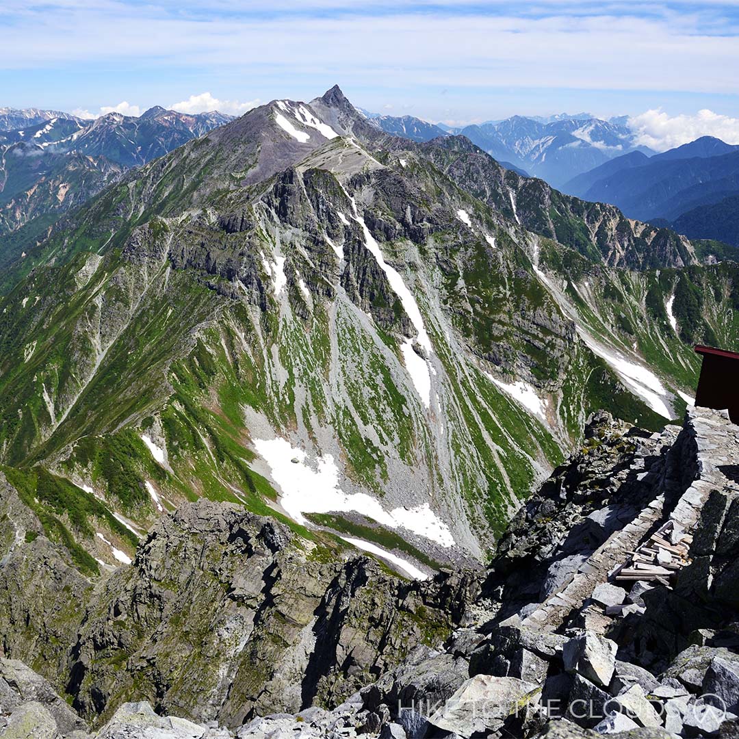
Mount Yari (Yarigatake)
- Area: Hida Mountains, Northern Alps
- Height: 3180m
- Yama to Kogen Map: No.38 槍ヶ岳・穂高岳 上高地 Yarigatake
Mount Yari is the 5th tallest mountain in Japan and as such is a must hike on any experienced hiker's list. It takes it's name from the Japanese word for "spear" as it is said to resemble a spear peircing the sky. The most popular month to hike is August when the snow has melted.
Yarigatake Sansou Official Website (English)Kamikochi Resort Hotel Association Website (English)
百名山
Via Train and Taxi (Kamikochi Route / Yarisawa Route)
You can gain access to Kamikochi via train, but from there most hikers go by car to the trailhead. Taxis are available in the area
By Bus (Kamikochi Route / Yarisawa Route)
Some people hike from Kamikochi Bus Station to the Yoko hut (About 14km).
You can get a bus from Shinjuku Bus Station to 平湯温泉バス停 (4h 25 mins), from Hirayu Onsen take the Kamikochi line to Kamikochi bus terminal (25 mins). The bus company is called Nohi Bus. See the Nohi Bus link below for more details
Train and Bus (Shinhotaka Route)
Alpico has direct buses from Shinjuku Bus Station to Kamikochi bus Station.
Take a train/shinkansen/bus to Takayama Station (高山駅) in Gifu, take the bus bound for Shinhotaka Onsen (新穂高温泉) to the last stop (around 1h 30mins).
There are buses available from Shinjuku Bus Station to Takayama Station (5h 30mins).
Via Car (Shinhotaka Route)
There is free parking for hikers at the Ryokan Shinhotaka Okuhida. From there head up the road, past the ropeway, and another car park at the top of the hill to reach the trailhead. Maps are available at the lodge, but there are signs as well.
The Japan Alps Website (English) - for information on access via KamikochiNohi Bus (English) - for buses from Shinjuku Station
Alpico Group Buses (English) - for buses to Kamikochi from Shinjuku / Tokyo / Shibuya and other areas
There are multiple Trailheads to Yarigatake Summit
Both the Kamikochi Route and Shinhotaka routes are very popular. The most difficult route from the Kamikochi side is along Yarihotaka Ridge.
Experienced hikers could also trek the Hotaka Peaks from the Gifu side along the Nishikama Ridge; or hike along the Higashikama Ridge (Higashikama-one) from the Nagano side
Kamikochi Route (Yarisawa Route)
Mt. Yari can be climbed from Kamikochi over the course of two or three days depending on your fitness level. Strong intermediate hikers should be able to complete this route without too much difficulty.
Once you reach the trailhead there are marks and signs to keep you on the right path
There are plenty of lodges along the way, but remember, most of them require reservations. Although some huts accept up to 3 hikers without reservation. See the link below for more information and basic route maps.
Easy 3 Day Example Itinerary
Day 1
Kamikochi Bus Terminal ~ Yokoo Campsite (3h)
Yokoo Campsite ~ Yarisaawa Lodge (1h 40mins)
Yarisawa Lodge
Day 2
Yarisawa Lodge
Tengu Pond
Mt Minamidake
Yarigatake Sanso Hut
Day 3
Yarigatake Sanso
Tokusawa Campsite
Kamikochi Bus Terminal
Yarigatake Sansou Group Website (English)Trekking from Kamikochi (English)
There are 4~5 huts along each of the most popular routes.
Yarigatake Sansou rents helmets to hikers going up to the peak
Yarigatake Sansou Group Website (English)Mount Hotaka

- Area: Hida Mountains, Northern Alps
- Height: 3190m
- Yama to Kogen Map: No.38 槍ヶ岳・穂高岳 上高地 Yarigatake/Hotakadake
Mount Hotaka (Hotakadake) actually refers to a series of peaks which include Mt. Okuhotaka, Mt. Nishihotaka, Mt. Maehotaka and Mt. Kitahotaka. Mt. Okuhotaka (okuhotakadake) is the third highest mountain in Japan, and the highest mountain in the Northern Alps.
Kamikochi Official Website (English)百名山
Via Train and Taxi
You can gain access to Kamikochi via train, but from there most hikers go by car to the trailhead. Taxis are available in the area
By Bus
Some people hike from Kamikochi Bus Station to the Yoko hut (About 14km).
Alpico is a night bus with direct bus routes from Shinjuku Bus Station to Kamikochi bus Station.
You can get a bus from Shinjuku Bus Station to 平湯温泉バス停 (4h 25 mins), from Hirayu Onsen take the Kamikochi line to Kamikochi bus terminal (25 mins). The bus company is called Nohi Bus. See the Nohi Bus link below for more details
Nohi Bus (English) - for buses from Shinjuku StationAlpico Group Buses (English) - for buses to Kamikochi from Shinjuku / Tokyo / Shibuya and other areas
As you can imagine, there are a lot of routes to Mt Hotaka. Here is our recommended route.
Kamikochi Round Route
Distance: 36km
Time: 16h 30mins without stops (times will vary depending on fitness)
Day 1
Kamikouchi ~ (55 mins) ~ Myojin ~ (1h) ~ Tokusawa ~ (1h 10 mins) ~ Yokoo ~ (1h 20 mins) ~ Hondani-bashi ~ (1h 40 mins) ~ Karasawa
We recommend spending your first night at Karasawa Hutt
Day 2
Karasawa ~ (1h 30 mins) ~ Seitengrat Ridge ~ (1h 20 mins) ~ Hotaka-dake sanso ~ (50 mins) ~ Mt. Okuhotaka ~ (40 mins) ~ Hotakadake Sanso
Deposit any extra weight at Hotakadake Sanso and take a day pack to hike up to Mt Okuhotaka and back, then spend your second night at Hotakadake Sanso
Day 3
Hotakadake sanso ~ (1h 30 mins) ~ Karasawa ~ (1h) ~ Hondani-bashi ~ (50 mins) ~ Yokoo ~ (1h 10 mins) ~ Tokusawa ~ (1h) ~ Myojin ~ (55 mins) ~ Kamikouchi
Mountain Huts / Helmet Rental / Restaurant
Karasawa Hut rents helmets if you don't have your own.
Huts/Lodges
Myojin Kan, Tokusawa Lodge, Tokusawa-en, Yokoo Sanso, Karasawa Hutte, Karasawa-goya, Hotaka-dake Sanso
Restaurants
There is a dining area on the second floor of the Kamikochi Bus Station
It is possible to purchase food at all the mounatain huts along the way.
Karasawa Hutt (Official Site Japanese)Hotakadake Sanso (Official Site Japanese)
Mount Tsurugidake

- Area: Kita Alps (北アルプス)
- Height: 2999m
- Yama to Kogen Map: No.37 剱・立山 Tsurugi/Tateyama
Another of Japan's most dangerous mountains. Despite claiming fewer lives than the infamous Mount Tanigawa, Tsurugidake is the mountain for thrill-seekers. This mountain is a cross between climbing and hiking as it would be impossible to get up the vertical rock faces without the use of the ladders and chains anchored to the edge of the cliffs. If sidling along a ledge with a 2000 metre drop below you sounds like fun, then this is the mountain for you!
百名山
Tsurugidake is accessible by train, funicular (cable car) and bus.
Take the Hokuriku Shinkansen from Tokyo Station to JR Toyama Station (around 2 hours). From there it's about a 10 min walk to Dentetsu Toyama Station where you can take the Toyama Chiho Tetsudo train to Tateyama Station (around 1 hour).
Once at Tateyama Station, take the Tateyama Cable Car to Bijodaira Station (7 mins). After that, take the Tateyama Kogen Bus to Tateyama Murodo (around 50 mins).
Medium to Difficult (at least 2 days)
Tsurugidake has a variety of routes for varying abilities. Advanced routes start in Chihirou Valley or Heizou Valley. Healthy and athletic beginners can tackle trails starting in Hayatsuki or Bessan; However, even the lower level trails include dangerous areas with ladders and chains, so we wouldn't advise this course for anyone but the physically fit. Likewise, if you have a paralysing fear of heights, you may wish to hike elsewhere or stop at the first "fake" summit at 1500 meters above sea level. Further up there are areas where you will be clinging against the edge of a mountain, with nothing but a chain to grip hold of.
The Murodo Route: The most popular route starts at the Murodo bus terminal, is around 14.4 km and takes roughly 12 hours 40 mins (without breaks). You will need to book a mountain hut for a one night stay.
Murodo bus terminal ~ (55 mins) ~ Raicho-daira ~ (1h 50 mins) ~ Bessan-Nokkoshi/Bessan-Pass (This is where the camp site and mountain huts are) ~ (1h 5 mins) ~ Kenzan-so ~ (30 mins) ~ Ippuku-tsurugi ~ (40 mins) ~ Zenken ~ (1h 20 mins) ~ Mt. Tsurugi ~ (1h 20 mins) ~ Zenken ~ (40 mins) ~ Ippuku-tsurugi ~ (20 mins) ~ Kenzanso ~ (1h 40 mins) ~ Betsuzan-nokkoshi ~ (1 hour 10 mins) ~ Raicho-daira ~ (1 hour 20 mins) ~ Murodo bus terminal
From Murodo to Raicho-daira - The first 30 minutes or so will take you on a well maintained paved footpath past the Mikuriga and Rindo ponds. The second stretch is 25 minutes of stair climbing. From Raicho-daira, walk up a rocky slope through some fields, and yet another rocky area to get to Bessan-nokkoshi (Bessan Pass), this is where you will find the first mountain hut (Tsurugi-gozen-goya). Keep going down a rocky slope (and past the camping grounds) to get to the second mountain hut (Tsurugi-sawa). Walk another 20-30 minutes through the stone pine belt to get to the Kenzan-so mountain hut, the third and final mountain hut. The next section is where it gets tricky...and dangerous. After walking up to the Ippuku-tsurugi peak, there is a long chain section to Mae Tsurugi. From there, a steep incline with narrow ledges and chains, followed by more ladders and chains. In high season, hikers may wait for up to an hour to get through these tricky sections. The path splits off into 2 routes, one for ascent and one for descent. On the pathway up you will come to Kani-no-tatebai and on the route back down Kani-no-yokobai. Kani-no-yokobai means walking sideways like a crab, and refers to the sections where you need to shuffle sideways along a narrow ledge while holding a chain to keep you on the mountain. Kani-no-tatabi means crawling upwards like a crab. After climbing Kani-no-tatabi you will get to a gentler slope leading up to the summit. Congratulations! You made it!
Deaths do occur every year on Tsurugidake, please make sure to prepare well for any hike you undertake on this mountain. It is incredibly important to stay on established trails and watch out for sudden dropoffs.
Mount Tateyama: For those who wish to admire the gorgeous nature without breaking a sweat (or the fear of death), there is also the option of doing the Tateyama Kurobe Alpine (pronounced Alpen) Route, a popular sightseeing tour using coaches, cable cars and trolleybuses with only 15 minutes on foot. The route is sometimes referred to as "the roof of Japan" as passengers pass through the stunning scenery of the Japanese Alps.
Tateyama Alpine Route Website (English)Mountain Huts / Camping Ground
The huts are usually open between the end of July and the end of October. Note that if you plan on staying in the mountain huts, you usually need to reserve your space in advance.
The Tsurugi-gozen-goya mountain hut is on the Bessan Pass. It takes around 2 hours 50 minutes to get there from Murodo.
The Tsurugisawa-goya mountain hut is a further 1-hour hike down the slope from the Bessan Pass, past the camping ground.
Rates and info
One night + 2 meals: ¥12000
One night + dinner: ¥11000
One night + breakfast: ¥10000
Sleep only (no meals): ¥8000
Packed Lunch: ¥1000
The Kenzan-so mountain hut is further up the alpine trail close to the Ippuku Tsurugi peak (or the "fake" peak). It takes 2.5 hours to get to the true Summit from Kenzan-so.
Gonzen-Goya Mountain Hut Official Website (Japanese)Tsurugisawa-goya Mountain Hut Official Website (Japanese)
Kenzan-so Mountain Hut Website (Japanese)
Mount Aka (Akadake - Yatsugatake Range)

- Area: Yatsugatake, Nagano, Yamanashi
- Height: 2899m
- Yama to Kogen Map: 33 八ヶ岳 Yatsugatake
Yatsugatake is an immense mountain range split into Northern and Southern regions. Akadake is the highest peak in the Yatsugatake Mountain Range and part of the Southern Region. While the Northern Region is lush and pretty, the Southern Region is majestic and awe-inspiring. Legend has it that Akadake once rivalled Mount Fuji in height. After a competition, the jealous Fuji smashed Akadake into pieces creating the mountains remaining today. Taking in the striking Akadake rising from the clouds, it is easy to see how the legend came about.
百名山
Access
Train and Bus / Taxi
Take the JR Chuo Line Limited Express train from Shinjuku Station and get off at Chino Station (2 h 10 mins). Take a Bus from Chino Station to Minotoguchi (around 40 mins). Go to the west exit bus stop (西口のバス停) and take the Minotoguchi Line (美濃戸口線).
NB: There are very few buses a day. If you plan to go using public transport we recommend staying 1 night on the mountain.
Check the timetable for the 9991 route from Chino 茅野駅 to Minotoguchi 美濃戸口 hereCar
Get off the highway at Kobuchizawa IC (小淵沢IC) ~ take national road 国道11 ~ follow the prefectural road 県道484
There is a carpark at Minotoguchi 美濃戸口 that is free. If you drive up to Akadake Sanso and Minotoguchi Sanso there are a further 2 carparks which can each take up to 70 cars. The parking fee is ¥1000 per day (subject to change by owners). While parking at the Sanso knocks 1 hour off your hike, the road is very rough. If your car is low to the ground you may have difficulties. We don't recommend driving up this road unless you have a 4 wheel drive.
There are multiple routes up to the Akadake Summit
While it is possible to do some of these trails in one day, we recommend staying 1 night on the mountain.
Akadake
Minotoguchi ~ (1h) ~ Akadake Sansou ~ (2h) ~ Akadake Kosen (赤岳鉱泉 this is our recommended camp site and lodge) ~ (45 min) ~ Gyojya Goya (行者小屋 another lodge with a camping area) ~ (1h) ~ crossroads between Amidadake and Akadake ~ (40 mins) ~ Akadake Summit ~ (20 mins) ~ Akadaketenbousou 赤岳天望荘 (Lodge on the ridge just below Akadake) ~ (5 mins) ~ Jizounokashira (地蔵の頭 a signpost with a Jizo Statue) ~ (1h 5 mins) ~ Gyojya Goya ~ (40 mins) ~ Akadake Kosen (赤岳鉱泉) ~ (1h 30 mins) ~ Akadake Sansou ~ (50 mins) ~ Minotoguchi
Start at Minotoguchi, head to Akadake Sanso on the road. From Akadake Sanso take the left trail for 2 hours along a river until you reach Akadake Kosen (赤岳鉱泉). We recommend pitching your tent here (or checking in at this lodge), deposit your large bag switch to a day pack. Don't forget your helmet. Next take the route to the right of sansou. Go past the toilets and the trail will be in front of you. After around 45 minutes you should reach Gojya Goya, another popular lodge in the area. Go through the campsite and up left. Keep going until you reach some steep stairs. Once you reach the top of the stairs Amidadake will be on your right, head left towards Akadake. Make sure you have your helmet on, this time there are steep rocks. You will have to use your hands and climb a bit to get to the peak. There are some areas with chains and ladders towards the top.
After admiring the view (and maybe having some lunch - the best spot is behind the shrine), head over and past the sanso, then down. There is a ledge that is pretty tight but very short. Once you are over the rocks head down the steep zig zag path. Don't get cocky, it is worth keeping hold of the chain here, anyone can slip here. Akadaketenbousou (赤岳天望荘) will be infront of you (we got our badges here). Walk on a little further until you reach a signpost with a Jizo statue. Take the path down to your left. This path is currently under construction (2021) but it is possible to get down. The first section you will need to do a bit of climbing. You will end up back on a wood trail which will lead you back to Gyojya Goya (行者小屋). From the lodge retrace your tracks (trail to the right) back to Akadake Kosen where you can spend the night, or head back down to the trailhead if you prefer.
There are several lodges and campsites along each of the most popular routes. We recommend Akadake Kosen 赤岳鉱泉. The staff are friendly and welcoming, and the food is delicious.
There is drinking water available at both Akadake Kosen and Gyojya Goya.
There are toilets at the lodges which you may need to pay to use.
Mt Fuji

- Area: Yamanashi / Shizouka (山梨・静岡)
- Height: 3776m
- Yama to Kogen Map: No.32 富士山 Mount Fuji
The majestic Mount Fuji is the most famous mountain in Japan. Every year around 250,000 people visit the national treasure. At 3376m in height, climbing Fuji should not be done without proper preparation.
百名山
It is possible to get to Mount Fuji by train and bus, or by car.
Mount Fuji is shut to the public during the winter season. Peak season is between July and September.
By Train and Bus
Take the Fujikyu Line to Kawaguchiko Station (the last stop on the line). The Fujitozan bus to the 5th station where you can access the Yoshida Trail. The bus stop is located in front of Kawakuchiko Station. Buy tickets for the bus at the ticket office in the station.
By Car
It is possible to travel by car as far as the 5th station where the majority of climbers begin their hike. There are several 5th stations and 4 trails up and down the mountain (Yoshida / Fujinomiya / Subashiri / Gotenba). There are no restrictions on passenger car traffic for the Gotenba Trail, however, there are periods of restriction on some of the other trails. There are car parks at the base of the mountain with a shuttle bus during the restricted periods. It is easy to end up at a different 5th station on the way down, so make sure you keep track of your route.
Restriction periods are as follows. Yoshida Trail: July 10th 5:00 pm ~ September 10th 5:00 pm. Parking: Fujisan Parking. Subashiri Trail: July 10th 12:00 pm ~ September 10th 12:00 pm. Parking: Subashiri Multipurpose Square. Fujinomiya Trail: July 10th 9am ~ Setember 10th 6pm. Parking: Mizugatsuka Parking.
Hike To The Clouds Tip:
The Yoshida Trail is the most popular and therefore the most crowded. It is also the trail that is easiest to access for tourists. For this reason, we recommend trying to avoid the Yoshida Trail if possible.
As with any mountain, weekends are often busier than weekdays. So try to go during the week.
Click here to access the Official English WebsiteSome may say that Mount Fuji is an easy climb, we have to agree to disagree. The climb to the summit can take anywhere between 5 and 10 hours depending on which route you take, and another 3 to 4 hours to descend. Quite often it is difficult to go at your own pace due to narrow pathways. There are some steep inclines and it is easy to slip on loose rocks and dirt. Weather conditions are not always as perfect as the picture above suggests, with unpredictable and sudden changes, conditions can get extreme pretty quickly. Some may find it difficult to adjust to the altitude. There are mountain huts on the upper levels where you can take a rest or even sleep. We recommend taking your time and doing a 2-day hike to allow your body to adjust slowly to the altitude.
Along the way, there are basic mountain huts, toilets and even vending machines.
Mount Shibutsu
- Area: Oze (尾瀬)
- Height: 2228m
- Yama to Kogen Map: No.14 尾瀬 Oze
At 2228 meters Mount Shibutsu really does give you the chance to hike to the clouds, and the views over Oze's luscious wetlands makes you feel as if you could be looking down from heaven.
To find out more about Oze Region (Japanese)百名山
Shinkansen
Take the Joetsu Shinkansen from Tokyo Station to Jomo Kogen Station (1h 20 mins).
From Jomo Kogen Station, take a Kanetsu Kotsu bus to reach Togura (戸倉) (2 hrs). Change to a shuttle bus at Togura to get to Hatomachi Pass (30 mins).
Option 2: Take a train to Numata Station (沼田駅).
Once you arrive take a bus for Hatomachi-Toge 鳩待峠. Transfer to a shuttle bus at Togura (戸倉).
Oze Preservation Foundation Route Page (English)It takes around 3 hours to get to the top and another 2 hours or so to get down. Despite the relatively short hike (compared to some of the others on this page), and a well maintained easy to follow trail, we would describe this hike as challenging. The route is deceptively rocky with some areas needing chains to help you up. The rest of the trail consists of wooden stairs and a lot of wooden planks which become pretty slippery in wet weather. We have seen some of the most stunning slip and slides on this mountain even by the most experienced hikers.
There are two options to climb Mount Shibutsu.
Option 1: Climb up from the Yama-no-Hana trail and descend on the Hatamachi-Toge trail.
Option 2: Climb up from Hatamachi-Toge and retrace your steps back on the way down.
The Yama-no-Hana trail is used solely for ascent as the rocks make it dangerous for those descending (we would agree to disagree - but those are the rules). The trails are clearly marked in Japanese. For those who don't know the Kanji (and let's face it, even if you do know a lot of kanji, place names are difficult) 鳩待峠 (Hatamachi-Toge) / 山ノ鼻 (Yama-no-Hana). You may see a trail branching off partway up marked 笠ヶ岳 (Mount Kasa), don't take that route unless you want to go to a different mountain.
Toilets / Mountain Tea house / Visitor Centre
All amenities are at the Hatomachi-Toge rest area at the start of the trail. After that, you are on your own.
Mount Iide (飯豊山)

- Area: Fukushima / Niigata / Yamagata
- Height: 2105m
- Yama to Kogen Map: No.10 飯豊山
- Best time: July ~ August
Hoping for a multiday trek in the Tohoku region, look no further! The Iide Mountains are chock full of amazing trails. The abudance of lodges mean that you can hike for days and still get a healthy hot meal.
百名山
Access
The Iide Mountains are most easily reached by car, but there are some buses in the peak season.
Car: Head to Osawa Camp Grounds (御沢キャンプ場). There is a free carpark next to Osawa camp grounds that has around 70 spaces.
Train and Bus: Take the Tohoku Shinkansen to Koriyama Station. Then take a the JR Banetsu West Line to Yamato Station (JR磐越西線 山都駅), from there get a bus to Kawairi (川入). The bus takes around 45 mins. The Kawairi bus stop is a 30 minute walk to the Osawa Campsite.
The buses only run twice a day and only between July and September.
Another option is to get a train to JR Banetsu West Yamato Station (JR磐越西線 山都駅) and then get a taxi (around 40 mins) to Osawa Camp. The taxi fare usually costs around ¥7500.
Helpful phone numbers
Yamato Taxi: 0241-382-025
Coming Soon
Toilets
There are toilets at the Osawa Camp.
Water
There is water available at Osawa Camp.