Getting started!

You don't need to be an Olympian to enjoy the outdoors.

drop-8 drop-9 drop-9 drop-9 drop-9 Get out in the fresh air!

Ougatou - Utsukushigahara (王ヶ頭, 美ヶ原)

  • Area: Nagano
  • Height: 2034m
  • Yama to Kogen Map: No.33 八ヶ岳 Yatsugatake / Utsukushigahara

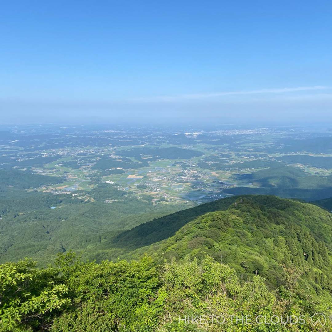
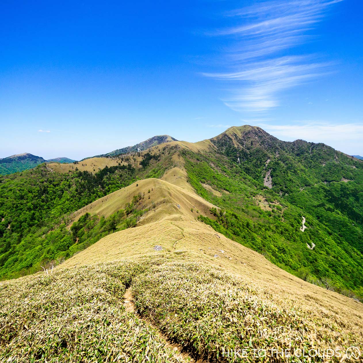
Despite its height of 2034m, this mammoth mountain is great for hikers who are just starting out. Ougatou is pretty in the Summer when you can see lots of cows grazing in the area, but also fun in the winter. If you want to try out snowshoeing for the first time, the flat expanses make this a fantastic place to practice.

Read more about the 5 easiest top 100 百名山 mountains here

 百名山

Train and Taxi: The nearest train station is Matsumoto Station on the JR Chuo Line. For those staying at Ougatou Hotel, there is a free shuttle bus from the Matsumoto Station. If you aren't staying at the hotel, a taxi from the station to Utsukushigahara Car Park will cost around 1万 yen. On the way back, Alpico Buses run from Utsukushigahara Art Museum to Matsumoto Station. The ride takes 1h 40m.

Train and Bus: Alternatively, go in the oposite direction taking a bus from Matsumoto Station to Utsukushigahara Open-Air Museum.

Car: Leave the highway at the Matsumoto interchange in Summer or Winter seasons. In warmer seasons the Mountain is also accessible via the Okaya Interchange.


Helpful phone numbers
Matsumoto Taxi: 0263-331-141
Matsumoto City Tourist Information: 0263-322-814


Helpful Websites
Alpico Bus Utsukushigahara Plateau Guide (English Website)

drop-8 drop-9 drop-9 drop-9 drop-9

  • Time: 2h 15 (roughly 4h round trip)
  • Elevation Change: 220m

The hiking route is pretty flat, starting at the Utsukushigahara Kogen Car Park and ending at the Utsukushigahara Open-Air Museum. If you have come by car, you may need to return the way you came, making your hike just over 4 hours. You could shorten the walk by turning back once you reach Utsukushigahara No Tou (美ヶ原の塔).

Utsukushigahara Kogen Car Park ~ (30m) ~ Ougahana (王ヶ鼻) ~ (30m) ~ Ougatou (王ヶ頭) ~ (30m) ~ Shio Kure Place (塩クレ場) ~ (10m) ~ Utsukushi no Tou (美しの塔) ~ (15m) ~ Yamamoto hut (山本小屋ふる里館) ~ (20m) ~ Utsukushigahara Open-Air Art Museum (美ヶ原美術館)

Toilets / Hotel / Open-air Museum

Toilets: There are toilets in the carparks.


Hotel: Ougatou Hotel sits at the summit. The perfect place for watching the sunrise and sunset on the mountain in comfort.
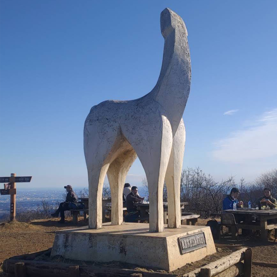
Ougatou Hotel Webiste (English)

Open-Air Museum: Combining art and nature the Utsukushigahara Open-Air Museum has more than 350 sculptures. Situated on a 2,000-meter-high plateau, there are 360 views of the surroundin Japan Alps.

Utsukushigahara Open-Air Museum (English Website)

Utsukushigahara Kogen Tourism Website (Japanese)
Yamato Goya Furusatokan Website (Japanese)

Mount Hodo 宝登山

  • Area: Chichibu (秩父)
  • Height: 497m
  • Yama to Kogen Map: No.22 奥武蔵・秩父

Famous for its seasonal blossoms, this baby mountain is a great day trip for all the family, including pets. The well maintained, short trail, makes this a fantastic mountain for beginners. For those who want to take it easy, take the cute yellow ropeway up to the mountain peak, where you can admire a view of the Chichibu Basin while eating one of their famous miso potato sticks.

Hodo is accessible via train, or by car.

By Train: The nearest station is Nagatoro Station (長瀞駅) on the Chichibu Main Line (秩父鉄道).

For easiest route, take the JR Shonanshinjyuku Line (湘南新宿ライン) to Kumagaya (熊谷駅) then change to the Chichibu Main Line (秩父鉄道). It takes about 2.5 hours from Shinjuku Station.

Once you have arrived at Nagatoro Station you can take the free shuttle bus to Hodo Ropeway. The bus departs every 15~30 minutes.

By Car: There are 2 large car parks close to the Ropeway Entrance, as well as one carpark next to Hodo Shrine.

Parking costs ¥500 for the day

If you don't mind walking a bit further, there are small carparks in the town. They are around ¥200 for the day.

Tip for those with young children: If you have very little ones who can't walk very far, we recommend taking the free shuttle bus from the station to the ropeway. While it doesn't seem very far for adults, some parents have commented that it was a difficult walk with their little ones.

drop-8 drop-9 drop-9 drop-9 drop-9

Hiking Mount Hodo is an easy 40 minute stroll (uphill). There are plenty of benches and stopping points on the way for those who decide to hike with their children.

The path is well maintained, with clear signs. So it's pretty impossible to get lost. We recommend wearing a sturdy pair of sports shoes (or hiking boots) as the paths are covered with rough gravel and rocks.

There is a very small section with steps close to the summit. If you would prefer not to use stairs, take the path to the right, towards the petting zoo. If you follow the path up past the petting zoo, you will arrive at the top ropeway station.

Rope Way / Toilets / Restaurants / Picnic area

Rope Way Fares

Over 12 years: ¥480 (one way), ¥820 (round trip)

Children 6~12 years: ¥240 (one way), ¥410 (round trip)

Five years and under go free

Pets are welcome but must have a ticket

Discounts are available to those with a disability handbook

Official Ropeway Website (Japanese)


drop-8 drop-8 drop-9 drop-9 drop-9 Ready to walk a little further!

Hatonosu Valley Walking Course 鳩ノ巣渓谷

  • Area: Okutama (奥多摩)
  • Length: 8.5km

Take a scenic walk along the river and through the woods. A great hike for beginners who want to experience different types of terrain. Stop off at one of the stations on route to try local foods or bring a packed lunch and eat next to the river.

The valley is accessible via train.

Train: From Shinjuku take the JR Chuo Line to Ome Station (青梅). You may need to change at Tachikawa Station depending on the train you get. Once at Ome Station, switch to the JR Ome Line (青梅線) get off at Okutama Station (奥多摩駅).

drop-8 drop-8 drop-9 drop-9 drop-9

Moderately easy 8.5km hike which can be cut shorter as you pass 2 stations on the way.

Okutama ~ Kori

If you take the Okutama to Kori route, there is very little incline, most of the route is flat or downhill

Kori ~ Okutama

Going the opposite way, you will have some uphill stretches and steps to climb.

PDF Course Map (English)
Okutama Visitor Center Website (Japanese)

Toilets / Restaurants / Picnic area

Picnic Area: There are picnic tables near to the dam. There are also plenty of pebble beaches and rocky areas that are great for picnics.


Restaurants: There are several stations along the way with great restaurants. There is a delicious hamburger steak restaurant near the river, pizza restaurants and traditional restaurants serving kamameishi.


Toilets: There are toilets outside the stations and more toilets at various points along the trail.

Kirigamine 霧ヶ峰

  • Area: Nagano (長野県)
  • Height: 1925m
  • Yama to Kogen Map: No.33 Yatsugatake Tateshina / Utsukushigahara / Kirigamine 八ヶ岳 蓼科・美ヶ原・霧ヶ峰

Our favourite Top 100 Mountain for beginners. The area, which is a mixture of grasslands and marshlands, is home to over 600 species of flora, the most spectacular being the yellow Daylilies that blanket the plains during the Summer months. Hikers often spot foxes, weasels, deer, butterflies and rare birds on their outings. From Kurumayama - the highest peak, there are 360° panoramic views looking over the Northern, Central and Southern Japanese Alps.

 百名山

Access

  • By Train and Bus

By Train and Bus 1: Head to Chino Station 茅野駅. Then take the Alpico Bus アルピコ交通 to Kuruyama Kata(1h 5m).

By Train and Bus 2: Head to JR Kami-Suwa Station 上諏訪駅. Then take the Alpico bus アルピコ交通 (40m) to Kurumayama Kata.

By Train and Taxi: Head to JR Kami-Suwa Station 上諏訪駅. A taxi from Kami-Suwa Station takes about 30m and costs around ¥6000.

By Train and Bus 3: Head to Sakudaira Station 佐久平駅. For those coming from Tokyo it is reachable via the Nagano Shinkansen (1h 10m). Then take a bus (1h 30m) to Kurumayama Kogen.

  • By Car

Head to Kurumayama Kata 車山肩. Take the Suwa I.C 諏訪IC > National Road 20 国道20号 > Prefectural Road 40 県道40号. There is a free carpark.

  • Helpful Websites

Kurumayama Kogen (Official English Website)
Kuruyama Kogen Access Page (English Website)
Nihonmatsu Tourism Federation (Japanese)


  • Helpful Phone Numbers

Alpico Bus: 0266-72-2151
Alpico Taxi: 0266-71-1181
Suwa Tourist Information: 0266-52-2111


  • Beginner 初級
  • drop-8 drop-8 drop-9 drop-9 drop-9
  • Time: 4h 40m
  • Elevation Change: 480m

Kurumayama Kata (車山肩) ~ (45m) ~ Kurumayama (車山) ~ (45m) ~ Chochomi Yama (蝶々深山) ~ (1h) ~ Okukiri Goya (奥霧小屋) ~ (30m) ~ Yashimaenchi (八島園地) ~ (40m) ~ Hutte Misayama (ヒュッテみさやま) ~ (20m) ~ Sawatari (沢渡) ~ (40m) ~ Kurumayama Kata (車山肩)


From the Car Park head up through Kurumayama Kata to Kurumayama (車山). Kurumayama is the prominent peak and Top 100 Mountain (百名山), at the top there is a Radar Dome (レーダードーム) and a stand which points out noteworthy mountains and landmarks visible from the summit. When you are finished admiring the view, it is time to head down past the Kurumayama marshlands and onto the next peak, Mount Chochomi (蝶々深山 (For those who don’t speak Japanese, chocho means butterfly - probably named after all the stunning varieties found in the area). From there, head down the stony trail and past the Monomi Iwa rocks (物見岩) to Okukiri Goya (奥霧小屋). There is a deer gate here that you will need to go through. The sign says to make sure to shut the gate again after you have passed through. You will pass a large pond and come out into another marshland (Yashima Pond 八島ヶ池). After walking for around 30 minutes on the wooden path, you will arrive at Yashima Enchi (八島園地). This is a great place to take a break and eat lunch. There are several huts, a cafe, toilets, and a visitor centre where you can learn more about the nature in the area. Once you are sufficiently rested, it is 40 minutes to the next hut (ヒュッテみさやま which also has toilets), and a little shrine. From the hut, it is 20 minutes to Sawatari (沢渡), and from there, you are on the home stretch. Head up the road to reach your final destination (and starting point), Kuruyama Kata.

Lodge / Campsite / Restaurant

  • Restaurant

There is a small giftshop with restaurant next to the carpark.


  • Lodge

The cozy Misayama Hütte (ヒュッテみさやま) is more like a cute b&b than your traditional mountain hut.

The Hütte cafe and shop is also popular with hikers during the daytime.

Misayama Hütte Website (Japanese)

  • Campsite

There is a spacious campsite run by Suwa City 5 minutes down the road by car. It is possible to walk from the campsite to the peak. The campsite is low priced, clean, and pretty. If you have a Montbell membership you can get a further discount.

Kirikomi Lake 切込湖・刈込湖

  • Area: Oku-Nikko (奥日光)
  • Distance: 5 ~ 14km depending on your chosen route
  • Yama to Kogen Map: No.13 Nikko 日光 白根山・男体山

Take a relaxing walk around this lava couldron followed by a dip in one of the famous onsen. If you are a very beginner this is a fantastic trail for you to build up your endurance, starting with shorter hikes and building up to full day hikes.

Access

Train: Use a bus bound for Yumoto Onsen from Nikko Station on the JR Line or Tobu Nikko Station on the Tobu Line. The amount of time required is about 1 hour and 25 minutes.

Car: Enter Nikko Utsunomiya Road (limited highway) from the Utsunomiya Exit on the Tohoku Expressway and get off at the Kiyotaki Exit. Yumoto is about 40 minutes from the exit on National Route 120.

drop-8 drop-9 drop-9 drop-9 drop-9
  • Trail: Yumoto Visitor Center to Lake Kirikomi and back
  • Time: 2h 20mins (without breaks)


This well signposted trail takes you from Yumoto Visitor Center to Lake Kirikomi and back again.

Yumoto Onsen ~ (70m) ~ Lake Karikomi ~ (70m) ~ Yumoto Onsen


drop-8 drop-8 drop-9 drop-9 drop-9
  • Trail: Yumoto Visitor Center to Kotoku Pasture
  • Distance: 8.4km
  • Time: 3h 40mins (without breaks)


Alternatively, take a slightly longer route from Yumoto Visitor Center and Onsen, past Lake Kirikomi, finishing at Kotoku Pasture. From the Kotoku pasture you can take a bus back to the visitor center.

Yumoto Onsen ~ Lake Karikomi ~ Karenuma Marsh ~ Sanno Pass ~ Kotoku Onsen


drop-8 drop-8 drop-8 drop-8 drop-9
  • Trail: Clockwise round course from Yumoto Visitor Center
  • Distance: 13.8km
  • Time: 6h 10mins (without breaks)


If you are up for a challenge start early and do a full circuit. Follow the course above (Yumoto Visitor Center to Kotoku Pasture). From Kotoku Pasture it takes 2h 10mins back to Yumoto Onsen.

Yumoto Onsen ~ Lake Karikomi ~ Karenuma Marsh ~ Sanno Pass ~ Kotoku Onsen ~ Kotoku Iriguchi ~ Odashiro Bridge ~ Yudaki Falls ~ Yumuto Onsen


Lake Kirikomi / Lake Karikomi PDF Map from Nikko Yumoto Visitor Center
Hiking Courses around Yumoto Onsen PDF from Nikko Yumoto Visitor Center

Toilets / Onsen / Visitor Center

Onsen: Yumuto Onsen / Kotoku Onsen


Toilets: There are toilets in Kotoku carpark and inside Yumoto Onsen (North carpark)


Visitor Center: Nikko Yumoto Visitor Center is open every day from 9:00am ~ 4:30pm during April ~ November.

Almost the same hours apply (9:30am~4:30pm) from February ~ March, but it is closed on Wednesdays.

Open weekends only 9:30am ~ 4:30pm through December and January

In peak season (July and August) the visitor center has slightly longer opening hours 8:30am ~ 5:30pm.

Nikko Yumoto Visitor Center Website (English)

drop-8 drop-8 drop-8 drop-9 drop-9 Ready to test my strength!

Mount Aso 阿蘇山

  • Area: Kyushu (九州)
  • Height: 1592m
  • Yama to Kogen Map: No.58 Aso / Kuju Yufu-Dake 阿蘇・九重 由布岳

Located in Kumamoto Prefecture in the central Kyushu region, the humongous volcano is phenomenal. The five peaks that form the core of the volcano and lie in an almost perfect line east to west are called the Aso Gogaku (five peaks of Aso): Neko-dake, Taka-dake (the highest peak), Naka-dake (the most active crater), Eboshi-dake and Kishima-dake. The mountain massif is divided into two main sections: the west side (Kishima and Eboshi) and the east side (Neko, Taka and Naka). The gentle trails around the grasslands on the western side of the massive are perfect for beginner hikers. Tengu Iwa in the central zone is a rocky alpine climbing territory. The mountain is easily accessible, and hiking can be enjoyed all year round. Mount Aso is one of Japan's most active volcanoes. As the restriction levels often change, please check updates on the trails before hiking.

 百名山

Access

  • By Car

Head to Kusasenri Parking Lot (草千里駐車場). The carpark has 300 spaces and costs ¥500.

Google Maps
  • Public Transport

From Kumamoto Airport, take a Kuko Renraku (airport shuttle) “Yamabiko” bus to Aso Station (about 1h 30m). From Aso Station, take a Kyushu Kotsu Bus Lines Aso Kako Line bus to the Kusasenri Aso Volcano Museum Bus Stop (30m).

Mount Aso is an active volcano with ongoing activity. The Japan Meteorological Agency issues the latest eruption warnings and forecasts, so please check them before deciding whether to hike. There are also restrictions due to volcanic gases, so check local information on your route as well.

Check out latest restrictions here (English)

Japan Meteorological Agency Website (Japanese)

Mount Eboshi Route

  • Beginner 初級
  • drop-8 drop-8 drop-8 drop-9 drop-9
  • Time: 2h 20m
  • Distance: 4km
  • Elevation Change: 242m

This beginner route takes you through the grasslands and up to a summit overlooking the area.

Aso Volcano Museum (火山博物館前) ~ (1h 20m) ~ Ridgeline / Ryosen (稜線) ~ (20m) ~ Mount Eboshi (烏帽子岳) ~ (30m) ~ Aso Volcano Museum (火山博物館前)


Mount Kishima Route

  • Beginner 初級
  • drop-8 drop-8 drop-8 drop-8 drop-9
  • Time: 1h 40m
  • Distance: 4.3km
  • Elevation Change: 507m

This route is completely paved and can be tagged onto the route above for a longer hike.

Aso Volcano Museum (火山博物館前) ~ (20m) ~ Mount Kishima Bunki (杵島岳分岐) ~ (20m) ~ Mount Kishima (杵島岳) ~ (20m) ~ Kishima-Dake Trailhead (towards the ski-ground) (スキー場方面杵島岳登山口) ~ (15m) ~ Aso Volcano Museum (火山博物館前)

NB "分岐" (bunki) is a split or junction in the trail


See the Eboshi-Dake 烏帽子岳 and Kishima-Dake 杵島岳 trails on the left hand side of this map.

Kishima-Dake Trails PDF from Kumamoto Prefecture

Naka-Dake New Route (皿山ルート)

  • Intermediate 中級

We don't know a lot about this new route yet. See the map below to see the new route around the restricted trails.

Map PDF

Yama Ue Hiroba (山上広場) ~ Shin Tozan Do / New Hiking Route 新登山道 ~ 中岳 ~ Shin Tozan Do / New Hiking Route 新登山道 ~ Yama Ue Hiroba (山上広場)


As of 2019, volcanic activity, including eruptions, has caused both Naka-dake and Taka-dake to be declared restricted to hikers. In April 2022, the activity level was dropped from level 2 to level 1. Despite this, there is still a 1 km no go zone around the crators. Therefore THE ROUTES BELOW ARE CURRENTLY OFF-LIMITS. According to information on the Mount Aso website, trails are being prepared to be re-opened. We have left our guides up here for your information and in hope that they will be opened again at some point in the near future.

Map PDF showing where trails are restricted.

Neko-Dake Ridge Route 根子岳 大戸尾根ルート

  • Intermediate 中級
  • drop-8 drop-8 drop-8 drop-9 drop-9
  • Time: 2h 40m
  • Distance: 4.3km
  • Elevation Change: 810m

Mount Neko Emergency Hut Carpark (根子岳地獄谷避難小屋前駐車場) ~ (1h 30m) ~ Tohou (東峰) ~ (1h 10m) ~ Mount Neko Emergency Hut Carpark (根子岳地獄谷避難小屋前駐車場)


Eastern Side 中岳・高岳 Route

  • Intermediate 中級
  • drop-8 drop-9 drop-9 drop-9 drop-9
  • Time: 4h 25m
  • Distance: 7.5km
  • Elevation Change: 554m

Nakadake is the most active crater in the massif.

As this route passes near the crater, the risk of exposure to volcanic gases (sulphur dioxide) is high. These toxic gases can be deadly, so please think carefully and prepare accordingly before ascending the mountain. If you notice a strong odour, cover your mouth and nose with a wet towel and descend the volcano immediately.

Kakou Nishi Eki / Kakou West Station (阿蘇山西駅) ~ Sunasenrigahama (砂千里ヶ浜) ~ (1h 30m) ~ Naka-dake (中岳) ~ (40m) ~ Taka-dake (高岳) ~ (20m) ~ Taka-dake Nishi ~ (45m) ~ Taka-dake (高岳) ~ (30m) ~ Naka-dake (中岳) ~ Sunasenrigahama (砂千里ヶ浜) ~ (1h) ~ Kakou Nishi Eki / Kakou West Station (阿蘇山西駅)


  • Toilets

There are toilets available in the main carpark and at the visitor center.


  • Visiter Center

The Visitor Center is located in Kusasenri, the access base for climbing Mt Aso. The base area has a museum, cafes and toilets. Pop into the Visitor Center for maps and the latest information on the volcano activity.

Mount Aso Visitor Center Tel: 0967-34-2111

Visitor Center Official Website (Japanese)

Google Maps
  • Aso Volcano Museum
Aso Volcano Museum Information (English)

  • Hot Springs

Dondoko Onsen Website (Japanese)
Kurokawa Onsen (English)

Daibosatsu 大菩薩峠

  • Area: Yamanashi
  • Height: 2057
  • Yama to Kogen Map: No.25 Daibosatsurei 大菩薩嶺
  • Best Seasons: Autumn

Daibosatsu is an easy mountain hike with extraordinary views over Daibosatsu Lake all the way to Mount Fuji. This is a great mountain for beginners to start building strength.


 百名山

Access

By Car: There are 3 carparks. During Autumn season they can fill up quickly.


By Train and Bus: Take a train to Kaiyamato Station, transfer to Eiwa Kotsu Bus to get to Kaminikkawa-toge Pass.

drop-8 drop-8 drop-8 drop-9 drop-9

  • Time: 4h
  • Elevation Change: 571m

Car Park / Bus Stop (駐車場・バス停) ~ (30m) ~ Kaminikawatoge (上日川峠) ~ (30m) ~ Fukuchan Sou (福ちゃん荘) ~ (50m) ~ Daibosatsutouge (大菩薩峠) ~ (50m) ~ Kaminari Iwa (雷岩) ~ (10m) ~ Daibosatsurei (大菩薩嶺) ~ (10m) ~ Kaminari Iwa (雷岩) ~ (40m) ~ Fukuchan Sou (福ちゃん荘) ~ (20m) ~ Kaminikawatoge (上日川峠)

The trail is clearly signposted and easy to follow. Once you arrive at Kaminari Iwa you need to take a detour away from the main ridge to get to the actual summit. There isn't much to see at the summit itself, so take your obligatory "I was here" picture and head back to the main ridge for hopefully amazing views across the valley all the way to Mount Fuji.

Toilets / Hut

Toilets: There are toilets in the first car park and near to Fukuchan Sou Hut

Hut: Fukusan Sou Hut

Mount Azuma 吾妻山

  • Area: Fukushima (福島県)
  • Height: 2035m
  • Yama to Kogen Map: No.11 Bandai / Azuma (磐梯・吾妻 安達太良)

Mount Azuma is an active volcano with panoramic views over Fukushima City. It's also known as Mount Azuma-Kofuji, literally Little Fuji Azuma, which looks like a miniature Mount Fuji. Autumn is the most popular time to hike Azuma, but trails are open between April and November. If you have a few days and a car, we recommend camping near the Bandai-Asahi National Park lakes and hiking Mount Bandai and Adatarayama too.

 百名山

Access

  • Train and Bus

Prior to the pandemic buses ran from Fukushima Station and Yonezawa Station to the ropeway. However they are currently out of service (2022). For the time being, it is only possible to reach Azumaya by car.


  • By Car

The carpark at the Jododaira Visitors Centre costs ¥500 for the day.

Usagidaira Car Park is a free carpark 1km away from the Visitor Center and Azuma-Kofuji trail head.


  • Beginner 初級
  • drop-8 drop-8 drop-8 drop-9 drop-9
  • Time: 3h 25m
  • Hike up: 379m

The easiest route for beginners, which can be cut shorter if necessary.

Hokuboudai (北望台) ~ (20m) ~ Kamoshika Tenboudai (かもしか展望台) ~ (20m) ~ Okubo (大凹) ~ (40m) ~ Bonten Iwa (梵天岩) ~ (20m) ~ Mount Nishazuma (西吾妻山) ~ (10m) ~ Nishiazuma Hut (西吾妻小屋) ~ (10m) ~ Bouten Iwa (梵天岩) ~ (30m) ~ Okubo (大凹) ~ (25m) ~ Ningyo Ishi (人形石) ~ (30m) ~ Hokuboudai (北望台)

Take the ropeway and then three lifts to arrive at our 1820m starting point, Hokuboudai. You will see the beginning of the trail on your right once you arrive at Kamoshika Tenboudai (かもしか展望台). Please stay on the wooden path but be careful as it can get slippy in rainy weather. Take a right towards Okubo (大凹) (You will take the other trail to Ningyo Ishi (人形石) later on your return route). Keep following the wooden path up to Bonten Iwa (梵天岩). Take the left route up to Mount Nishiazuma summit. Well done! You have just bagged yourself another top 100 summit! Sadly the peak is surrounded by trees, so there isn't much of a view. From the summit, head around to Nishiazuma Hut, where toilets are available if needed. From here, make sure to take the right path towards Nishiazuma Shrine (西吾妻神社) and back to Bouten Iwa. Follow the path back the same way you came until your reach the branch. This time take the route to Ningyo Ishi (人形石), literally "Doll Rock", then follow the path left along a slightly rough trail back to the lifts.

Toilets

There are toilets at the ropeway stations.


Campsites

The Jododaira Campsite is the closest to the trailhead and managed by the Jododaira Visitor Center. According to the website, the price is ¥1000 for the site + ¥600 for each person (¥400 for children in elementary school or younger).

The campsite is open between May and October (exact dates vary by year).

Jododaira Campsite Website (Japanese)

Helpful Websites
Fukushima Tourist Information (English)
Joudodaira Bandai-Asahi National Park (English)
Joudodaira Visitor Center Website (Japanese)

Nishizawa Gorge 西沢渓谷

  • Area: North Yamanashi / Chichibu Tama Kai National Park
  • Length: 9km
  • Yama to Kogen Map: No.27 Kinpo 金峰山・甲武信
  • Best Seasons: May and October

If you love waterfalls, this one's for you. This hiking trail will take you past 8 sparkling falls, including one of Japan's top 100 waterfalls, the Nanatsugama Godan No Taki (7 pools and 5 step waterfall). Unsurprisingly this magical area is steeped in myth, and it is said that a diety may sometimes apear to hikers. The negative ions in the atmosphere make this the perfect place for forrest bathing.


滝百選

Access

Train and Bus: Take the train to Yamanashishi Station or Enzan Station. Yamanashishi is reachable via the Chuo line or via limited express train that runs from Shinjuku Station. The trailhead to the Nishizawa Gorge is a 60 min bus ride on the Nishizawa Keikoku Line from Yamanashishi Station (山梨市) or Enzan Station (塩山). Get off at the last stop (Nishizawa Keikoku Iriguchi 西沢渓谷入口). There ae only 4 buses a day from each station.

Buses From Yamanashishi 山梨市

9:12
10:21
13:50
15:17

Buses From Enzan 塩山

8:30
9:05
13:30
14:30

By Car: There are 2 car parks, Municipal carpark (60 spaces) and Michi No Eki Mitomi northern carpark (200 spaces). The carparks are usually free but they charge during the Autumn.

drop-8 drop-8 drop-8 drop-9 drop-9

  • Time: 3h 30m
  • Length: 9km

The trail is clearly signposted and easy to follow. The hiking route is one-way and counter clockwise.

The first part of the trail may feel steep for very beginners, young children and people with movement issues.

The second half of the trail follows an old rail track.

Nishizawa Gorge Entrance (西沢渓谷入口) ~ (30m) ~ Nishizawa Lodge (西沢山荘) ~ (20m) ~ Triple Falls (三重の滝) ~ (10m) ~ Human Faced Hollow (人面洞) ~ (10m) ~ Waterfall of the Dragon God (竜神の滝) ~ (5m) ~ Thread of love Falls (恋糸の滝) ~ (5m) ~ Spring of Righteousness Falls (貞泉の滝) ~ (5m) ~ Womb pool botaifuchi (母胎淵) ~ (25m) ~ Five Steps and Seven Pools Falls (七ツ釜五段の滝) ~ (5m) ~ Unmoving Falls Fudotaki (不動滝) ~ (15m) ~ Old Forrest Railroad Track (旧森林軌道) ~ (35m) ~ Okubozawa (大久保沢) ~ (30m) ~ Cheaters Bridge (ネトリ大橋) ~ (20m) ~ Nishizawa Gorge Entrance (西沢渓谷入口)

Nishizawa Gorge Map from Yamanashi Tourism Association (Japanese)

Toilets / Michi No Eki

Toilets: There are toilets in the car park and at the trailhead, Nishikawa Sanso and at the Mount Kurogane trail entrance at the half way point.

Michi No Eki Mitomi Michi No Eki (道の駅) is a shop that sells local delicacies and souvenires, as well as providing information about the area.

Nishizawa Gorge Pamphlet PDF from the Yamanashi Tourism Association (Japanese)

Mount Mitake 御岳山

  • Area: Okutama (奥多摩)
  • Height: 929m
  • Yama to Kogen Map: No.24 奥多摩 Okutama

Mitake is known for its waterfalls and cascading brook that runs the entire length of the rock garden trail. It is considered a "power spot", and you are sure to come away feeling re-energised and refreshed.


Mitake is accessible via train and bus, or by car.

By Train and Bus: From Shinjuku Station, take the Chuo Line to JR Tachikawa Station. From there transfer to the JR Ome Line and get off at JR Mitake Station. Some trains will go straight from Shinjuku to Ome Station where you can trasfer to the Ome line.

Once you arrive at JR Mitake Station 御岳駅, take the bus to Mitake Tozan Railway's Takimoto Station (滝本). Get off at ケーブル下 Cable Shita bus stop. The bus ride will take about 10 minutes.


By Car: The cable car carpark is open from 7:10am ~ 7:00pm.

Car: ¥350 per hour / ¥1500 for the day

Motorbike: ¥500 for the day

Bicycle: ¥200

Bus: ¥2600 for the day

Access Map (Japanese)
drop-8 drop-8 drop-8 drop-9 drop-9

There are 3 trails from the top ropeway station.


  • Mount Mitake Trail
  • Time: 1h 20m

Mitake San Ropeway Station (御岳山駅) ~ (10 mins) ~ Visitor Centre ~ (10 mins) ~ Jindai Keyaki (神代けやき a big tree) ~ (5 mins) ~ Nakazatokaizanhi Stone Plaque (中里介山碑 stone plaque commemorating a novel) ~ (10 mins) ~ Musashi Mitake Shrine (武蔵御嶽神社) ~ (35 mins) ~ Mitake San Ropeway Station (御岳山駅)


  • Rock Garden Trail
  • Time: 2h 40m

Mitake San Ropeway Station (御岳山駅) ~ (30 mins) ~ Nagaodaira Fork (長尾平分岐点) ~ (20 mins) ~ Nanayo Falls (七代の滝) ~ (15 mins) ~ Tengu-Iwa Boulder (天狗岩) ~ (30 mins) ~ Ayahiro Falls (綾広の滝) ~ (40 mins) ~ Nagadaira Fork (長尾平分岐点) ~ (25 mins) ~ Mitake San Ropeway station (御岳山駅)


  • Musashi Mitake Shrine and Nagadaira Trail
  • Time: 1h 20m

Mitake San Ropeway Station (御岳山駅) ~ (10 mins) ~ Visitor Centre ~ (25 mins) ~ Musashi Mitake Shrine (武蔵御嶽神社) ~ (5 mins) ~ Nagadaira (長尾平) ~ (25 mins) ~ Mitake San Ropeway Station (御岳山駅)

Trail Map PDF (English)
Mountain Map (Japanese)

Cable Car / Toilets / Restaurants / Picnic areas

Cable Car Fares

Adults: ¥600 (one way), ¥1130 (round trip)

Children: ¥300 (one way), ¥570 (round trip)

Pets are welcome but must have a ticket

Pet under 10kg: ¥130 (one way), ¥260 (round trip)

Pet over 10kg: ¥260 (one way), ¥520 (round trip)

Bicycle: ¥130 each way

Official Cable Car Website (English)

Mount Takao 高尾山

  • Area: Kanagawa (神奈川)
  • Height: 599m
  • Yama to Kogen Map: No.28 高尾・陣馬 Takao / Jinba

Mount Takao is one of Japan's most popular mountains receiving over 2.6 million people per year. As such, it is easy to reach and well maintained. The natural hiking trails are brimming with wildlife. Go in the Summer season to spot butterflies the size of your hands. The famous Yakuo-in Temple is a must-see before heading to the summit. Those with children may enjoy the monkey and wildflower park located near the top cablecar station.

Takao is accessible via train or car.

Train option 1: Take the Keio Line from Shinjuku Station to Takaosanguchi Station. From Shinjuku it takes roughly 50 minutes by express train and costs ¥390.

Train option 2: Take the Chuo Line to Takao Staion and then transfer to the Keio Line to Takaosanguchi Station.


By car: There are 2 parking lots convenient for hiking.

Takaosankitojo Parking Lot opens from 8:00am and costs ¥1000 for the day.

Yuryo Parking Lot is also close to Takaosanguchi and costs ¥1000 for the day. It is quite small and can get muddy on rainy days.

drop-8 drop-8 drop-8 drop-9 drop-9

There are several courses ranging in difficulty. Trail 1 is the busiest, with most of the way paved. If you would like to go on one of the natural trails, we love the Biwa waterfall trail. Both trails take around 100 mins to hike up and 80 mins to come down (of course these times are just a guide and beginner hikers will probably take a little longer). If you are a beginner, plan to have some extra time for rest breaks on the way up. While Takao is one of the easier mountains we have climbed, we recommend taking the cable car with young children. Slightly older children will love the chair lift.

  • Biwa Falls Trail 琵琶滝コース
  • Trail No.6 6号路
  • Time: 3h
  • Distance: 3.3km
  • Elevation Change: 400m

Our favourite trail takes you past Biwa Waterfall. Follow the signs for 6号路.

  • Inariyama Trail 稲荷山コース
  • Time: 3h
  • Distance: 3.1km
  • Elevation Change: 389m

We like taking this trail in Autumn when the leaves are changing colours.

  • Omotesando Trail 表参道
  • Trail No.1 1号路
  • Time: 3h
  • Distance: 3.8km
  • Elevation Change: 404m

The most popular trail takes you up some steep paved swtich backs. No need for hiking boots for this course, but we go recommend wearing comfortable shoes with good grip.

Trails PDF (English)

Cable Car / Chair Lift / Toilets / Restaurants


Cable Car: Every 15 mins between 8:00~17:45

¥490 (one way), ¥950 (up and back)


Chair Lift: 9:00~16:30 (9:00~16:00 December~April)

¥490 (one way), ¥950 (up and back)

Official Website (Japanese)

Mount Jinba 陣馬山

  • Area: Kanagawa (神奈川)
  • Height: 857m
  • Yama to Kogen Map: No.28 高尾・陣馬 Takao / Jinba

Once the stables of a great lord, the top of Mount Jinba is a flat field which is perfect for picnics with friends or family. With spectacular views over Mount Fuji and the surrounding area, you can truly feel like you are picnicking in the clouds. Mount Jinba is a fantastic mountain for beginners who want to start advancing their hiking skills. From the top of Jinba it is also possible to take a trail to several other nearby mountains.

Jinba is accessible via train and bus.

Train option 1: Take the Keio Line from Shinjuku Station to Takao Station (高尾駅) changing once at Kitano (北野) station. From Shinjuku it takes roughly 50 minutes and costs ¥367.

Train option 2: Take the Chuo Line to Takao Station. It takes about 47 minutes and costs ¥561.

The bus stop (bus stop 1) for Jinba Kogen Shita (陣馬高原下) is outside the north exit of Takao Station (高尾駅). The ride is aruond 40 minutes and costs ¥567. Try to get there with plenty of time to spare as people start queuing early and the bus comes only once every hour.

drop-8 drop-8 drop-8 drop-9 drop-9

Jinba takes about 90 minutes to get to the top. There are some steep sections, but overall we would rate it 3 out of 5 stars in terms of difficulty. This is a great trail for families with older children, as the large open field at the top is perfect for family picnics. Young children may struggle on this course, and there are no toilets on the way. Having said that, we have seen plenty of families hiking up with baby carriers.

Jinba San Hiking Map PDF

Toilets / Restaurants / Picnic area

Picnic Area: The top of the mountain is a flat field that was once used as a stables - hence the name and the large horse statue (yes, a horse...what did you think it was?). So there is plenty of space for picnics. There are a lot of picnic tables, however some are in better condition than others.


Restaurants: There are 3 tea houses on top selling refreshments, noodles, and surprisingly good coffee. The opening times depend on the season. In peak season they are open from around 9:00am.


Toilets: There are no toilets on the trail, but there are toilets at the summit

Mount Nokogiri 鋸山

  • Area: Chiba (千葉)
  • Height: 329m

Perfect for people who love learning about history and culture. Nokogiri was once a quarry, and the trails leading up the mountain are like an open-air museum with areas to stop and read about both its history and the people who worked there. On the other part of the mountain is a Buddhist temple that was first founded in the Nara period around 725 A.D with the biggest stone Buddha in Japan. Nature lovers will not be disappointed either as the mountain trails are brimming with flowers and blossoms.

Mount Nokogiri is accessible via train, express bus or by car.

It is a long train ride from Shinjuku

If you are traveling from Tokyo, then the easiest route is on the Aqua Line road. The road runs half under the sea and half over water. Once you arrive at Nokogiri there are several car parks. If you decide to park in the cable car parking lot, it is free, as long as you take the cable car at least one way. Our favourite method is to hike up and take the cable car back down.

There are 2 more car parks at the top of the mountain. The first one requires you to take a toll road costing ¥1000, but there are no parking fees at the top. The second road takes you to the car park right next to the stone Buddha, this is the one you will need to take if you have mobility issues. At the time of writing, there are no fees for that road or carpark. However, it is entirely possible that this has changed or will change in the future. There are other small carparks around the town.

Car Access
drop-8 drop-8 drop-8 drop-9 drop-9

If you decide to take the trails, there are a lot of old worn and sometimes quite dangerous steps. On top of that the trails are uneven to say the least, so make sure to wear a good pair of ankle supporting hiking boots. We don't recommend the trails with children under 10 years old.

There are thousands of steps (2639 steps according to Google) which makes it difficult for people with mobility issues. Even if you take the cable car up to the temple and stone Buddha area, you will still need to take many flights of stairs, and then take them back to the cablecar again. If you plan to take pictures on the famous Jikoku Nozoki cliff, you will need to be wearing good gripping sports shoes. There are no steps and getting up there is a semi-climbing experience. For those with mobility issues, there is a carpark right next to the Buddha statue and temple. Although sadly you won't be able to see other attractions without taking stairs, the statue alone is magnificent and there are beautiful views over the surrounding area from the nearby benches.

Temple Map
Area map with hiking routes

Cable Car / Toilets / Restaurant

Cable Car Fares

Adults (over 12 years): ¥500 (one way), ¥950 (round trip)

Children(6~11 years): ¥250 (one way), ¥450 (round trip)

Opening Hours

Nov 16th ~ Feb 15th 9:00~16:00

Feb 16th ~ Nov 15th 9:00~17:00

In peak summer times the cable car stays open until 18:00

Nokogiriyama Ropeway Website (English)
Nokogiriyama Ropeway brochure

Restaurants and refreshments

There is a canteen at the top ropeway.

There are famous restaurants at the base of the mountain serving aji fry (breaded fried horse mackerel), BBQ shellfish, sushi and more. The famous aji fry restaurant can sometimes run out of fish before their official closing time.

There are vending machines selling cool drinks in various areas of the temple side of the mountain


Toilets

There are restrooms at both ends of the ropeway, as well as next to the Giant Buddha car park.


drop-8 drop-8 drop-8 drop-8 drop-9 Got the hiking bug!

Mount Zaō (蔵王山)

  • Area: Yamagata / Miyagi
  • Height: 1841m
  • Yama to Kogen Map: No.7 Zaō 蔵王

Famous for its 5 coloured crater lake and winter snow monsters, Zao is a group of stratovolcanoes on the edge of Yamagata and Miyagi prefectures. An area of fascinating beauty, hikers from all over Japan head there between May and mid-October.

Read more about the 5 easiest top 100 百名山 mountains here

 百名山

Access


By Train: Take a shinkansen to Yamagata Station. Then take the bus route below.


By Bus: JR Shinkansen Yamagata Station, board a bus 山交バス (around 35m) to Zao Onsen Bus Terminal, from there walk about 15 minutes to Zao San 蔵王山魔駅, take the Zao Ropeway, change at the first ropeway station and take the Zao ropeway sancho line (蔵王ロープウェイ山頂線) to the top.


By Bus: (Longer hike from the other side) About 1h 40m minutes by bus. From bus platform 1 in front of Yamagata Station (山形駅前1番), board bus bound for Zao Onsen・Togatta Sancho (蔵王温泉・遠刈田山頂). Alight at Zao Togatta Sancho (遠刈田山頂), the final stop. There is only one bus a day in each direction, so please be mindful of the schedule.


By Car: Yamagata Zao IC ~ 国道286号 ~ 県道 167, 53, 21, 14号

There is a free carpark


Zao Ropeway (English Website)
drop-8 drop-8 drop-8 drop-8 drop-9

  • Time: 2h 50m
  • Elevation Gain: 314m
  • Elevation Decline: 651m

Jizo Sancho Ropeway Station (地蔵山頂駅) ~ (25m) ~ Wasa hut (ワサ小屋跡) ~ (20m) ~ kumanodake (熊野岳) ~ (20m) ~ Uma No Se (馬の背) ~ (40m) ~ Wasa hut (ワサ小屋跡) ~ (40m) ~ Irohanuma (いろは沼) ~ (20m) ~ Juhyo kogen Ropeway Station (樹氷高原駅)

Toilets / Ropeway

Toilets: There are toilets in the carpark and ropeway stations.

Visit Miyagi (English Website)
Zao Ropeway (English Website)

Norikuradake 乗鞍岳

  • Area: Nagano / Gifu (長野県・岐阜県)
  • Height: 3026m
  • Yama to Kogen Map: No.39 Norikura-Kogen 乗鞍高原

Mount Norikura (or Norikura Dake) comprises several mountain peaks in the Japanese Northern Alps. Norikura means horse saddle in Japanese, which, as you can see from the picture, describes its shape well. This pretty area is home to several ponds, lakes, and plateaus populated with wildflowers.

 百名山

Access

Norikuradake is accessible from around mid-June to the end of October. Exact dates vary depending on weather conditions.

  • Train and Bus

From Matsumoto Station

Option 1: Take a train from Matsumoto Station to Shinshimajima Station (30 minutes). From Shinshimashima Station (新島々駅) take a Norikura Line Bus.

Option 2: Take an Express Bus from Matsumoto Bus Terminal towards Hirayu Onsen 平湯温泉. From there take the Norikura Line to Norikura Sacho Tatamidaira 乗鞍山頂 畳平.

JR Matsumoto Station (JR松本駅) > Shinshimajima Station (新島々駅) > Alpico Koutsu Bus (アルピコ交通 バス 50m) > Norikura Kougen Tourist Information Centre 乗鞍岳高原観光センター > Alpico Koutsu Bus (アルピコ交通 バス 50m) > Norikura Summit / Tatamidaira (乗鞍山頂・畳平).

From Takayama Bus Center

From Takayama Bus Center take a bus to Hirayu Onsen. From there take the Norikura Line to Norikura Sacho Tatamidaira 乗鞍山頂 畳平.

Nohi Bus Timetables (English)

Helpful phone numbers

Alpico 交通: 0263-922-511
Alps 交通 taxi: 0263-582-021
Alps Tourist Information: 0263-942-221


Helpful Websites

Alpico Group Bus Timetable and Routes (English)
Alpiko Bus/Train Timetable Matsumoto to Norikura Kougen (English)
Alpico Bus Timetables, Norikura Kougen to Tatamidaira (English)

  • By Car

Private cars are not permitted to drive up Mount Norikuradake. Instead, travelers have to transfer to a bus at the base of the mountain (see bus details above). On the Nagano side, cars are allowed as far as Sanbondaki in Norikura Kogen. There are multiple free parking lots in the area, including a large one at the Kanko Center. On the Gifu side, drivers can park their car in Hirayu Onsen or at the Honokidaira parking lot outside of the town.

Head to Norikura kougen Tourist Information Centre (乗鞍高原観光センター). Take the 長野道松本IC > 国道158号 > 県道84号. Park at the 三本滝 Resthouse Carpark (free parking). From there you will either need to take the Alpico Koutsu Bus to the summit (50m), or take a taxi (around ¥9000), which you may need to book in advance.


Google Map (Norikura Kogen Visitor Center)
Norikura Visitor Center Access Page (English)
  • Beginner 初級
  • drop-8 drop-8 drop-8 drop-8 drop-9
  • Time: 3h 10m
  • Elevation Change: 451m

Tatamidaira 畳平 ~ (40m) ~ Katanokoya 肩ノ小屋 ~ (1h) ~ Kengamine (剣ヶ峰) ~ (40m) ~ Katanokoya (肩ノ小屋) ~ (30m) ~ Fujimidake (富士見岳) ~ (20m) ~ Tatamidaira (畳平)

From Tatamidaira car park, start towards Katanokoya (on the Kengamine Trail). It will take around 40 minutes to reach the hut. You may wish to use the toilets before moving onto the long stretch. From here, the terrain will get rougher as you head onto a natural hiking trail towards Mount Asahi and Kodamadake. At the top, you will have views over the cobalt-blue Kongenike (Kongen Pond). After admiring the pond, continue onto Chojyogoya (Chojyo Hut) and Kengamine. Once you reach the summit, you will be met with spellbinding 360-degree panoramic views over the Southern and Chuo Alps. When you are ready, head back along the trail that you came up until you get back to Katanokoya. From Katanokoya, head to Fujimidake via the wooded route. At the summit, you will be able to look back over the trail you took to Kengamine. From Fujimidake, it will take roughly 20 minutes to get back to the car park.

Map PDF (English)
Norikura Trails PDF (Japanese)

Facilities

  • Toilets

There are toilets in the carparks.


  • Restaurants

There are a variety of restaurants and cafes around Norikura Kogen. Below is a PDF showing the different locations and opening times in English.

Norikura Kogen Restaurants PDF

  • Helpful Websites

Norikura-Kogen Visitor Center (English)

Norikuradake Tourism Association Website (English)

Tanigawadake 谷川岳

  • Area: Mikuni Mountains, Gunma (三国山脈 群馬)
  • Height: 1977m
  • Yama to Kogen Map: No.16 谷川岳 Tanigawadake

Gorgeous in all seasons, Tanigawa is a spectacular hike. The summit consists of two peaks Toma-no-Mimi and Oki-no-Mimi, just a 15-minute walk from each other along the ridge. But don't get lulled into a false sense of security while looking at the beautiful vistas, Mount Tanigawa is also known as Japan's Death Mountian, and is speckled with markers indicating where climbers and even some hikers died on the mountain. Hiking season runs from July to November, with ski resorts opening through the Winter.

 百名山

Access

Mount Tanigawa is accessible via public transport or car.

  • Public Transport

Shinkansen: Take the Joetsu Shinkansen from Tokyo Station to Jomo Kogen Station (about 1 hour 30 mins). From there take the Kan-etsu Kotsu Bus to the Tanigawa-dake Ropeway Doaiguchi Station (45 mins).

Regular Train: If you choose to take regular trains, buses are available from the JR Minakami Station, or you can walk (1.3km) from JR Doai station to the Ropeway station.


  • Car

There is a multilevel car park at Tanigawa Ropeway. Parking costs between ¥500 ~ ¥1000 depending on car size and season.

There is another free car park near to Doai Bridge (土合橋) close to the Ichinokurasawa entrance. The car park is called Shiragamon Tozanguchi Parking Lot 白毛門登山口駐車場. It is about 15 minutes walk from the ropeway.

  • Beginner 初級 ~ Experienced 上級

Tanigawa has a ropeway making it easier for less experienced hikers to reach the peak. With a variety of routes to explore, we have given each route its own difficulty level. Whichever trail you decide to take, never venture onto Tanigawa without proper preparation and research.

The hiking season runs from July to November and varies in length depending on when the trails are clear of snow.


Ichino Kurasawa Trekking Course
(一ノ倉沢トレッキングコース)
  • Strong Beginner 初級
  • drop-8 drop-8 drop-8 drop-8 drop-9
  • Time: 2h 30m
  • Distance: 6.9km
  • Elevation Change: 307m


The Ichinokurasawa Trekking Course is a short loop trail that takes you through a beech forest and down by the river on the East side of Mount Tanigawa. With an elevation change of roughly 300m, it is a moderately challenging route for beginners. The full circuit takes around 2.5 hours to complete (without breaks).

FYI The Japanese sometimes use the word "trekking" to mean "walking". A lot of borrowed katakana words have different meanings in Japanese to their original English terms.

Hiking Route

From the Tanigawa Ropeway Base Plaza entrance, head towards the Tanigawa Mountaineering Museum on the left-hand side. A little further up from the museum is the Tanigawadake Mountaineering Guidance Centre (谷川岳登山指導センター). The centre has route maps and recent information about trail safety, so it is worth stopping in before heading to the main trail.

The trail starts out on a paved road lined with beech trees. There are benches at intervals and distance markers along the way.

After about 1 hour and a half you will come to Ichino Kurazawa Deai 一ノ倉沢出会. You will know when you reach it because you will be confronted with a 1000m high rock wall. This is one of the most famous and most dangerous climbing walls in Japan. There are toilets available in this area and hikers usually eat their lunch here. It can get a little bit chilly in this area due to glacial winds, a phenomena referred to as "breath of the glacier" in Japanese.

In peak season electric buses run between here and the trailhead, so if you are struggling, or have little ones who have had enough, it is possible to take the bus back. The bus costs ¥500.

From this point you will take an unpaved trail down towards the Yubiso River. After about 10~15 minutes you'll reach the river trail (清水峠越新道 しみずとうげごえしんどう), follow the path along the river. There is a point where you will need to cross the stream to the new trail. Keep going and you will eventually find yourself back at the ropeway.

Check out the loop route (yellow with red dots) next to the river on the map below.

Map PDF

Japanese Map Notes:

The "分" symbol means "minutes" in Japanese, so 10分 means 10 minutes.

If there has been heavy rainfall, the lower section of the loop may be closed or difficult to pass. In this case, you may need to head back the way you came. On the map above there are some circled sections indicating where the water level may rise. "降雨時増水注意" means "Caution: water level may rise during rainfall".


Tenjin Ridge Route
  • Low intermediate 中級
  • drop-8 drop-8 drop-9 drop-9 drop-9


For a relatively short hike to the peak, take the ropeway up to Tenjindaira Station (1,320m). From the top ropeway station, it takes around 2 hours to hike to the summit (1,977m). It is also possible to take a pair lift up to Tenjintouge (1,500m). Both routes take around the same time.

Tenjidaira Top Ropeway Station (天神平駅 ロープウェイ) OR Tenjintouge Pair Lift Station (天神峠)~(45分)~ Kuma Anazawa Emergency Hut 熊穴沢避難小屋 ~ (30分) ~ Tengu No Tomariba (天狗の留まり場) ~(45分) ~ Tanigawadake Kata No Koya (谷川岳肩の小屋) ~ (10m) ~ Tanigawa Dake Toma No Mimi (谷川岳 トマの耳) ~ (15m) ~ Tanigawadake Oki No Mimi (谷川岳 オキノ耳) ~ (15m) ~ 谷川岳(トマの耳)~ (5m) ~ Tanigawadake Kata No Koya (谷川岳肩の小屋) ~ (45分)~ Tengu No Tomariba (天狗の留まり場) ~(30分)~ Kuma Anazawa Emergency Hut (熊穴沢避難小屋) ~(40分)~ Tenjidaira Top Ropeway Station (天神平駅 ロープウェイ)


Nishiguro Ridge Route
  • Experienced 上級
  • drop-8 drop-8 drop-9 drop-9 drop-9
  • Time: 7h 10m


The 4.5 hour route from the lower Tanigawa Ropeway Station to Tanigawadake Kata No Koya up the Nishiguro Ridge is considered one of the steepest hiking routes in Japan. This route should never be attempted without the appropriate fitness level or preparation.

Nishiguro Ridge Trail Entrance (西黒尾根登山口) ~ (4h 30m) ~ Tanigawadake Kata No Koya (谷川岳肩の小屋) ~ (10m) ~ Tanigawa Dake Toma No Mimi (谷川岳 トマの耳) ~ (15m) ~ Tanigawadake Oki No Mimi (谷川岳 オキノ耳) ~ (15m) ~ 谷川岳(トマの耳)~ (5m) ~ Tanigawadake Kata No Koya (谷川岳肩の小屋) ~ (45分)~ Tengu No Tomariba (天狗の留まり場) ~(30分)~ Kuma Anazawa Emergency Hut (熊穴沢避難小屋) ~(40分)~ Tenjidaira Top Ropeway Station (天神平駅 ロープウェイ)

Tanigawa Ropeway Route Map (Japanese)

Ropeway

  • Tanigawa Ropeway Fare

Adults: ¥1250 (one way), ¥2100 (round trip)

Children: ¥630 (one way), ¥1050 (round trip)

  • Tanigawa Ropeway Opening Hours

Between April and November:

On weekdays it is open from 8:00 ~ 17:00

On weekends and national holidays it is open from 7:00 ~ 17:00

Between December and March:

Everyday 8:30 ~ 16:30


Pair Lift

  • Pair Lift Fare

All Riders (regardless of age): ¥420 (one way), ¥730 (round trip)


Official Tanigawa Ropeway page (Japanese)

Mt Tsukuba (筑波山)

  • Area: Tsukuba / Ibaraki (筑波、茨城県)
  • Height: 877m
  • Yama to Kogen Map: No.20 赤城・皇海・筑波 Akagi / Sukai / Tsukuba

Known as "Shiho" or Purple Peak due to the way it changes colour at sunrise and sunset, Mount Tsukuba stands out against the backdrop of the flat Kanto plain. Unsurprisingly, it is considered one of Japan's greatest mountains, the saying goes "Fuji in the west, Tsukuba in the east" which goes to show how important Tsukuba is to the Japanese people. Unlike Fuji, Tsukuba is lush and teeming with wildlife all the way to the summit.

 百名山

Mount Tsukuba is accessible via train and bus

By Train: Take the very convenient Tsukuba Express from Asakusa to Tsukuba station.

Bus: Once you have arrived at Tsukuba station, take the shuttle bus going to Tsukuba Shrine. You can choose to get off at Tsukuba Shrine (45 mins) or get off at the Tsutsujigaoka bus stop (50 mins) if you are taking the ropeway.

Make sure you check the last bus departure time back to the station. Several hikers have been caught off guard and missed the last bus. If you do miss the bus, you will have to find a taxi company willing to pick you up from way out in the sticks, and it isn't cheap.

Car park fees: ¥500 per day / ¥2000 for buses

Shuttle Bus Official Website (Japanese)
drop-8 drop-8 drop-8 drop-8 drop-9

For those who are physically fit, Tsukuba won't feel too difficult. We give 4 stars out of five for very beginners hiking the full trail. If you have young children we recommend taking the ropeway or cablecar to the top. The walk between the two peaks takes roughly 30 mins.

Note to parents: At the summit, there is a very big drop off the edge of the mountain with no rails or safety in place. Tsukuba is a lovely mountain to go to with the whole family, and there is a cable car and ropeway. However, if you have young children, who (as children do) ignore instructions, or might get a smidge over-excitable, you might want to wait until they are a little older.

Trail Courses

Cable Car / Ropeway / Restaurants / Toilets

Cable Car Fares

Adults: ¥590 (one way), ¥1070 (round trip)

Children (up to 15 years): ¥300 (one way), ¥540 (round trip)

Pet: ¥200 (each way), guide dogs ride free

Rope Way Fares

Adults: ¥630 (one way), ¥1120 (round trip)

Children (up to 15 years): ¥320 (one way), ¥560 (round trip)

Pet: ¥200 (each way), guide dogs ride free


6 years and under ride free

Pets must be put in special carry cases provided at the cable car station


Cable Car & Rope Way Set

For those who want to take the cable car up and the rope way down (or vice versa), this ticket will allow you one trip on each.

Adults: ¥1220 (round trip)

Children (up to 15 years): ¥620 (round trip)

Cable Car & Rope Way Set

For those who want to take the cable car up and the rope way down (or vice versa), and take a shuttle bus back to the carpark.

Adults: ¥1500 (round trip)

Children (up to 15 years): ¥750 (round trip)


Restaurants: There are several restaurants and souvenir shops.

Picnic Area: There isn't really a picnic area 'per se', but there are benches around the summit where you can sit and eat.

Mount Tsukuba Cable Car and Ropeway (English)

Hachimantai 八幡平

  • Area: Iwate / Akita (岩手・秋田)
  • Height: 1613m
  • Yama to Kogen Map: No.5 Mount Iwate / Hachimantai (岩手山・八幡平 秋田駒ヶ岳・姫神山・森吉山・和賀岳)

Hachimantai is known for its gentle dome shape. The Japanese refer to it as "aspite" terrain, which apparently means that it resembles the shape of a shield. Imagine Captain America's shield on the ground, and you'll get the idea. Now, imagine that the shield is covered in luscious marshlands with small peaks peeping out. Add in fields of purple belled wildflowers (tachigiboushi), bright yellow daylilies, and glimmering ponds. If you started imagining fairies and willow-the-wisps, they wouldn't seem out of place. Being on Hachimantai feels like you have crossed over into a fairytale world. In fact, if you go in late spring, you may even see a Dragon Eye (see picture).

 百名山

  • Access

Hachimantai can be easily reached by train and bus, or by car during peak season. The peak season is between May and early November.

  • Public Transport

Head to Morioka Station. From there, hop on a bus bound for Hachimantai from stand 3 at the east exit of Morioka Station. Get off at Chausuguchi (茶臼口).

Buses run from mid-April until early November.


  • By Car

Take the Hachimantai Aspite Line. There are several carparks at different trail heads, including Hachimantai Tenbo Carpark (八幡平頂上), Obuka Onsen (大深温泉), and Kuroyachi Carpark (黒谷地).

  • Beginner 初級
  • drop-8 drop-8 drop-8 drop-8 drop-9


The large platoue has several routes and trailheads, five carparks and just as many bus stops. One bus stop just 30 minutes from the summit. If you just want to bag the peak, it can be done in under 1 hour. However, we think that Hachimantai's sprawling landscape lends itself to long leasurely strolls.

茶臼口

  • Time: 5h
  • Distance: 12km
  • Elevation Change Up: 516m
  • Elevation Change Down: 766m

This longer route takes you right across the platoue, through the flower feilds and past the ponds, ending at Fukenoyu Onsen. We recommend getting a bus from Morioka Station to Chausu Trailhead.

Chausu Trailhead (茶臼口) ~ (50m) ~ Chausudake (茶臼岳) ~ (40m) ~ Kuroyachi Shitsugen (黒谷地湿原) ~ (50m) ~ Genta Forest (源太森) ~ (30m) ~ Hachimantai Peak (八幡平) ~ (30m) ~ Kusanoyu Bunki (草の湯分岐) ~ (1h 20m) ~ Naganuma (北千里浜) ~ (30m) ~ Fukenoyu (蒸ノ湯)

Peak Bagging Loop

  • Time: 1h 35m

This course takes you in a loop up to the summit and around the ponds. There is a carpark next to the bus stop for those who prefer to come by car.

Hachimantai Summit Bus Stop (八幡平頂上バス停) ~ (30m) ~ Hachimatai Summit (八幡平) ~ (25m) ~ Genta Ware (源太分れ) ~ (40m) ~ Hachimantai Summit Bus Stop (八幡平頂上バス停)

Hachimantai Map PDF

Toilets / Emergency Huts

Toilets: There are toilets in the Summit Carpark, and at the Ryounsou Refuge (陵雲荘), and Chausu Sansou (茶臼山荘) emergency huts.

Ryounsou Refuge (陵雲荘), and Chausu Sansou (茶臼山荘)

Iwate Onsen Website - Trekking Page (Japanese)

Mount Kuju (九重山)

  • Area: Kyushu
  • Height: 1791m
  • Yama to Kogen Map: No.58 Aso / Kuju (阿蘇・九重 由布岳)

Mount Kuju is one of two active volcanoes in the Aso-Kuju National Park. Hikers and tourists come from all over to experience the famous onsen resorts and incredible nature.

 百名山

Makinoto Pass can be reached by train and bus, or by car.

By Train and bus: Take a train to Bungonakamura station (豊後中村駅). There is a bus from the train station to the trail head from Spring to Autumn. Take the Kuju Machi Community Bus (九重町コミュニティバス) to the Makinoto Pass Trailhead (牧ノと峠). It takes around 1 hour.

By car: There is a free carpark that holds roughly 150 cars.

drop-8 drop-8 drop-8 drop-8 drop-9

Due to its central location within the Kuju massif and the extensive network of hiking trails, Mount can be reached from several trails.

Makinoto Pass to Chojabaru

  • Time: 4h 30m
  • Distance: 10.5km
  • Elevation Change Up: 645m
  • Elevation Change Down: 942m

Makinoto Pass (牧ノと峠) ~ (30m) ~ Kutsukake Yama (沓掛山) ~ (1h) ~ Ogigahana Bunki (扇ヶ花分岐) ~ (30m) ~ Kuju Wakare (久住分かれ) ~ (25m) ~ Mount Kuju (久住山・九重山) ~ (15m) ~ Kuju Wakare (久住分かれ) ~ (35m) ~ Kitasenrihama (北千里浜) ~ (5m) ~ Sugamori Goe (スガモリ越) ~ (1h 10m) ~ Chojibaru (長者原)

Makinoto Pass to Mount Kuju (there and back)

  • Time: 4h 10m
  • Elevation Change: 645m

Makinoto Pass (牧ノと峠) ~ (30m) ~ Kutsukake Yama (沓掛山) ~ (1h) ~ Ogigahana Bunki (扇ヶ花分岐) ~ (30m) ~ Kuju Wakare (久住分かれ) ~ (25m) ~ Mount Kuju (久住山・九重山) ~ (15m) ~ Kuju Wakare (久住分かれ) ~ (30m) ~ Ogigahana Bunki (扇ヶ花分岐) ~ (40m) ~ Kutsukake Yama (沓掛山) ~ (20m) ~ Makinoto Pass (牧ノと峠)

These routes take you through stunning natural beauty, but don't be caught off gaurd, this area is home to 2 active volcanoes. Keep an eye out for restricted areas.

Mount Naka-dake Course
Kuju Area Maps

Onsen / Huts / Visitor Centre / Toilets

Toilets: There are toilets in Makinoto Pass Carpark, Kuju Hut (a small escape hut just before Kuju Wakare), and Chojabaru Carpark.

Kuju Area Facilities Guide
Chojabaru Visitor Centre Official Website (English)

Akagi Yama 赤城山

  • Area: Okuchichibu (奥秩父)
  • Height: 2017m
  • Yama to Kogen Map: No.26 Kumotori Yama / Ryokami San 雲取山・両神山

Akagi-Yama is a dormant stratovolcano with a large caldera lake just 2 hours from Tokyo on the Kanto plains. Its beauty has turned the area into a popular tourist destination and resort with activities all year round, including swan boating in the Summer and wakasagi ice fishing in the Winter. There are several popular campsites, inns and onsen in the area. The most popular hiking seasons run from early Summer, when the azaleas are in bloom and Onuma lake turns an incredible turquoise blue, to Autumn, when the whole area turns to reds and golds. Mount Akagi has been the object of worship since ancient times, and the vermillion red Akagi Shrine has become an iconic symbol on the lake.

 百名山

Access

Train and Bus: Take a train to Chuo-maebashi station via Joma Electric Railway, then take a bus (around 60 mins) to Mount Akagi Visitor Center bus stop.

(Option 2) Take a train to Maebashi Station on the JR Ryomo Line, then take a bus (around 60 mins) to Mount Akagi Visitor Center bus stop.

Car: Take the Maebashi IC or Akagi IC of the Kan-etsu Expressway from Tokyo to Akagi Prefectural Park Visitor Center. There are a number of carparks in the area.


Akagi Trip Access Webpage (Enlgish)
  • Beginner 初級
  • drop-8 drop-8 drop-8 drop-8 drop-9


Kurobi / Komagatake Course 黒檜山・駒ケ岳コース

  • Time: 4h 20m
  • Distance: 6.5km
  • Elevation Change: 575m

Visitor Center (ビジターセンター) ~ (15m) ~ Akagi Hiroba (あかぎ広場) ~ (15m) ~ Akagi Shrine (赤城神社) ~ (10m) ~ Kurobi San Trailhead (黒檜山登山口) ~ (1h 30m) ~ Mount Kurobi (黒檜山) ~ (45m) ~ Komagatake (駒ヶ岳) ~ (45m) ~ Komagatake Trailhead (駒ヶ岳登山口) ~ (40m) ~ Visitor Center (ビジターセンター)

From the visitor center, head down towards the lake. Once you reach the lake, head up the right side (with the lake on your left) towards Akagi Shrine. Feel free to head over the bridge and explore the shrine.

Once you are finished looking around, keep heading up the side of the lake. The trailhead is a little difficult to see, it will be on your right, about 10 minutes up the road from the shrine. Be careful when crossing the road.

Follow the path for about one hour and a half and you will come to a T section. At the branch, take a left up to the peak.

From the peak head back to the branch and keep going straight (the righ branch that you didn't take before).

Keep going straight along the ridge for around 45 mins until you reach Komagatake. There are a couple of fantastic view points along the way where you can get pictures of the lake and shrine.

After a while the trail will start to take you down a steep section with steps.

After coming out of the komagane trail head (駒ヶ根登山口), you have 2 options. Either head straight back to the Visitor Center, or (our recommendation) take a left up and around Kakumanbuchi Marsh (覚満淵).

Akagiyama Hiking Maps (provided by Maebashi Tourism & Convention Association)
Akagiyama Hiking Routes Maps (provided by Maebashi Visitors Bureau)

Toilets

There are toilets at the Visitor Center and Shrine.


Mitsumine Shrine Website (Japanese)

Mount Otake (大岳山)

  • Area: Okutama (奥多摩)
  • Height: 1266m
  • Yama to Kogen Map: No.24 奥多摩 Okutama

For beginner hikers looking to take it up a notch, this is a fantastic mountain to test your strength. Practice some of the basics of intermediate mountains, switchbacks, chains, and scrambles, all on a relatively safe mountain, close to toilets, restaurants and medical assistance. Chill out in the Mount Mitake Rock Garden on your way back down, or head out to other peaks in the area.

 百名山

Mount Otake is accessed via Mount Mitake.

By Train and Bus: From Shinjuku Station, take the Chuo Line to JR Tachikawa Station. From there transfer to the JR Ome Line and get off at JR Mitake Station. Some trains will go straight from Shinjuku to Ome Station where you can trasfer to the Ome line.

Once you arrive at JR Mitake Station 御岳駅, take the bus to Mitake Tozan Railway's Takimoto Station (滝本). Get off at ケーブル下 Cable Shita bus stop. The bus ride will take about 10 minutes.


By Car: The cable car carpark is open from 7:10am ~ 7:00pm.

Car: ¥350 per hour / ¥1500 for the day

Motorbike: ¥500 for the day

Bicycle: ¥200

Bus: ¥2600 for the day

Access Map (Japanese)
drop-8 drop-8 drop-8 drop-8 drop-9

  • Time: 5h
  • Distance: 9.5km

Starting at Mount Mitake, head towards the Rock Garden. Instead of turning down into the Rock Garden, continue straight. The trail will take you up a slope. Keep following the signs up some switchbacks and along until you reach an abandoned lodge. Turn up right through the gate (in the picture). The last stretch of the route is steep, rocky, and a lot of fun! There are 180 degree views at the top over Okutama.

n.b. If hiking this trail in Winter, clampons are necessary. The rocks get very icy.

Trail PDF

Cable Car / Toilets / Restaurants / Picnic areas (all available on Mount Mitake on the way up)

Toilets: As well as the toilets available on Mount Mitake, there is a toilet next to the abandoned lodge (oposite the gate in the picture). Go down some stairs to the right of the lodge to reach an area with benches and toilets.

Cable Car Fares

Adults: ¥600 (one way), ¥1130 (round trip)

Children: ¥300 (one way), ¥570 (round trip)

Pets are welcome but must have a ticket

Pet under 10kg: ¥130 (one way), ¥260 (round trip)

Pet over 10kg: ¥260 (one way), ¥520 (round trip)

Bicycle: ¥130 each way

Official Cable Car Website (English)

Adatarayama 安達太良山

  • Area: Fukushima
  • Height: 1700m
  • Yama to Kogen Map: No.11 Bandai / Azuma (磐梯・吾妻 安達太良)

Mount Adatara in Fukushima is a stratovolcano. The gorgeous mountain has enchanted famous poets throughout history and is depicted in the Man'yoshu (the oldest anthology of Japanese poetry). As well as being a Japan top 100 mountain, it is also garnered a place in the top 100 mountains for flowers. The most popular time to visit Mount Adatara is at the beginning of Summer when azaleas are in bloom. We love to head over in Autumn when the foliage has changed into a sea of reds and oranges.

 百名山


Read more about Adatara here

Adatarayama can be reached by train and bus, or by car.

During the autumn, there are a number of daily shuttle buses between Dake Onsen town and the rope-way. There is also often a shuttle bus service leaving from Nihonmatsu Station, which takes 50 mins.

By Train and bus: The nearest train station is Nihonmatsu Station. From JR Nihonmatsu Station, take the 福島交通バス to 岳温泉 (around 30mins), take a taxi (10 mins / around ¥2500), or take the Adatara express (10 mins) to the Sancho Station 山頂駅. It is possible to get a taxi and ropeway set ticket.

By car: Adatara Kogen Carpark (あだたら高原駐車場) is free and can hold up to 1500 cars. Nihonmatsu IC 二本松I.C > National Road 国道459 > Prefectural Rooad 県道386号

  • Beginner 初級
  • drop-8 drop-8 drop-8 drop-8 drop-9


For hikers who want more of a challenge, it is possible to hike from Okudake to Sancho Station instead of using the gondola. It would add roughly one and a half hours to your hike, making this a 5-hour hike (not including breaks).

Ropeway Route

  • Time: 3h 25m
  • Elevation Change Up: 365m
  • Elevation Change Down: 771m

Sancho Station (山頂駅) ~ (35m) ~ Sennyotairabunki (善女平分岐) ~ (35m) ~ Mount Adatara (安達太良山) ~ (15m) ~ Tetsu zan・Mine no Tsujibunki (鉄山・峰ノ辻分岐) ~ (10m) ~ Mine no Tsuji (峰の辻) ~ (25m) ~ Kuroganegoya (くろがね小屋) ~ (25m) ~ Seishidaira (勢至平) ~ (1h) ~ Okudake (奥岳)

Takamura "Real Sky" (ほんとの空) stone monument. From there follow signs to Sennyotairabunki (仙女平分岐). After Sennyotairabunki, it will start to get a bit steeper, but you only need to climb 223 meters to the summit. Most people will be able to hike up in around 35 minutes. Once at the top, you will have 360 views of the surrounding area. Be careful taking photos as it can be pretty windy at the top. From here, it is all downhill. Continue onto Tetsu Zan (鉄山) and then down right at Mine no Tsujibunki (峰ノ辻分岐). Once you reach the crossroads at Mine no Tsuji, follow the signs to Kurogane Hut* (くろがね小や). There are toilets and an onsen here. From the hut, take a left and then right down to Seishidaira (勢至平). In the early Summer, the area is covered with red azaleas. From here, keep going down for about 1 hour until you reach Okudake (奥岳) and the bottom Adatara Express Station.

*If you want to take a shorter up and back route - once you reach the crossroads at Mine no Tsuji, there is a path back to Adatara Summit, and from there, you can retrace your steps back to the ropeway.

drop-8 drop-8 drop-8 drop-8 drop-8 Movin' on up!

Gassan 月山

  • Area: Yamagata
  • Height: 1,984m
  • Yama to Kogen Map: No.8 鳥海山・月山・羽黒山・湯殿山

Gasson, literally "Moon Mountain", is the tallest and most holy of Yamagata’s three sacred Dewa Mountains. While on the mountain, you may be hiking along with people on a pilgrimage of rebirth.


Read more about Gassan in our Easiest Top 100 Mountains Next Steps Guide

 百名山

Access

By Car:There is a carpark close to Ubazawa bus stop (姥沢バス停). From the bus stop you will need to walk 15 minutes to the Lower Lift Station (リフト下駅) > Take the pair lift (月山ペアリフト) up to the top station. It takes about 13 minutes.


By Train and Bus: First take the Yamagata Shinkansen to Yamagata Station > Take either the 山交バス or the 庄内交通バス (高速バス) 40 minutes to Nishikawa Bus Stop (西川バスストップ) > From there take the 西川町営バス to Ubazawa (姥沢), From the bus stop you will need to walk 15 minutes to the Lower Lift Station (リフト下駅) > Take the pair lift (月山ペアリフト) up to the top station. It takes about 13 minutes.

drop-8 drop-8 drop-8 drop-8 drop-8

  • Time: 4h
  • Elevation Change: 584m

Car Park / Bus Stop (駐車場・バス停) ~ (15m) ~ Lift Ue Eki (リフト上駅) ~ (30m) ~ Ubagadake (姥ヶ岳) ~ (20m) ~ Kanauba (金姥) ~ (30m) ~ Ushikubi (牛首) ~ (1h) ~ Gassan (月山) ~ (50m) ~ Ushikubi (牛首) ~ (20m) ~ Ubasawa / Lift Ue Eki Bunki (姥沢小屋・リフト上駅分岐) ~ (30m) ~ Lift Ue Eki (リフト上駅)

From the top lift station, take the path left up towards Ubagadake (姥が岳). In Spring and Summertime, the summit is covered in an abundance of flowers. Follow the wooden walkways along to Kanauba (金姥). Right up until the beginning of Summer, there are large patches of snow along the route (as in the photo), so be careful not to slip! Keep following the path towards the right to reach Ushikubi (牛首). From here, you will leave the wooden path onto a rocky trail. The following section is a little bit steep, but you’ll soon find yourself at a hut where you can take a break if you need to. From there, you will take a paved path up to the summit. After spending time at the peak and maybe visiting the shrine (¥500), head back the way you came. At Ushikubi (牛首), this time take a left towards Ubazawa Goya (姥沢小屋), after about 20 minutes you will reach a branch in the road. Don’t take the path towards Ubasawa Goya and the Lower Station (リフト下駅), unless you want to walk all the way down the mountain (It takes about 1h 20mins if you do want the challenge). Instead, head right towards the top station (リフト上駅), which will take around 30 minutes. Well done, and congratulations on completing another Top 100 Mountain!

Gassan Hiking Map PDF provided by Tsuruoka City

Shrine

If you hope to visit the main shrine, visitors need to participate in the chief priest’s purification service before entering the main shrine building. The ceremony costs ¥500. Photography of Gassan Shrine is forbidden.

Tsuruoka Tourism Bureau - Gassan (English)

Kisokomagatake (木曽駒ヶ岳)

  • Area: Central Alps / Chuo Alps (中央アルプス)
  • Height: 2956
  • 2 Day Hike
  • Yama to Kogen Map: No.41 木曽駒・空木岳

The highest peak in the Central Alps (also known as the Kiso Mountains). Fun fact, the Kiso Mountains are reverse faults, meaning they were formed by the earths crust being compressed together along fault lines.

 百名山

Mount Kisokoma is accessible via train and bus

By Train and Bus: Take a train to Komagane Station (駒ヶ根駅). Then take the Komagatake Tozan Bus (駒ヶ岳登山バス) to Shirabi Daira Station (しらび平駅) which is the bottom terminal of the Komagatake Ropeway (駒ヶ岳ロープウェイ). Take the ropeway up to Senjojiki Station (千畳敷駅).

By Car and bus: There is a free carpark at Suganodai Bus Center (菅の台バスセンター). From there take a Tozan bus to Shirabi Daira Station (しらび平駅).

Ropeway Access (English)
Ropeway Official Website (English)
Ropeway PDF (English)
drop-8 drop-8 drop-8 drop-8 drop-8

Senjo-Jiki Route (2 Day Hike)

  • Day 1
  • Time: 1h 50m
  • Distance: 1.9km
  • Elevation Change: 688m

Senjo-jiki station (千畳敷駅) ~ (1h) ~ Houken Sanso Mountain hut (宝剣山荘) ~ (30m) ~ Mt. Naka-dake (中岳) ~ (30m) ~ Mt. Kisokoma-gatake (木曽駒ヶ岳)

We recommend staying at 頂上山荘 for the night. There is the option to stay the night at the hut or camp. You must book in advance.

  • Day 2
  • Time: 3h 20m
  • Distance: 5.1km

Mt. Kisokoma-gatake (木曽駒ヶ岳) ~ Noga Ike Bunki (農ヶ池分岐) ~ Noga Pond (農ヶ池) ~ Houken Sanso Mountain hut (宝剣山荘) ~ enjo-jiki station (千畳敷駅)


Senjo-Jiki Route (there and back route)

  • Time: 3h 35m
  • Distance: 3.9km
  • Elevation Change: 448m

Senjo-jiki station (千畳敷駅) ~ (1h) ~ Houken Sanso Mountain hut (宝剣山荘) ~ (30m) ~ Mt. Naka-dake (中岳) ~ (30m) ~ Mt. Kisokoma-gatake (木曽駒ヶ岳) ~ (45m) ~ Houken Mountain hut (宝剣山荘) ~ (50m) ~ Senjyo-jiki station (千畳敷駅)

Tsurugi San 剣山

  • Area: Tokushima (徳島県)
  • Height: 1955m
  • Yama to Kogen Map: No.56 石鎚・四国剣山 Ishizuchi/Shikoku Tsurugi-san

A relaxing ridge hike in one of the most beautiful areas of Japan. Mount Tsurugi (not to be confused with Tsurugi-dake), is the highest peak in Tokushima, and the second highest in the whole of Shikoku. Despite it's height, it has some nice beginner trails. Mount Tsurugi is one of Japan's spiritual mountains, worshipped in Shugendo. As such there are several shrines on the mountain.

 百名山

Nabewari is accessible via train and bus.

  • Train and Bus

Take a train to Sadamitsu Station JR貞光駅. From their take the Tsurugi Bus つるぎ町営バス to Minokoshi 見ノ越.

Community Bus Website (Japanese)
Tsurugi Hiking Bus Schedule PDF
  • Car

Minokoshi Carpark (見ノ越駐車場) is a free carpark near to the chair lift station.

  • Beginner 初級
  • drop-8 drop-8 drop-8 drop-8 drop-8


Beginner Course

  • Time: 2h 5m
  • Distance: 3.21km

Nishijima Top Chair Lift Station 西島 ~(90分)~ Mount Tsurugi 剣山 ~(5分)~ Tsurugi Summit Hutte 剣山頂上ヒュッテ ~ (20分)~ Katanakake 刀掛 ~(10分)~ Nishijima 西島

Without using the chair lift

  • Time: 2h 45m
  • Distance: 6km
  • Elevation Change: 611m

Minokoshi Carpark 見ノ越駐車場 ~(50分) ~ Nishijima 西島 ~(20分)~ Otsurugi Shrine 大鶴城神社 ~(15分)~ Tsurugi Summit Hutte 剣山山頂ヒュッテ ~(5分)~ Mount Tsurugi 剣山 ~ (5分)~ Tsurugi Summit Hutte 剣山山頂ヒュッテ ~(10分)~ Otsurugi Shrine大剣神社(15分)~ Nishijima 西島(45分)~ Minokoshi Carpark 見ノ越駐車場

Tsurugi Lift Information (Japanese) Tsurugi San official website (Japanese)

Lodges・Campsites

Tsurugi-San Summit Hutte (剣山頂上ヒュッテ): Tsurugisan Hutte is just below the summit. It is a fantastic place to stay if you are hoping to watch the sunrise on the mountain.

Ichi no Mori Hutte (一ノ森ヒュッテ) Ichinomori is 50m further along the ridge from Mount Tsurugi.

Camping

It is possible to camp near Otsurugi Shrine or at Ichinomori Hutte. Ichinomori is a 50m hike from Tsurugi-san Summit Hutte.

Tsurugisan Summit Hutte Website
Ichinomura Hutte information (Japanese)