Japans Top 100 Mountains
Our current ongoing project! We are gradually adding our Top 100 Mountain Guides to one page divided by areas. (46/100)
奥秩父・南関東 Okuchichibu / South Kanto
Mt Amagi 天城山

- Area: Izu Peninsula (伊豆)
- Height: 1406m
- Yama to Kogen Map: No.31 伊豆・天城山 Izu / Amagi
While beautiful all year round, Mount Amagi is most famous for its spectacular rhododendron forests which bloom mid to late May. During peak season, the mountain turns into an enchanted forest, with flower tunnels and vibrant blossoms.
百名山
Mount Amagi is accessible via Car, or train and bus
Car park: There is a free car park for hikers at the Amagi-Kogen Golf Course.
By train and bus: Take a train to JR Ito Station (伊東駅). The quickest option is to take the Shinkansen from Shinagawa Station (品川駅) to Atami Station (熱海駅), then change to the JR Ito line (JR 伊東線). From Ito Station you can take a bus to Amagi-Kogen Golf Course (天城高原ゴルフ場). The stop is right at the start of the trail. The restrooms are just across the road in the Hikers Car Park.
Izu City Amagi Hiking Page (English)Amagi-Kogen Golf Course Access Page (Japanese)
Bus Timetables and Access Info (Japanese)
- Intermediate 中級
Amagi Loop Trail
The loop is usually done clockwise and takes around 4 hours 30 minutes to complete. Due to the deteriation of trails and the creation of shortcuts, it is very easy to get lost or disorientated. Be careful to keep an eye on the trail markers, and stay on, or close to the main trail.
Head down from the trail entrance (入口) and follow the path for around 20 minutes. You will arrive at a split. Take the left path up towards Mount Banjirodake (万二郎岳). It will take about an hour to get to the first summit (1299m). From the Banjiro Summit continue on to the right for about 40 minutes to reach Hanatate (石楠立). After another 30 minutes and a steep climb you will reach the main Mt Amagi summit (1406m).
It will take another 2 hours to reach the split at the beginning of the trail. Take the path towards Karesawa Bunkiten (涸沢分岐点) for around 55 miutes. Be careful as you descend through the slippery mossy sections. From there you will be on the final 1 hour stretch to Bunjiro Tozanguchi (the split). After that, follow the path to the left for 15 minutes to get back to the bus stop and car park.
Simple Hiking Course Map PDFLonger Hiking Course Map PDF
Hiking Course maps provided by Izu City
Toilets / Golf Course
Toilets: There are toilets in the Hiker's Car Park. There are no toilets on the trail.
Golf Course: It is possible to buy the Amagi souvenire badge at the golf course reception.
Amagi-Kogen Golf Course Website (Japanese)Daibosatsu 大菩薩峠

- Area: Yamanashi
- Height: 2057
- Yama to Kogen Map: No.25 Daibosatsurei 大菩薩嶺
- Best Seasons: Autumn
Daibosatsu is an easy mountain hike with extraordinary views over Daibosatsu Lake all the way to Mount Fuji. This is a great mountain for beginners to start building strength.
百名山
Access
By Car: There are 3 carparks. During Autumn season they can fill up quickly. Search for 大菩薩峠登山口 (Daibosatsurei Tozanguchi) or 上日川峠第1駐車場 (Kaminikkawa-toge dai ichi chushajo) in google maps.
By Train and Bus: Take a train to Kaiyamato Station, transfer to Eiwa Kotsu Bus to get to Kaminikkawa-toge Pass.
- Beginner 初級
Car Park / Bus Stop (駐車場・バス停) ~ (30m) ~ Kaminikawatoge (上日川峠) ~ (30m) ~ Fukuchan Sou (福ちゃん荘) ~ (50m) ~ Daibosatsutouge (大菩薩峠) ~ (50m) ~ Kaminari Iwa (雷岩) ~ (10m) ~ Daibosatsurei (大菩薩嶺) ~ (10m) ~ Kaminari Iwa (雷岩) ~ (40m) ~ Fukuchan Sou (福ちゃん荘) ~ (20m) ~ Kaminikawatoge (上日川峠)
The trail is clearly signposted and easy to follow. Once you arrive at Kaminari Iwa you need to take a detour away from the main ridge to get to the actual summit. There isn't much to see at the summit itself, so take your obligatory "I was here" picture and head back to the main ridge for hopefully amazing views across the valley all the way to Mount Fuji.
Daibosatsu Tourist Association Hiking MapToilets / Hut
Toilets: There are toilets in the first car park and near to Fukuchan Sou Hut
Hut: Fukusan Sou Hut
Mt Fuji

- Area: Yamanashi / Shizouka (山梨・静岡)
- Height: 3776m
- Yama to Kogen Map: No.32 富士山 Mount Fuji
Internationally famous Mount Fuji is the symbol of Japan. Every year around 250,000 people visit the national treasure. At 3376m in height, climbing Fuji should not be done without proper preparation. The climbing season is short, usually starting in early July and ending in early September each year.
百名山
It is possible to get to Mount Fuji by train and bus, coach, or by car.
Mount Fuji is only open to the public from early July to early September.
- Public Transport
Yoshida Trail
Take the Fujikyu Line to Kawaguchiko Station (the last stop on the line). From there, take the Fuji-tozan bus to the Fuji-Subaru 5th station, where you can start the Yoshida Trail. The bus stop is located in front of Kawakuchiko Station and departs roughly every hour from 6:20 am. No reservation is needed. You can buy your ticket at the ticket office inside the station.
There are Expressway Buses running from Shinjuku Expressway Terminal during climbing season. These buses require you to pre-book your tickets.
Book your tickets here (English Website)You can also get Expressway Buses to the Fuji-Subaru 5th Station from Yokohama Station, Hiyoshi Station, Center Kita Station, Tama Plaza Station, and Ichigo Station.
Subashiri Trail
You can take a bus to Subashiri 5th Station from Gotemba Station (JR Gotemba Line). The first departure is at 7:35 am and they continue running until 5:35 pm.
Gotemba Trail
You can get a bus to the Gotemba Trail New 5th Station from (none other than) Gotemba Station on the JR Gotemba Line.
Fujinomiya Trail
It is possible to take a bus to the Fujinomyia 5th Station from 3 different stations. Either go to Fujinomiya Station (JR Minobu Line), Fuji Station (JR Tokaido Line), or Shin-Fuji Station (Shinkansen).
- By Car
Gotemba Trail is the most easily accessible trail for those with cars. It is possible to drive up to the 5th station, even during peak season. There are three car parks at the 5th station.
If you wish to take a different trail, there are car parks at the mountain's base with shuttle buses during peak periods. It is easy to end up at another 5th station on the way down, so keep good track of your route.
Car parks during peak periods are as follows:
Yoshida Trail: July 10th 5:00 pm ~ September 10th 5:00 pm. Parking: Fujisan Parking.
Subashiri Trail: July 10th 12:00 pm ~ September 10th 12:00 pm. Parking: Subashiri Multipurpose Square.
Fujinomiya Trail: July 10th 9:00 am ~ Setember 10th 6:00 pm. Parking: Mizugatsuka Parking.
- Experienced 上級
Some may say that Mount Fuji is an easy climb; we have to agree to disagree. The climb to the summit can take anywhere between 5 and 10 hours, depending on which route you take, and another 3 to 4 hours to descend. Due to narrow pathways, it is often difficult to go at your own pace. There are some steep inclines, and it is easy to slip on loose rocks and dirt. Weather conditions are not always as perfect as the picture above suggests; with unpredictable and sudden changes, conditions can get extreme pretty quickly. Some may find it difficult to adjust to the altitude. There are mountain huts on the upper levels where you can take a rest or even sleep. We recommend taking your time and doing a 2-day hike to allow your body to adjust slowly to the altitude.
All trails on Mount Fuji are well signposted. However, it is easy to get lost in poor light or bad weather conditions.
Full Trail Map PDF - provided by the Council for the Promotion of the Proper Use of Mt. Fuji- Yoshida Trail
- Time Up: 6h
- Time Down: 4h
The Yoshida Trail is the easiest and, therefore, the most crowded trail. The trail takes you up a zigzagging path with relatively little incline until the 7th station. From the 7th station, the route starts to get rockier.
Yoshida Trail Map PDF (English) - provided by Fuji Navi
Yoshida Trail Map PDF (English) - provided by the Council for the Promotion of the Proper Use of Mt. Fuji
- Subashiri Trail
- Time Up: 6h
- Time Down: 3h
A reasonably relaxed, gentle, tree-covered route up until roughly the 7th station. The trail gets very crowded from the 8th station when the Subashi trail meets the Yoshida Trail. On the way down, you will take a slightly different route down a sand slope, which some hikers like to run down. See the map below for more details.
Subashiri Trail PDF (English)- Gotemba Trail
- Time Up: 7h
- Time Down: 3h
The least crowded of all the trails, partially due to its monotonous gravelly slope up to the 8th station. The slippy gravel makes this a gruelling climb. We don't recommend this trail for inexperienced hikers.
Gotemba Map PDF (English)- Fujinomiya Trail
- Time Up: 5h
- Time Down: 3h
The shortest route, but arguably the hardest. The Fujinomiya Trail is rocky and steep all the way up. Luckily, there are huts at every station if you feel like you need a break.
Fujinomiya Trail Map PDF (English)
- Hike To The Clouds Tip:
As we stated above, the Yoshida Trail is the most popular and most crowded. It is also the trail that is easiest to access for tourists. For this reason, we recommend trying to avoid the Yoshida Trail if possible.
As with any mountain, weekends are often busier than weekdays. So try to go during the week.
Along the way, there are basic mountain huts, toilets and even vending machines.
- Toilets
Toilets are only available during climbing season. Climbing season usually begins in early July and ends in early September. Exact days vary each year depending on weather conditions.
Toilets cost ¥200 for each use. Make sure to take plenty of ¥100 coins with you.
- First-aid Centers
First-aid centers are available on the busier Yoshida and Fujinomiya Trails.
Yoshida Trail: 5th, 7th and 8th stations
Fujinomiya Trail: 8th station
- Other Resources
Unlike most of the other mountains on our list, there are some great English-language resources available to help hikers prepare for their climb.
Official Website for Climbing Mount Fuji (English)Mount Kinpu 金峯山
- Area: Okuchichibu (奥秩父)
- Height: 2230m
- Yama to Kogen Map: No.27 金峰山・甲武信 Kinpu-san / Kobushi
Mount Kinpu can be hiked in one day, but hikers often camp at the mountain's base and do a 2-day hike alongside Mount Mizugaki. The route from Fujimidaira goya is incredible, but it isn't easy. After a steep climb this route takes you along a breathtaking but dangerous ridge. Making you feel like you are on top of the world.
百名山
Mizugaki Sansou Route Access
- Train and Bus
From JR Nirasaki Station on the JR Chuo Main Line, take the Yamanashi Kyohoku Kotsu bus bound for Mizugaki Sanso the final stop, Mizugaki Sanso (about 1 hour and 10 minutes).
Bus schedule Weekday PDF (English)Bus schedule Weekends PDF (English)
- Car
From the Sudama IC of the Chuo Expressway, take Prefectural Route 23, passing through Masutomi Onsenkyo to the parking lot around Mizugaki Sanso (120 cars free of charge). Around 35 minutes from the Sudama IC.
Odarumitoge Route Access
- Car
There is a free car park that can hold up to 40 cars at the Odarumitoge trailhead (大弛峠 おおだるみとうげ). From the Chuo Express way Katsu Numa IC (勝沼IC) take National Roads 20 > 411 > 140, then Prefectural Roads 34 > 38 > 210.
- Intermediate 中級
From Mizugaki Sansou. Up and back route.
Our recommended route
- Time: 7h 15m
- Distance: 10.5km
- Elevation Change: 1085m
Mizugaki Sansou (瑞牆山荘) ~ (50m) ~ Fujimidaira Goya (富士見平小屋) ~ (1h) ~ Dainichi Goya (大日小屋) ~ (30m) ~ Dainichi Rock 大日岩 ~ (1h 50m) ~ Sunaharainoatama 砂払ノ頭 ~ Chiyonobukiage 千代ノ吹上 ~ Mount Kinpu Summit 金峰山山頂 ~ (1h 20m) ~ Dainichi Rock 大日岩 ~ (20) ~ Dainichi Goya (大日小屋) ~ (45m) ~ Fujimidaira Goya (富士見平小屋) ~ (40m) ~ Mizugaki Sansou (瑞牆山荘)
From Mizugaki Sansou head up the trail to Fujimidaira Hut it takes around 50 minutes. On the way you will pass a fantastic photo spot where you can see the jagged Mount Mizugaki in front of you. There are no toilets after the goya. So we recommend taking a break there and making sure you are prepared before starting up the mountain. If you are doing a two day hike pitch your tent at the goya and take a day pack with you. From the hut there are 2 paths, take the route to the right of the hut (the one on the left will take you towards Mount Mizugaki). There is a sign near the toilets marking the way 金峰山.
The trail will lead you to the abandoned Dainichi Goya. The path will get rockier and a bit steeper until you reach Dainichi Rock. The next 30~40 minutes will take you up steep slopes full of tree roots. Once you reach the top 大日岩分岐, turn left. Walk a little further and the path will open out onto a long ridgeline. Along the way you will pass 砂払ノ頭 (すなはらいのあたま) - an interesting shaped rock (we will let you decide what you think it looks), and several peaks. The ridge has some sections with chains and a few places where it is best not to look down. Once you get to the end of the first section of the ridge you will start hiking up another slope towards a peak (this is not Kinpu!). From that peak, turn left and along another section of the ridge to your final destination. When you arrive there is a shrine and the impressive Gojo Iwa rock formation on your right. Carry on around to the left to reach the true summit.
Congratualations on bagging another Top 100 Mountain! Enjoy your lunch while looking out to Mount Fuji or along the ridge to Mizugaki.
Odarumitoge Route
- Low Intermediate 中級
- Time: 4h 30m
- Distance: 7.8km
- Elevation Change: 566m
Recommeneded for beginner hikers
Odarumitoge (大弛峠) ~ (30m) ~ Asahitoge (朝日峠) ~ (30m) ~ Asahidake (朝日岳) ~ (1h 30m) ~ Mount Kinpu Summit (金峰山) ~ (1h 10m) ~ Asahidake (朝日岳) ~ (25m) ~ Asahitoge (朝日峠) ~ (25m) ~ Odarumitoge (大弛峠)
Toilets / Lodge
Toilets: There are toilets at the Mizugaki Sansou and Otarumitoge car park and at Fujimidaira goya. You must pay to use the toilets. There are no toilets on the mountain itself. The Mizugaki Sansou toilets are closed through Winter.
Lodge and Campsite:
Fujimidaira goya is a popular hut with a camping site 50 minutes hike from Mizugakisanso. This is the prefered hut and campsite for hikers doing a 2 day hike to Mount Mizugaki and Mount Kinpu.
Oodarumi Goya is a hut and campsite at the start of the easier Odarumitoge Route.
For those who want to stay close to the mountain peak Kinpu Goya is a cosy little hut just below the summit. We recommend this for people who want to do the harder route over two days.
Fujimidaira Goya Website (Japanese)Oodarumi Goya Website (Japanese)
Kinpu Goya Website (Japanese)
Kobushidake 甲武信岳

- Area: Okuchichibu (奥秩父)
- Height: 2475m
- Yama to Kogen Map: No.27 金峰山・甲武信 Kinpu-san / Kobushi
Kobushidake is a strenuous hike but well worth it for the astounding views of 43 of Japan's top 100 mountains, including Mount Fuji. The trails are most popular in Autumn, but we also love it in Summer, surrounded by an incredible array of greens. If you have time (and energy), we recommend finishing your hike at Nishizawa Gorge, considered one of the top three valley walks in Japan, with the famous 7 pools and 5-step waterfall.
百名山
Nishizawa Gorge Route Access 西沢渓谷
- Train and Bus
Head to either Yamanashishi Station (山梨市駅) or Enzan station (塩山駅), take a bus bound for Nishizawa-Keikoku Iriguchi (西沢渓谷入口) and get off at the last stop. There are only 4 buses a day. You will need to walk up the road a little to get to the trail head.
- Car
There are 2 car parks, Municipal carpark (60 spaces) and Michi No Eki Mitomi northern carpark (200 spaces). The carparks are usually free but they charge during the Autumn Season (around ¥500).
Mokidaira Route Access 毛木平
- Car
There is free parking at Mikidaira Carpark (毛木平駐車場) with around 60 spaces.
- Intermediate 中級
Mokidaira trail 毛木平
- Time: 7h 10m
- Distance: 15.05 km
- Elevation Change: 1470m
Mokidaira (毛木平) ~ (40m) ~ Oyamashi Shrine ~ (1h) ~ Nametaki Falls (ナメ滝) ~ (1h 20m) ~ 水源地標 (55m) ~ Mt. Kobushi (甲武信ヶ岳) ~ (35m) ~ 水源地標 ~(70分)~ Nametaki Falls ナメ滝(90分)~ Mokidaira (毛木平)
Nishizwa Gorge Route 西沢渓谷 (2 Day Hike)
This route has several steep climbs and requires a lot of stamina. The path is not always clear, but you will be fine as long as you keep an eye out for the pink ties.
- Time: 9h 25m
- Distance: 15.82 km
- Elevation Change: 1096m
- Day 1
Nishizawa Keikoku Iriguchi (西沢渓谷入口) ~ (30m) ~ Nishizawa Hut (西沢山荘) ~ (2h 40m) ~ Shindo Bunki (新道分岐) ~ (2h 20m) ~ Kobushi Hut (甲武信小屋)
- Day 2
Kobushi Hut (甲武信小屋) ~ (20m) ~ Kobushidake Summit(甲武信岳) ~ (15m) ~ Kobushi Hut (甲武信小屋) ~ (1h 40m) ~ Shindo Bunki (新道分岐) ~ (1h 30m) ~ Nishizawa Hut (西沢山荘) ~(30m)~ Nishizawa Keikoku Iriguchi (西沢渓谷入口)
Trecking Map provided by Kawakami Village
Toilets / Lodge
- Toilets
There are toilets in the carparks.
- Lodge and Campsite
If doing a 2 day hike, we recommend staying at Kobushi Hut 甲武信小屋 just under the mountain peak. You can stay in the lodge or bring a tent and camp.
Kobushi Hut Website (Japanese)
Mount Kumotori 雲取山

- Area: Okuchichibu (奥秩父)
- Height: 2017m
- Yama to Kogen Map: No.26 Kumotori Yama / Ryokami San 雲取山・両神山
There is no place better to watch the sun come up, than on the peak of Kumotori Yama. This intermediate 2 day hike, has you feeling like you really could catch the clouds.
百名山
Mitsumine Shrine Access
Train and Bus: Take a train to Seibu-Chichibu Station, from there take a bus to the final stop, Mitsumine-jinja (75 mins, 950 yen one way). Using the same bus route, it is also possible to board the bus from Mitsumineguchi Station to Mitsumine-jinja (55 min, 690 yen one way).
On the way back, take the bus at Komosawa bus stop to Okutama Station.
Kamozawa Bus Stop Access
Car: There is a carpark at Tabayama.
Train and Bus: Head to Okutama Station, from there, take the Nishi Tokyo bus and travel to the Kamosawa bus stop (35 mins).
Tabayama Carpark Webpage
- Intermediate 中級
Mitsumine Shrine to Kamozawa Bus Stop (2 Day Hike)
- Time: 9h
- Distance: 21km
- Elevation Change: 1477m
Day 1
Mitsumine Shrine (三峯神社) ~ (1h 35m) ~ Kirimogamine (霧藻ヶ峰) ~ (1h 40m) ~ Shiraiwa Goya (白岩小屋) ~ (1h 10m) ~ Oodawa (大ダワ) ~ (1h 5m) ~ Kumotori Sansou (雲取山荘)
Day 2
Kumotori Sansou (雲取山荘) ~ (30m) ~ Kumotori Yama (雲取山) ~ (40m) ~ Okutamakoya Ato (奥多摩小屋跡) ~ (20m) ~ Buna Saka (ブナ坂) ~ (2h 35m) ~ Kamosawa Bus Stop (鴨沢バス停)
Kamosawa Bus Stop (2 Day Hike)
- Time: 9h 50m
- Distance: 22.5km
- Elevation Change: 1477m
Day 1
Kamosawa Bus Stop (鴨沢バス停) ~ (3h 45m) ~ Buna Saka (ブナ坂) ~ (45m) ~ Okutamakoya Ato (奥多摩小屋跡) ~ (55m) ~ Kumotori Yama (雲取山) ~ (20m) ~ Kumotori Sansou (雲取山荘)
Day 2
Kumotori Sansou (雲取山荘) ~ (30m) ~ Kumotori Yama (雲取山) ~ (40m) ~ Okutamakoya Ato (奥多摩小屋跡) ~ (20m) ~ Buna Saka (ブナ坂) ~ (2h 35m) ~ Kamosawa Bus Stop (鴨沢バス停)
Toilets
There are toilets in the carpark, and at Kumotori Sansou.
Restaurant
There are some restaurants at Mitsumine shrine at the trailhead.We are very fond of the Costa coffee they have there.
Mitsumine Shrine Website (Japanese)Mount Mizugaki 瑞牆山
- Area: Okuchichibu (奥秩父)
- Height: 2230m
- Yama to Kogen Map: No.27 金峰山・甲武信 Kinpu-san / Kobushi
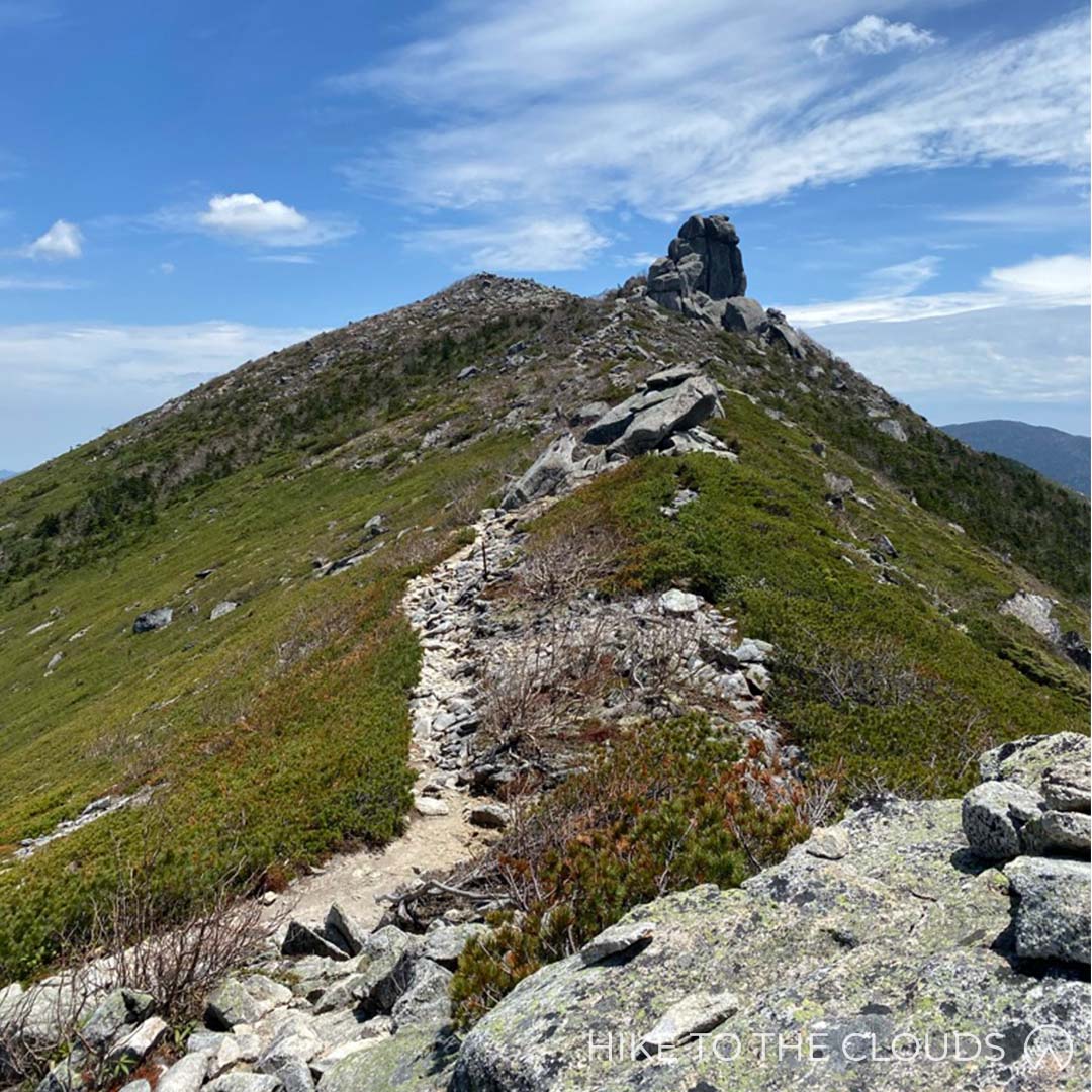
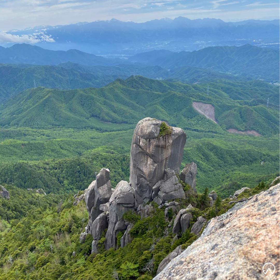
Mount Mizugaki is a fun peak for people who love scrambling over large rocks. As you start your hike, the awe-inspiring figure of the jagged mountain is enough to fill any hiker with a mix of trepidation and excitement. There are glorious 360 views from the summit, including a view over the ridge leading to Mount Kinpu. Mizugaki can easily be hiked in one day, but hikers often camp at the mountain's base and do a 2-day hike alongside Mount Kinpu.
百名山
Mizugaki Sansou Access
- Train and Bus
From JR Nirasaki Station on the JR Chuo Main Line, take the Yamanashi Kyohoku Kotsu bus bound for Mizugaki Sanso to the final destination, Mizugaki Sanso (about 1 hour and 10 minutes).
- Car
From the Sudama IC of the Chuo Expressway, take Prefectural Route 23, passing through Masutomi Onsenkyo to the parking lot around Mizugaki Sanso (120 cars free of charge). Around 35 minutes from the Sudama IC.
Mizugaki Yama Shizen Koen Access
- Car
Head to the Mizugaki no Mori Koen Shibafu Hiroba Car Park (みずがきの森公園芝生広場駐車場).
- Intermediate 中級
From Mizugaki Sansou. Up and back route.
- Time: 5h
- Distance: 5.4km
- Elevation Change: 720m
Mizugaki Sansou (瑞牆山荘) ~ (50m) ~ Fujimidaira Goya (富士見平小屋) ~ (30m) ~ Momotaro Rock (桃太郎岩) ~ (1h 30m) ~ 大ヤスリ岩 (the big rock in the picture) ~ Mount Mizugaki Summit (瑞牆山) ~ 大ヤスリ岩 ~ (1h) ~ Momotaro Rock (桃太郎岩) ~ (30m) ~ Fujimidaira Goya (富士見平小屋) ~ (40m) ~ Mizugaki Sansou (瑞牆山荘)
From Mizugaki Sansou head up the tril to Fujimidaira Hut where the path splits. Take the route to the left (the one on the right will take you towards Mount Kinpu). The path will take you up a sloap and then down towards a stream. After crossing the stream the trail opens up to a large open area with benches. In the clearing you will see a massive rock with a crack down the center. Momotaro Iwa is named after the Japanese childrens story of Momotaro. The trail continues up the steps to the right of the rock and takes you up ladders and ropes. Eventually you will reach the bottom of 大ヤスリ岩. Continue along the rhododendron-covered path. The path will get steeper and rockier as you get close to the summit. After admiring the 360 views at the top, head back down the way you came.
There are no toilets after the goya. So we recommend taking a break there and making sure you are prepared before starting up the mountain. If you are doing a two day hike pitch your tent at the goya and take a day pack with you.
Mizugaki Yama Shizen Koen Route 瑞牆山自然公園から
- Time: 6h
- Distance: 8.5km
- Elevation Change: 760m
Mizugaki Yama Shizen Koen (瑞牆山自然公園) ~ (40m) ~ End of Woodland Path (林道終点) ~ (1h) ~ Fudou Waterfall (不動滝) ~ (1h 40m) ~ Mount Mizugaki Summit (瑞牆山) ~ 大ヤスリ岩 (big rock in the picture) ~ (1h) ~ Momotaro Rock (桃太郎岩) ~ (30m) ~ Fujimidaira Goya (富士見平小屋) ~ (1h 10m) ~ Mizugaki Shizen Koen (瑞牆山自然公園)
From Mizugaki Sansou to Mount Kinpu.
For those doing a two day hike including Mount Kinpu.
富士見平小屋 ⇔ 大日小屋 ⇔ 大日岩 ⇔ 砂払ノ頭 ⇔ 千代ノ吹上 ⇔ 金峰山山頂
Toilets / Lodge
Toilets: There are toilets at the Mizugaki Sansou car park, Mizugaki Natural Park (if you are taking that route), and at Fujimidaira goya. You must pay to use the toilets. There are no toilets on the mountain itself. The Mizugaki Sansou toilets are closed through Winter.
Lodge and Campsite: Fujimidaira goya is a popular hut with a camping site 50 minutes hike from Mizugakisanso.
Fujimidaira Goya Website (Japanese)Mount Ryokami 両神山
- Area: Chichibu・Saitama (秩父・埼玉)
- Height: 1723m
- Yama to Kogen Map: No.26 雲取山・両神山 (Kumotori/Ryoukami)
Walking up Mount Ryokami in the Summer with green vines all around, you could imagine that Tarzan might come flying out of the trees to greet you. In May, the trail is sprinkled with pink rhododendrons.The verdant trail leads up to a curious rock formation at the peak, from where you can see over Oku-Chichibu and all the way out to Yatsugatake and the Northern Alps.
百名山
Mount Ryokami is accessible via car (* please read carefully) or train and bus
By car: For those taking the Hinata Oya Route. There is a free car park 日向大谷の駐車場 that can fit around 50 cars. The car park fills up quickly, especially on Saturday mornings.
By car: For those taking the Shiroisasushindo Route. The trail and car park are on private property. Spaces are very limited, and you must call and book in advance (in Japanese). Parking costs ¥1000, which also helps with the trail's upkeep. The owner will give you a map and explain about any dangers, such as recent animal spottings or route changes due to weather. The owners are lovely, but as they don't speak any English and have strong accents, they ask that people who take this route have a native speaker with them. Their main worry is that someone could get injured on their land because they haven't understood the explanation. This is a genuine concern as several people have died on the various Ryokami trails.
By train and bus or taxi: This is for the Hinata Oya Route. Take a train to Mitsumineguchi Station (三峰口駅); from there, take the 小鹿野町営バス to the last stop, Hinata Oya Guchi (日向大谷口). The ride takes about 48 minutes. It is also possible to get a taxi from the station to Hinata Oya Guchi.
- Intermediate 中級
Shiroisasushindo Route 白井差新道から (6h 25m)
We recommend taking this lesser trodden path for those who can book a space. To use this route, you must book in advance (Tel 0490-79-0494 Japanese only) and pay ¥1000 each towards the trail's upkeep. Carpark spaces are limited.
Shiroisasu Guchi (白井差口) ~ (1h) ~ Shiroisasu (白井差) ~ (1h) ~ Oodorigawara (オオドリ河原) ~ (30m) ~ Buna Daira (ブナ平) ~ (1h 10m) ~ Ryokami Peak (両神山) ~ (50m) ~ Buna Daira (ブナ平) ~ (20m) ~ Oodorigawara (オオドリ河原) ~ (45m) ~ Shiroisasu (白井差) ~ (50m) ~ Shiroisasu Guchi (白井差口)
The owner will explain where to park your car, give you a map, and explain the route along with any dangers (in Japanese). You may have to head up to the house if they aren't around the car parking area. There is a toilet in the parking area, which we recommend using before heading up. There are no facilities on the mountain itself.
The trail beginning of the trail is pretty relaxing, especially as you pass by Shoryu Waterfall. As you get to the steeper section, the path starts to zigzag. Once you reach the top, you will need to climb up a narrow pathway on the rock to reach the peak.
Hinata Oya Route 日向大谷から (6h)
Hinata Oya Guchi (日向大谷口) ~ (35m) ~ Kaisho (会所) ~ (1h 30m) ~ Kiyotaki Hut (青滝小屋) ~ (1h 20m) ~ Ryokami Peak (両神山) ~ (55m) ~ Kiyotaki Hut (青滝小屋) ~ (1h 10m) ~ Kaisho (会所) ~ (30m) ~ Hinata Oya Guchi (日向大谷口)
The first part of the course from the trail head isn't too tricky. After a while, the trail will get steeper and start zigzagging. After around 2 hours, you will reach a hut. The hut is currently closed, but there is a water area and toilet still in use. When you are ready, continue heading up to the summit. On the way, you will pass stone wolf statues there to protect the sacred shrine and mountain. Once you reach the top, there is a steep, narrow path along the rock up to the peak. This can get crowded on busy days. There isn't much space to eat lunch near the summit, but some hikers like to find perches on the rock ledges.
Toilets
Toilets: There are toilets in the carpark of the Shiroisasushindo Route. On the Hinata Oya Route, there are toilets around half way up the mountain at the Kiyotaki hut. There are no toilets at the peak.
Mount Tanzawa 丹沢山

- Area: Tanzawa (丹沢)
- Height: 1567m
- Yama to Kogen Map: No.29 丹沢 Tanzawa
Tanzawa is the King of the Tanzawa area. Although high-speed hikers and trail runners may be able to complete a round trip in one very long day, most people take two days. The most straightforward route takes you up Tonodake ridge, also known as Baka ridge. Baka means stupid in Japanese, and it is guaranteed that at some point on the mountain, you will feel like an idiot for deciding to hike it. The trail is made up of steep climbs followed by short flat sections, almost as if it were a staircase made for a giant. There are tons of steps on this mountain, which might be painful if you have a knee injury. The views both along the route and from the top are incredible. So no matter how much of an idiot you feel like while climbing the stairs to the top, you won't regret doing it. We recommend going in springtime when the trail is lined with cherry blossoms.
百名山
Tonodake is accessible via train and bus, or by car.
Train: From Shinjuku Station take the Odakyu Line train to Shibusawa Station (around 1h 20mins).
Bus: From Shibusawa Station take a Kanagawa Chuo Kotsu Bus to Okura (大倉) (around 15mins).
As always, make sure you check the last bus departure time back to the station.
Car: Depending on which route you plan to hike, you can park near Okura or Yabitsutoge.
- Intermediate 中級
Okura Route 大倉 (up and back)
- Total Time: 9h 25m
- Distance: 18.4km
- Elevation Change: 1277m
The route is well sign posted, all you need to do is follow the trail. The trail is popular, so if you are going on the weekend, you will only need to follow the stream of people. There are several tea houses on the trail up where you can stop for refreshments or food.
If you plan to do this route in two days, make sure to reserve your space at a lodge in advance.
- Day 1
- Time: 5h 25m
- Distance: 9.2km
From どんぐり山荘 head up the trail ~ (10mins) ~ to 大倉山の家 ~ (35mins) ~ 見晴茶屋 ~ (1h 20mins) ~ 小草平・堀山の家 ~ (25mins) ~ fork left (50mins) ~ 金鈴シ fork right ~ (25mins) ~ Tonodake Summit (塔ノ岳) ~ (1h 10m) ~ Hittaka (日高) ~ (30m) ~ Mount Tanzawa 丹沢山
- Day 2
- Time Down: 4h
- Distance: 9.2km
Do the same trail in reverse to go back down to Okura Carpark/bus stop
From Mount Tanzawa 丹沢山 ~ (20m) ~ Hittaka (日高) ~ (1h) ~ Tonodake Summit (塔ノ岳) ~ (15m) ~ 金鈴シ ~ (35m) ~ fork right ~ (15m) ~ 小草平・堀山の家 ~ (50m) ~ 見晴茶屋 ~ (30m) ~ 大倉山の家 ~ (5m) ~ どんぐり山荘・大倉
Trail Map from Hadano CityToilets / Tea Houses / Hut
Toilets: There are toilets at the car park, summit and at several tea houses on the way.
Tea Houses: There are 6 tea houses on the route up from Okura. They sell a variety of refreshments and food including, udon, soba and shaved ice (kakigori)
Huts: Miyama Sansou is the lodge at Mount Tanzawa peak. It is also possible to stay at Sonbutsu Sansou at the summit of Tonodake. You must book in advance.
Miyama Sansou Official WebsiteSonbutsu Sansou Official Website
北関東 Kita Kanto
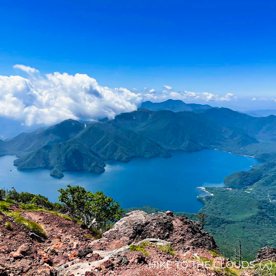
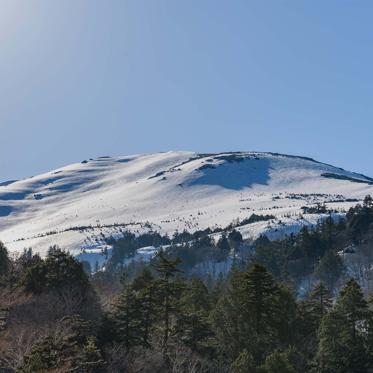
Mount Nantai (男体山)
- Area: Nikko (日光)
- Height: 2486m
- Yama to Kogen Map: No.13 日光 Nikko 白根山・男体山
Starting at UNESCO World Heritage Futarasan Shrine, head through bamboo forrests and up onto the sacred volcanic mountain. Nantai is an enjoyable but tough climb with incredible views over Lake Chuzenji. If you head up the trail early enough, you may be joined by monkeys who inhabit the area.
百名山
Access
We recommend going to Futarasan Shrine by car. For those who live far away, there are good campsites in the area.
Car: There is a carpark at Futarasan Shrine and spaces along the road in front of the shrine. Try to get there early as spaces fill up fast. The trail opens at 6:00am.
Train and Bus or Walk: Take a train to JR Nikko Station or Tobu Nikko Station. From either station there are buses to Futarasan Shrine. The bus ride is around 10 mins. Alternatively, walk 30~40 mins from the station to Futarasan Shrine.
- Intermediate 中級
From Futarasan Shrine
Time: 6~7h
Distance: 8km
When you arrive at the shrine you will be required to pay ¥1000 to use the trail.
You will be given a map and a charm to take with you.
The trail has 10 sections and each is marked with a stone marker. Each area is roughly 10% of the trail. Looking out for each marker helps you know how far you have come.
No toilets at the peak!
The only toilets are at the shrine at the start of the trail.
No benches or huts selling food
We recommend packing a bento to eat on the rocks around level 6, or at the peak.
There aren't any benches, but there are plenty of large rocks and bolders that make good resting spots.
Mount Shibutsu 至仏山
- Area: Oze (尾瀬)
- Height: 2228m
- Yama to Kogen Map: No.14 尾瀬 Oze
At 2228 meters Mount Shibutsu really does give you the chance to hike to the clouds, and the views over Oze's luscious wetlands make you feel as if you could be looking down from heaven. We recommend wearing boots with good grip on this mountain, as the trail is very slippery.
To find out more about Oze Region (Japanese)百名山
Shinkansen
Take the Joetsu Shinkansen from Tokyo Station to Jomo Kogen Station (1h 20 mins).
From Jomo Kogen Station, take a Kanetsu Kotsu bus to reach Togura (戸倉) (2 hrs). Change to a shuttle bus at Togura to get to Hatomachi Pass (30 mins).
Option 2: Take a train to Numata Station (沼田駅).
Once you arrive take a bus for Hatomachi-Toge 鳩待峠. Transfer to a shuttle bus at Togura (戸倉).
Oze Preservation Foundation Route Page (English)- Intermediate 中級
It takes around 3 hours to get to the top and another 2 hours or so to get down. Despite the relatively short hike (compared to some of the others on this page), and a well maintained easy to follow trail, we would describe this hike as challenging. The route is deceptively rocky with some areas needing chains to help you up. The rest of the trail consists of wooden stairs and a lot of wooden planks which become pretty slippery in wet weather. We have seen some of the most stunning slip and slides on this mountain even by the most experienced hikers.
There are two options to climb Mount Shibutsu.
Option 1: Climb up from the Yama-no-Hana trail and descend on the Hatamachi-Toge trail.
Option 2: Climb up from Hatamachi-Toge and retrace your steps back on the way down.
The Yama-no-Hana trail is used solely for ascent as the rocks make it dangerous for those descending (we would agree to disagree - but those are the rules). The trails are clearly marked in Japanese. For those who don't know the Kanji (and let's face it, even if you do know a lot of kanji, place names are difficult) 鳩待峠 (Hatamachi-Toge) / 山ノ鼻 (Yama-no-Hana). You may see a trail branching off partway up marked 笠ヶ岳 (Mount Kasa), don't take that route unless you want to go to a different mountain.
Toilets / Mountain Tea house / Visitor Centre
All amenities are at the Hatomachi-Toge rest area at the start of the trail. After that, you are on your own.
Mt Tsukuba 筑波山
- Area: Tsukuba / Ibaraki (筑波、茨城県)
- Height: 877m
- Yama to Kogen Map: No.20 赤城・皇海・筑波 Akagi / Sukai / Tsukuba
Known as "Shiho" or Purple Peak due to the way it changes colour at sunrise and sunset, Mount Tsukuba stands out against the backdrop of the flat Kanto plain. Unsurprisingly, it is considered one of Japan's greatest mountains, the saying goes "Fuji in the west, Tsukuba in the east" which goes to show how important Tsukuba is to the Japanese people. Unlike Fuji, Tsukuba is lush and teeming with wildlife all the way to the summit.
百名山
Mount Tsukuba is accessible via train and bus or by car
By Train: Take the very convenient Tsukuba Express from Asakusa to Tsukuba station.
Bus: Once you have arrived at Tsukuba station, take the shuttle bus going to Tsukuba Shrine. You can choose to get off at Tsukuba Shrine (45 mins) or get off at the Tsutsujigaoka bus stop (50 mins) depending on your chosen route.
Make sure you check the last bus departure time back to the station. Several hikers have been caught off guard and missed the last bus. If you do miss the bus, you will have to find a taxi company willing to pick you up from way out in the sticks, and it isn't cheap.
By car: There are carparks at both the Tsukuba-san Shrine Trail entrance and the Tsutsujigaoka trail entrance. Car park fees are ¥500 per day / ¥2000 for buses
Shuttle Bus Official Website (Japanese)- Beginner 初級
For those who are physically fit, Tsukuba won't feel too difficult. These routes are for fit beginners or lower intermediate hikers who don't want to use the cable car or ropeway.
Miyukigahara Course (2h 40m)
Tsukuba-san Shrine Entrance (筑波山神社入口) ~ (10m) ~ Tsukuba-san Shrine (筑波山神社) ~ (1h 15m) ~ Minanogawa Genryo (男女川源流) ~ (30m) ~ Tsukuba Summit (筑波山 山頂) ~ (25m) ~ Minanogawa Genryo (男女川源流) ~ (1h) ~ Tsukuba-san Shrine (筑波山神社) ~ (10m) ~ Tsukuba-san Shrine Entrance (筑波山神社入口)
Tsutsujigaoka Course (3h 55m)
Tsutsujigaoka Carpark (つつじヶ丘駐車場) ~ (50m) ~ Benkei Teahouse Ruins (弁慶茶屋跡) ~ (50m) ~ Nyotai-san Station (女体山) ~ (20m) ~ Tsukuba Summit (筑波山 山頂) ~ (20m) ~ Nyotai-san Station (女体山) ~ (40m) ~ Benkei Teahouse Ruins (弁慶茶屋跡) ~ (40m) ~ Tsutsujigaoka Carpark (つつじヶ丘駐車場)
Shirakumobashi Course Loop (4h 25m)
Tsukuba-san Shrine Entrance (筑波山神社入口) ~ (10m) ~ Tsukuba-san Shrine (筑波山神社) ~ (20m) ~ Bunki (酒迎場 分岐) ~ (1h 10m) ~ Benkei Teahouse Ruins (弁慶茶屋跡) ~ (50m) ~ Nyotai-san Station (女体山) ~ (20m) ~ Tsukuba Summit (筑波山 山頂) ~ (25m) ~ Minanogawa Genryo (男女川源流) ~ (1h) ~ Tsukuba-san Shrine (筑波山神社) ~ (10m) ~ Tsukuba-san Shrine Entrance (筑波山神社入口)
Loop Course From Tsukuba-San shrine (4h 35m)
Tsukuba-san Shrine Entrance (筑波山神社入口) ~ (10m) ~ Tsukuba-san Shrine (筑波山神社) ~ (20m) ~ Bunki (分岐) ~ (30m) ~ Tsutsujigaoka (つつじヶ丘駐車場) ~ (50m) ~ Benkei Teahouse Ruins (弁慶茶屋跡) ~ (50m) ~ Nyotai-san Station (女体山) ~ (20m) ~ Tsukuba Summit (筑波山 山頂) ~ (25m) ~ Minanogawa Genryo (男女川源流) ~ (1h) ~ Tsukuba-san Shrine (筑波山神社) ~ (10m) ~ Tsukuba-san Shrine Entrance (筑波山神社入口)
Trail CoursesCable Car / Ropeway / Restaurants / Toilets
Cable Car Fares
Adults: ¥590 (one way), ¥1070 (round trip)
Children (up to 15 years): ¥300 (one way), ¥540 (round trip)
Pet: ¥200 (each way), guide dogs ride free
Rope Way Fares
Adults: ¥630 (one way), ¥1120 (round trip)
Children (up to 15 years): ¥320 (one way), ¥560 (round trip)
Pet: ¥200 (each way), guide dogs ride free
6 years and under ride free
Pets must be put in special carry cases provided at the cable car station
Cable Car & Rope Way Set
For those who want to take the cable car up and the rope way down (or vice versa), this ticket will allow you one trip on each.
Adults: ¥1220 (round trip)
Children (up to 15 years): ¥620 (round trip)
Cable Car & Rope Way Set
For those who want to take the cable car up and the rope way down (or vice versa), and take a shuttle bus back to the carpark.
Adults: ¥1500 (round trip)
Children (up to 15 years): ¥750 (round trip)
Restaurants: There are several restaurants and souvenir shops.
Picnic Area: There isn't really a picnic area 'per se', but there are benches around the summit where you can sit and eat.
Mount Tsukuba Cable Car and Ropeway (English)Tanigawadake 谷川岳

- Area: Mikuni Mountains, Gunma (三国山脈 群馬)
- Height: 1977m
- Yama to Kogen Map: No.16 谷川岳 Tanigawadake
Gorgeous in all seasons, Tanigawa is a spectacular hike. The summit consists of two peaks Toma-no-Mimi and Oki-no-Mimi, just a 15-minute walk from each other along the ridge. But don't get lulled into a false sense of security while looking at the beautiful vistas, Mount Tanigawa is also known as Japan's Death Mountian, and is speckled with markers indicating where climbers and even some hikers died on the mountain. Hiking season runs from July to November, with ski resorts opening through the Winter.
百名山
Access
Mount Tanigawa is accessible via public transport or car.
- Public Transport
Shinkansen: Take the Joetsu Shinkansen from Tokyo Station to Jomo Kogen Station (about 1 hour 30 mins). From there take the Kan-etsu Kotsu Bus to the Tanigawa-dake Ropeway Doaiguchi Station (45 mins).
Regular Train: If you choose to take regular trains, buses are available from the JR Minakami Station, or you can walk (1.3km) from JR Doai station to the Ropeway station.
- Car
There is a multilevel car park at Tanigawa Ropeway. Parking costs between ¥500 ~ ¥1000 depending on car size and season.
There is another free car park near to Doai Bridge (土合橋) close to the Ichinokurasawa entrance. The car park is called Shiragamon Tozanguchi Parking Lot 白毛門登山口駐車場. It is about 15 minutes walk from the ropeway.
- Beginner 初級 ~ Experienced 上級
Tanigawa has a ropeway making it easier for less experienced hikers to reach the peak. With a variety of routes to explore, we have given each route its own difficulty level. Whichever trail you decide to take, never venture onto Tanigawa without proper preparation and research.
The hiking season runs from July to November and varies in length depending on when the trails are clear of snow.
Ichino Kurasawa Trekking Course
(一ノ倉沢トレッキングコース)
- Strong Beginner 初級
- Time: 2h 30m
- Distance: 6.9km
- Elevation Change: 307m
The Ichinokurasawa Trekking Course is a short loop trail that takes you through a beech forest and down by the river on the East side of Mount Tanigawa. With an elevation change of roughly 300m, it is a moderately challenging route for beginners. The full circuit takes around 2.5 hours to complete (without breaks).
FYI The Japanese sometimes use the word "trekking" to mean "walking". A lot of borrowed katakana words have different meanings in Japanese to their original English terms.
Hiking Route
From the Tanigawa Ropeway Base Plaza entrance, head towards the Tanigawa Mountaineering Museum on the left-hand side. A little further up from the museum is the Tanigawadake Mountaineering Guidance Centre (谷川岳登山指導センター). The centre has route maps and recent information about trail safety, so it is worth stopping in before heading to the main trail.
The trail starts out on a paved road lined with beech trees. There are benches at intervals and distance markers along the way.
After about 1 hour and a half you will come to Ichino Kurazawa Deai 一ノ倉沢出会. You will know when you reach it because you will be confronted with a 1000m high rock wall. This is one of the most famous and most dangerous climbing walls in Japan. There are toilets available in this area and hikers usually eat their lunch here. It can get a little bit chilly in this area due to glacial winds, a phenomena referred to as "breath of the glacier" in Japanese.
In peak season electric buses run between here and the trailhead, so if you are struggling, or have little ones who have had enough, it is possible to take the bus back. The bus costs ¥500.
From this point you will take an unpaved trail down towards the Yubiso River. After about 10~15 minutes you'll reach the river trail (清水峠越新道 しみずとうげごえしんどう), follow the path along the river. There is a point where you will need to cross the stream to the new trail. Keep going and you will eventually find yourself back at the ropeway.
Check out the loop route (yellow with red dots) next to the river on the map below.
Map PDFJapanese Map Notes:
The "分" symbol means "minutes" in Japanese, so 10分 means 10 minutes.
If there has been heavy rainfall, the lower section of the loop may be closed or difficult to pass. In this case, you may need to head back the way you came. On the map above there are some circled sections indicating where the water level may rise. "降雨時増水注意" means "Caution: water level may rise during rainfall".
Tenjin Ridge Route
- Low intermediate 中級
For a relatively short hike to the peak, take the ropeway up to Tenjindaira Station (1,320m). From the top ropeway station, it takes around 2 hours to hike to the summit (1,977m). It is also possible to take a pair lift up to Tenjintouge (1,500m). Both routes take around the same time.
Tenjidaira Top Ropeway Station (天神平駅 ロープウェイ) OR Tenjintouge Pair Lift Station (天神峠)~(45分)~ Kuma Anazawa Emergency Hut 熊穴沢避難小屋 ~ (30分) ~ Tengu No Tomariba (天狗の留まり場) ~(45分) ~ Tanigawadake Kata No Koya (谷川岳肩の小屋) ~ (10m) ~ Tanigawa Dake Toma No Mimi (谷川岳 トマの耳) ~ (15m) ~ Tanigawadake Oki No Mimi (谷川岳 オキノ耳) ~ (15m) ~ 谷川岳(トマの耳)~ (5m) ~ Tanigawadake Kata No Koya (谷川岳肩の小屋) ~ (45分)~ Tengu No Tomariba (天狗の留まり場) ~(30分)~ Kuma Anazawa Emergency Hut (熊穴沢避難小屋) ~(40分)~ Tenjidaira Top Ropeway Station (天神平駅 ロープウェイ)
Nishiguro Ridge Route
- Experienced 上級
- Time: 7h 10m
The 4.5 hour route from the lower Tanigawa Ropeway Station to Tanigawadake Kata No Koya up the Nishiguro Ridge is considered one of the steepest hiking routes in Japan. This route should never be attempted without the appropriate fitness level or preparation.
Nishiguro Ridge Trail Entrance (西黒尾根登山口) ~ (4h 30m) ~ Tanigawadake Kata No Koya (谷川岳肩の小屋) ~ (10m) ~ Tanigawa Dake Toma No Mimi (谷川岳 トマの耳) ~ (15m) ~ Tanigawadake Oki No Mimi (谷川岳 オキノ耳) ~ (15m) ~ 谷川岳(トマの耳)~ (5m) ~ Tanigawadake Kata No Koya (谷川岳肩の小屋) ~ (45分)~ Tengu No Tomariba (天狗の留まり場) ~(30分)~ Kuma Anazawa Emergency Hut (熊穴沢避難小屋) ~(40分)~ Tenjidaira Top Ropeway Station (天神平駅 ロープウェイ)
Tanigawa Ropeway Route Map (Japanese)Ropeway
- Tanigawa Ropeway Fare
Adults: ¥1250 (one way), ¥2100 (round trip)
Children: ¥630 (one way), ¥1050 (round trip)
- Tanigawa Ropeway Opening Hours
Between April and November:
On weekdays it is open from 8:00 ~ 17:00
On weekends and national holidays it is open from 7:00 ~ 17:00
Between December and March:
Everyday 8:30 ~ 16:30
Pair Lift
- Pair Lift Fare
All Riders (regardless of age): ¥420 (one way), ¥730 (round trip)
Official Tanigawa Ropeway page (Japanese)
Amakazariyama 雨飾山

- Area: Nagano / Nigata (長野県・新潟県)
- Height: 1963m
- Yama to Kogen Map: No.18 Myoko / Togakushi / Amakazari / Hiuchiyama / Takatsumayama / Shinetsu Trail
妙高・戸隠・雨飾 火打山・高妻山・信越トレイル
The mountain is characterized by its two peaks which people affectionately refer to as "cat's ears". The name Amakazari (雨 meaning rain) comes from the fact that an altar used to be enshrined at the top of the mountain to pray for rain. The summit is close to the Sea of Japan and offers a 360-degree panoramic view when the weather is clear. Major trails extend from Kotani in the south and Itoigawa in the north, both of which have hot springs.
百名山
Access to Amakazari Kogen 雨飾高原
Amakazari Kogen is reachable by public transport and car. Note that it is very difficult to do a day trip with public transport. We recommend staying at a campsite or lodge.
- Tain and Bus
Head to Minami-Otari Station 南小谷駅 then take a bus to Amakazari-Kogen 雨飾高原 (around 40 mins).
Bus Time Tables (2022)
Timetable PDF (The Minami-Otari Station is marked in yellow and Amakazari Kogen is the last stop)Timetable PDF (from Amakazari-Kogen to the Station)
Access Page By Otari Village Tourism Information
- By Car
Head to the Amakazari Kogen Camping Ground.
Access to Amakazari Sansou 雨飾山荘 / Amakazari Onsen
The Sanso is only accessible by car. If you want to take public transport the nearest bus stop is 7km away (Yamaderajyouiriguchi Bus Stop 山寺上入り口).
- By Car
There is a parking lot for about 25 cars in front of the hut, but if it is full, you need to park a little further down from the forest road.
Itoigawa IC > R148 > Neichi 74 line (根知 74号線) > Forest Road 山口 林道 > Hot Spring Lower Gate 温泉下ゲート > Amakazari Sansou 雨飾山荘
Amakazari Kogen Route
雨飾高原ルート
- Intermediate 中級
- Time: 7h 20m
- Distance: 13.4km
- Elevation Change: 1224m
If you are traveling by car, you can start and finish at the trailhead next to the Amakazari Kogen Campsite. This would knock about 1 hour and a half off of your overall time.
Amakazari Kogen (雨飾高原) ~(55m)~ Amakazari Trailhead (雨飾登山口) / Amakazari Kogen Campsite (雨飾登山口) ~ (1h 30m) ~ Arasugezawa (荒菅沢) ~(1h 20m) ~ Sasadaira (笹平) ~(5m)~ Trail Split 分岐 ~(30m)~ Mount Amazazari Summit (雨飾山) ~(20m)~ Trail Split 分岐 ~ (5m)~ Sasadaira (笹平) ~(1h)~ Arasugezawa (荒菅沢) ~(1h)~ Amakazari Trailhead (雨飾登山口) ~ (40m) Amakazari Kogen 雨飾高原
Take a look at the map here.
Yakushi Ridge Route
薬師尾根ルート
- Intermediate 中級
- Time: 7h 20m
- Distance: 6.4km
This route starts at Amakarari Sanso and Hot Springs (雨飾山荘) and takes you along a ridge from the opposite side to the Amakazari Kogen Trail above. The Yakushi-one course has an elevation difference of about 1,000 meters, and takes you on a STEEP climb up a narrow ridge. It is often snowy on the ridge right through to June, so if you are planning to hike during spring or early summer season, please check the trail conditions with Amakazari Sanso before your hike. There are ropes and ladders along some sections of the ridge.
There is a map of the route in English and Japanese near the Onsen at the trail head. The trail is sign posted in both English and Japanese, giving you a countdown of minutes until you reach the summit.
Take a look at this Youtube Video by やまおもしろい (Yamaomoshiroi) to get an idea of the steep trail up the ridge.- Toilets
There are toilets at Amakazari Kogen and Amakazari Trailhead.
- Campsites
Amakazari Campsite (Amakazari Kogen Route)
Amakazari Campsite is near the Amakazari Trailhead. It is possible to book online. If you aren't worried about booking in advance, they also have a feild available to hikers. Camping there costs ¥1320 and a portion of the fee goes towards maintaining the trail. The site holds up to 30 tents and cannot be booked in advance. They have a carpark that holds up to 70 cars.
Amakazari Campsite Website (interesting English)- Lodges
Amakazari So (Amakazari Kogen Route)
Amakazari So Website (Japanese)Amakazari Sanso (Yakushi Ridge Route)
Prices at the lodge start at ¥6400 per night without meals, add on ¥3100 for dinner and breakfast, ¥2100 for just dinner or ¥1200 with only breakfast.
You must check in before 15:00. Check out before 10:00am.
Amakazari Sansou Official Website (Japanese)Amakazari Sansou Booking Page (English)
Helpful Websites
Otarimura Tourist Information (machine translation on page)
To find the Amakazari Page > After changing the language to English, click on "Tourist Information is from here". On the next page, click on the grey mountains "& I Walk Climbs" button, scroll down to the "It's climbed" section, and then click on "Mt. Rainy Ornament" (a literal translation of 雨 rain and 飾 ornament).
Okushirane 奥白根山

- Area: Nikko (日光)
- Height: 2578m
- Yama to Kogen Map: No.13 Nikko Shirane / Nantai San 白根山・男体山
Oku-Shirane is an active volcano surrounded by onsen and famous for its many species of plants. It is not only the highest mountain in Nikko but the tallest mountain in the northern half of Japan.
百名山
Yumoto Visitor Centre Access
Yumoto Visitor Centre Access (English)Car: There is are carparks at Yumoto Onsen and Nikko Yumoto Visitor Centre.
Train and Bus: Take a train to (Tobu) Nikko Station, from there take a bus to Yumoto Onsen.
Sugenuma Access
Car: The Sugenuma Trailhead carpark (登山者用菅沼駐車場) can hold up to 70 cars and costs ¥1000. The tearoom car park near to Sugenuma Camp site (茶屋の駐車場) is free and holds up tp 100 cars.
Train and Bus: Take a train to (Tobu) Nikko Station, from there take a bus to Yumoto Onsen. Change at Yumoto Onsen for the bus to Sugenuma. The buses are scheduled so that changes are easy.
Nikko Shirane Ropeway Access
Car: There is a free carpark at Nikko Shirane Ropeway 日光白根ロープウェイ.
Train and Bus: Take a train to (Tobu) Nikko Station, from there take a bus to Yumoto Onsen, from there take the bus to Nikko Shirane Ropeway. The buses are scheduled so that changes are easy.
- Intermediate 中級
-
Yumoto Onsen ~ Mount Shirane (Loop)
- Time: 8h 40m
- Distance: 12.5km
- Elevation Change: 1091m
A challenging climb up steep scree slopes which aren't any easier coming down. Make sure to leave early and add in plenty of extra time for breaks. We recommend staying at one of the Yumoto onsen, or at the Yumoto Camp site the night before.
Yumoto Onsen (湯元温泉) ~ (2h 10m) ~ Gaizananbu (外山鞍部) ~ (1h) ~ Mae Shirane San (前白根山) ~ (1h 30m) ~ Mount Oku-Shirane (奥白根山) ~ (1h) ~ Goshikinuma Pond (五色沼池) ~ (40m) ~ Mae Shirane San (前白根山) ~ (2h) ~ Yumoto Onsen (湯元温泉)
Mount Oku-Shrirane from Yumoto Onsen Route Map and Official Guide PDF (English)Sugenuma Route
- Time: 4h 55m
- Distance: 7.1km
- Elevation Change: 956m
Sugenuma Guchi (菅沼口) ~ (1h 50m) ~ Midagaike (弥陀ヶ池) ~ (1h) ~ Nikko Oku-Shirane San (日光奥白根山) ~ (45m) ~ Midagaike (弥陀ヶ池) ~ (1h 20m) ~ Sugenuma Guchi (菅沼口)
Mount Oku-Shrirane Route Map and Official Guide PDF (English)Nikko Shirane San Ropeway Route
- Time: 4h 40m
- Distance: 7.1km
- Elevation Change: 709m
The easiest route to Oku-Shirane takes you takes you 2000m up via ropeway.
Sancho Station (山頂駅) ~ (45m) ~ Nanairodairaminamibunki (七色平南分岐) ~ (1h 45m) ~ Nikko Oku-Shirane San (日光奥白根山) ~ (45m) ~ Midagaike (弥陀ヶ池) ~ (35m) ~ Nanairodairakitabunki (七色平北分岐) ~ (35m) ~ 六地蔵 ~ (20m) ~ 山頂駅
Nikko Shirane Ropeway Route PDFNikko Shirane Ropeway Website (English)
Toilets / Onsen
- Toilets
Yumoto Onsen Route: There are toilets in the carparks near Yumuto Visitor Center.
Nikko Yumoto Restroom MapSugenuma Route: There are toilets at Sugenuma Camp Site (you may need to pay a fee), and in the carpark.
Ropeway Route: There are toilets at both ropeway stations.
- Onsen
Zazen Onsen (座禅温泉) at the bottom ropeway station.
Kamenoi Hotel Oku-Nikko-Yumoto (亀の井ホテル 奥日光湯元) is a popular onsen near to the Nikko Yumoto Visitor Centre.
Yumoto Onsen is a large area full of onsen. So it is important to find an onsen close to the Nikko Yumoto Visitor Centre.
- Helpful Websites
Mount Kusatsu-Shirane 草津白根山

- Area: Gunma 群馬県
- Height: 2160m
- Yama to Kogen Map: No.17 志賀高原 草津白根山・四阿山
Due to recent volcanic activity, it is currently not possible to hike to the summit of Mount Kusatsu-Shirane. All trails are currently closed.
Mount Kusatsu-Shirane is a sprawling volcano well-known among hikers for it's three stunning crater lakes at the summit. The mezmarizing turqoise green Lake Yugama, is said to be one of the most acidic lakes in the world.
百名山
Access
- By Train & Bus
Bus services to Kusatsu-Shirane are currently suspended. (Updated September 2022)
Buses usually run between July 1st ~ October 31st.
Bus Timetable (Japanese)
- By Car
The carpark and road to the mountain is still restricted due the the erruption in 2018. (Updated September 2022)
On March 23, 2021, the volcanic alert level for Mount Shirane was lowered from 2 to 1. However, the Shirane Resthouse and Car Park remain closed for the time being. We will keep you updated of any changes.
- Beginner 初級
- Time: 4h
- Elevation Change: 509m
All Trails are currently closed (Updated September 2022)
Shirane Kazan (白根火山) ~ (20m) ~ Yukamanishigawatenboudai (湯釜西側展望台) ~ (15m) ~ Shirane Kazan (白根火山) ~ (20m) ~ Ainomine (逢ノ峰) ~ (15m) ~ (旧コマクサリフト乗り場) ~ (1h 20m) ~ Tanshohodosaikochiten (探傷歩道最高地点) ~ (20m) ~ Motoshiranesan Tenbosho (本白根山展望所) ~ (20m) ~ Kagamiike (鏡池) ~ (35m) ~ sanchoeki (旧山頂駅) ~ (15m) ~ Shirane Kazan (白根火山)
From the bus stop, make your way around the car park and up left of the service centre to Yukamanishikawatenboudai (湯釜西側展望台). From there, you will get a view over Yukama crater lake. After taking photos (or just enjoying the scenery), head back down towards the car park. This time head in the other direction towards Ainomine (逢ノ峰). Keep going for another 15 minutes to reach Komakusa Lift (旧コマクサリフト). Komakusa is a pretty pink flower native to mountains in Japan. Some say the flowers look like horses' heads. From here, walk along the ridge and up to the right to Tanshohodosaikochiten (探傷歩道最高地点). Head back down from Tanshohodosaikochiten (探傷歩道最高地点) the way you came and Motoshiranesan Tenbosho (本白根山展望所). On a clear day, you should be able to see another 百名山, Hotakayama (武尊山). From here, you will start the loopback towards Shirane Kazen. Head down towards Kagamiike (鏡池 mirror pond); you will need to turn off the main path to see it up close. After, head towards Sanchoeki (旧山頂駅). Keep on going for another 15 minutes, and you will arrive back at Shirane Kazen.
Helpful Resources
- Helpful Phone Numbers
JR Bus Kanto: 0279-82-2028
Kusatsu Koutsu Bus: 0267-42-2441
- Helpful Websites
Akagi Yama 赤城山
- Area: Gunma (群馬県)
- Height: 1828m
- Yama to Kogen Map: No.20 Akagi 赤城・皇海・筑波 榛名山
Akagi-Yama is a dormant stratovolcano with a large caldera lake just 2 hours from Tokyo on the Kanto plains. Its beauty has turned the area into a popular tourist destination and resort with activities all year round, including swan boating in the Summer and wakasagi ice fishing in the Winter. There are several popular campsites, inns and onsen in the area. The most popular hiking seasons run from early Summer, when the azaleas are in bloom and Onuma lake turns an incredible turquoise blue, to Autumn, when the whole area turns to reds and golds. Mount Akagi has been the object of worship since ancient times, and the vermillion red Akagi Shrine has become an iconic symbol on the lake.
百名山
Access
Train and Bus: Take a train to Chuo-maebashi station via Joma Electric Railway, then take a bus (around 60 mins) to Mount Akagi Visitor Center bus stop.
(Option 2) Take a train to Maebashi Station on the JR Ryomo Line, then take a bus (around 60 mins) to Mount Akagi Visitor Center bus stop.
Car: Take the Maebashi IC or Akagi IC of the Kan-etsu Expressway from Tokyo to Akagi Prefectural Park Visitor Center. There are a number of carparks in the area.
Akagi Trip Access Webpage (Enlgish)
- Beginner 初級
Kurobi / Komagatake Course 黒檜山・駒ケ岳コース
- Time: 4h 20m
- Distance: 6.5km
- Elevation Change: 575m
Visitor Center (ビジターセンター) ~ (15m) ~ Akagi Hiroba (あかぎ広場) ~ (15m) ~ Akagi Shrine (赤城神社) ~ (10m) ~ Kurobi San Trailhead (黒檜山登山口) ~ (1h 30m) ~ Mount Kurobi (黒檜山) ~ (45m) ~ Komagatake (駒ヶ岳) ~ (45m) ~ Komagatake Trailhead (駒ヶ岳登山口) ~ (40m) ~ Visitor Center (ビジターセンター)
From the visitor center, head down towards the lake. Once you reach the lake, head up the right side (with the lake on your left) towards Akagi Shrine. Feel free to head over the bridge and explore the shrine.
Once you are finished looking around, keep heading up the side of the lake. The trailhead is a little difficult to see, it will be on your right, about 10 minutes up the road from the shrine. Be careful when crossing the road.
Follow the path for about one hour and a half and you will come to a T section. At the branch, take a left up to the peak.
From the peak head back to the branch and keep going straight (the righ branch that you didn't take before).
Keep going straight along the ridge for around 45 mins until you reach Komagatake. There are a couple of fantastic view points along the way where you can get pictures of the lake and shrine.
After a while the trail will start to take you down a steep section with steps.
After coming out of the komagane trail head (駒ヶ根登山口), you have 2 options. Either head straight back to the Visitor Center, or (our recommendation) take a left up and around Kakumanbuchi Marsh (覚満淵).
Akagiyama Hiking Maps (provided by Maebashi Tourism & Convention Association)Akagiyama Hiking Routes Maps (provided by Maebashi Visitors Bureau)
Mount Azumaya 四阿山

- Area: Gunma / Nagano (群馬県・長野県)
- Height: 2354m
- Yama to Kogen Map: No.17 Shiga-Kogen Kusatsu-Shirane / Azumaya (志賀高原 草津白根山・四阿山)
Mount Azumaya is an enchanting hike in all seasons. In the Spring and Summer the mountain flourishes with thick lush forests and alpine blooms. Autumn is just as glorious, the oranges and golds stretching out all the way from the summit and across the Asama Plateau below. In winter the mountain turns into a shimmering wonderland, brilliant for breaking in your new snow shoes.
百名山
Access
- Train and Bus
The trailhead is a 45 minute walk from the nearest bus stop.
Take a train (or Shinkansen) to Ueda Station (上田駅). From Ueda station, take a bus for Sugadaira (菅平) and get off at the Sugadaira-Kogen bus stop (菅平高原). Walk 45 minutes to Sugadaira Bokujo (菅平牧場). There are signs from the bus stop directing the way.
- By Car
Head straight to Sugadaira Bokujyo (菅平牧場). The car park holds up to 70 cars.
Google Map- Intermediate 中級
- Time: 5h 35m
- Distance: 9.5km
- Elevation Change: 976m
This popular trail starts at Sugadaira Farm (bokujo means farm in Japanese). It is a working fam and there is an admission fee of around ¥200 to enter onto the farm.
Sugadaira Bokujo (菅平牧場) ~ (1h 15m) ~ Koazumaya (小四阿) ~ (1h 15m) ~ Nekodake Bunki (根子岳 分岐) ~ (15m) ~ Mount Azumaya (四阿山) ~ (10m) ~ Nekodake Bunki (根子岳 分岐) ~ (1h 10m) ~ Neko Dake (根子岳) ~ (1h 30m) ~ Sugadaira Bokujo (菅平牧場)
From the farm carpark, take the path to the right along the asphalt road. The main trail will appear on your left. The path will lead you into a forested area with a stream before twisting up towards Koazumaya (小四阿). Follow the trail along past Chuazuma (中四阿), this section is full of PUDs (pointless ups and downs), until you reach the split at Nekodake Bunki (根子岳 分岐). From there it is just 15 minutes to the summit. Once you reach the summit, head back down to the split and take a right (the oposite direction to the route you came up before), towards Nekodake 根子岳. Hikers often eat their packed lunches on Nekodake summit as it is so spacious. From there, make sure to take the correct trail back down to Sugadaira Farm.
The Sugadaira Bokujo loop is on the left side of the map below, not highlighted. You can see the starting point where the car park and toilets are marked.
Azumaya Area Hiking Map (provided by Gunma Sightseeing 嬬恋村の観光)Toilets
There are toilets in the carpark at Sugadaira Farm.
中央アルプス・南アルプス Central Alps / SouthernAlps
Kisokomagatake 木曽駒ヶ岳

- Area: Central Alps / Chuo Alps (中央アルプス)
- Height: 2956
- 2 Day Hike
- Yama to Kogen Map: No.41 木曽駒・空木岳
The highest peak in the Central Alps (also known as the Kiso Mountains). We recommend this mountain for beginners who are ready to try their first 2 day hike. Fun fact, the Kiso Mountains are reverse faults, meaning they were formed by the earths crust being compressed together along fault lines.
百名山
Mount Kisokoma is accessible via train and bus
By Train and Bus: Take a train to Komagane Station (駒ヶ根駅). Then take the Komagatake Tozan Bus (駒ヶ岳登山バス) to Shirabi Daira Station (しらび平駅) which is the bottom terminal of the Komagatake Ropeway (駒ヶ岳ロープウェイ). Take the ropeway up to Senjojiki Station (千畳敷駅).
By Car and bus: There is a free carpark at Suganodai Bus Center (菅の台バスセンター). From there take a Tozan bus to Shirabi Daira Station (しらび平駅).
Ropeway Access (English)Ropeway Official Website (English)
Ropeway PDF (English)
- Beginner 初級
Senjo-Jiki Route (2 Day Hike)
- Day 1
- Time: 1h 50m
- Distance: 1.9km
- Elevation Change: 688m
Senjo-jiki station (千畳敷駅) ~ (1h) ~ Houken Sanso Mountain hut (宝剣山荘) ~ (30m) ~ Mt. Naka-dake (中岳) ~ (30m) ~ Mt. Kisokoma-gatake (木曽駒ヶ岳)
We recommend staying at 頂上山荘 for the night. At the moment it is only possible to camp here, but it seems that it may be re-opened as a regular mountain hut at some point in the future. If you don't have a tent, don't worry! You can stay at Houken Mountain Hut. This hut is fantastic for watching the sunrise. You must book in advance.
- Day 2
- Time: 3h 20m
- Distance: 5.1km
Mt. Kisokoma-gatake (木曽駒ヶ岳) ~ Noga Ike Bunki (農ヶ池分岐) ~ Noga Pond (農ヶ池) ~ Houken Sanso Mountain hut (宝剣山荘) ~ enjo-jiki station (千畳敷駅)
Senjo-Jiki Route (there and back route)
- Time: 3h 35m
- Distance: 3.9km
- Elevation Change: 448m
Senjo-jiki station (千畳敷駅) ~ (1h) ~ Houken Sanso Mountain hut (宝剣山荘) ~ (30m) ~ Mt. Naka-dake (中岳) ~ (30m) ~ Mt. Kisokoma-gatake (木曽駒ヶ岳) ~ (45m) ~ Houken Mountain hut (宝剣山荘) ~ (50m) ~ Senjyo-jiki station (千畳敷駅)
Cable Car / Campsites / Onsen at trailhead / Lodges / Toilets
- Campsites
Komagane Family Vacation Village is a campsite near Suganodai Bus Center.
There are also also several sites here for pet owners. Including one with a private fenced in site where your dog can roam free.
Komagane Family Vacation Village Website (Japanese- Lodges
There are several lodges on Kisokomagatake. We recommend Houkensanso (宝剣山荘)
宝剣山荘 website (google translated site) Mountain Hut Official Website (Automated translation available on page)Ropeway Official Website (English)
Utsugidake 空木岳

- Area: Central Alps / Chuo Alps (中央アルプス)
- Height: 2864m
- Yama to Kogen Map: No.41 木曽駒・空木岳
While Utsugi is not an effortless climb, it is easy to get distracted from any discomfort by the incredible views stretching over the Northern Alps, Mt Norikura, Mt Ontake, the Yatsugatake mountain range, and, of course, the Southern Alps. Almost all the peaks of the Chubu region can be seen from Utsugi. For animal lovers, it is common to spot rock ptarmigans and cute little stoats along the route.
百名山
Access
Komagane Kogen Route - From Suganodai Bus Terminal 菅の台
By Train and Bus: Take a train to Komagane Station (駒ヶ根駅). Then take the Komagatake Tozan Bus (駒ヶ岳登山バス) heading for Shirabidaira (しらび平駅) to Suganodai Bus Terminal 菅の台バスセンター
By Car: There is a carpark at Suganodai Bus Center (菅の台バスセンター).
Shirabidaira Route
From Shirabidaira Ropeway Station to Suganodai
By Train and Bus: Take a train to Komagane Station (駒ヶ根駅). Then take the Komagatake Tozan Bus (駒ヶ岳登山バス) to Shirabi Daira Station (しらび平駅) which is the bottom terminal of the Komagatake Ropeway (駒ヶ岳ロープウェイ). Take the ropeway up to Senjojiki Station (千畳敷駅).
By Car and bus: There is a free carpark at Suganodai Bus Center (菅の台バスセンター). From there take a Tozan bus to Shirabi Daira Station (しらび平駅).
Ropeway Access (English)Ropeway Official Website (English)
Ropeway PDF (English)
- Experienced 上級
Komagane Kogen Route - From Suganodai Bus Terminal 菅の台
- 2 days
- Time: 13h
- Distance: 20km
- Elevation Change: 2014m
The most popular course to hike Utsugi-dake. This is a good one-night-two-days route for upper-intermediate to experienced hikers. The climb on the first day is over 8 hours without breaks, so make sure to start early. We recommend staying the night near the trailhead to make sure you are well energised for the hike ahead.
Day 1
Suganodai Bus Center (菅の台バスターミナル) ~ (1h 30m) ~ the end of a logging road (道終点) ~ (1h 20m) ~ Ikeyama koya Mountain hut (池山小屋) ~ (1h) ~ Masenagi (マセナギ) ~ (1h 30m) ~ Yonasawa-no-kashira (ヨナ沢の頭) ~ (1h 30) ~ Bunki (分岐) ~ (30m) ~ Komaishi (駒石) ~ (35m) ~ Utsughi-dake Peak (空木岳)
Day 2
Utsughi-dake Peak (空木岳) ~ (20m) ~ Komaishi (駒石) ~ (20m) ~ Bunki (分岐) ~ (1h) ~ Yonasawa-no-kashira (ヨナ沢の頭) ~ (1h 10m) ~ Masenagi (マセナギ) ~ (30m) ~ Ikeyama koya Mountain hut (池山小屋) ~ (45m) ~ the end of a logging road (池山林道終点) ~ (1h) ~ Suganodai Bus Center (菅の台バスターミナル)
Shirabidaira Route - Shirabidaira Ropeway to Suganodai
- 2 days
- Time: 14h
- Distance: 19.5km
- Elevation Change Up: 1346m
- Elevation Change Down: 3138m
Day 1
7h 17m
Shirabidaira (しらび平) ~ (7.5m ropeway) ~ Enjo-jiki station (千畳敷駅) ~ (20m) ~ Gokurakudaira (極楽平) ~ (1h 30m) ~ Nigorisawaomine (濁沢大峰) ~ (1h 40m) ~ Hinokiodake (檜尾岳) ~ (1h 50m) ~ Kumazawadake (熊沢岳) ~ (1h 50m) ~ Kisodonosansou (木曽殿山荘)
Day 2
6h 40m
Kisodonosansou (木曽殿山荘) ~ (1h 30m) ~ Mount Utsugi (空木岳) ~ (45m) ~ Bunkiten (分岐点) ~ (1h) ~ Yonasawa-no-kashira (ヨナ沢の頭) ~ (1h 10m) ~ Masenagi (マセナギ) ~ (30m) ~ Ikeyama koya Mountain hut (池山小屋) ~ (45m) ~ the end of a logging road (池山林道終点) ~ (1h) ~ Suganodai Bus Center (菅の台バスターミナル)
Kisokomagatake and Utsugidake
- 3 days
- Time: 17h 35m
- Distance: 23.5km
- Elevation Change: 2106m
Day 1
Senjo-jiki station (千畳敷駅) ~ (1h) ~ Houken Sanso Mountain hut (宝剣山荘) ~ (30m) ~ Mt. Naka-dake (中岳) ~ (30m) ~ Mt. Kisokoma-gatake (木曽駒ヶ岳) ~ Noga Ike Bunki (農ヶ池分岐) ~ Noga Pond (農ヶ池) ~ Houken Sanso Mountain hut (宝剣山荘)
Day 2
7h 17m
Houken Sanso Mountain hut (宝剣山荘) ~ (30m) ~ Gokurakudaira (極楽平) ~ (1h 30m) ~ Nigorisawaomine (濁沢大峰) ~ (1h 40m) ~ Hinokiodake (檜尾岳) ~ (1h 50m) ~ Kumazawadake (熊沢岳) ~ (1h 50m) ~ Kisodonosansou (木曽殿山荘)
Day 3
6h 40m
Kisodonosansou (木曽殿山荘) ~ (1h 30m) ~ Mount Utsugi (空木岳) ~ (45m) ~ Bunkiten (分岐点) ~ (1h) ~ Yonasawa-no-kashira (ヨナ沢の頭) ~ (1h 10m) ~ Masenagi (マセナギ) ~ (30m) ~ Ikeyama koya Mountain hut (池山小屋) ~ (45m) ~ the end of a logging road (池山林道終点) ~ (1h) ~ Suganodai Bus Center (菅の台バスターミナル)
Campsites / Onsen at the trailhead / Lodges
- Campsites
Komagane Family Vacation Village is a campsite near Suganodai Bus Center.
There are also also several sites here for pet owners. Including one with a private fenced in site where you dog can roam free.
Komagane Family Vacation Village Website (Japanese- Lodges
We recommend staying at the Kisodono Sanso (木曽殿山荘) located roughly 400m below the Utsugi peak.
Kisodono Sanso Official Website (Japanese)Another popular lodge on this route is Komaho Hutte (空木駒峰ヒュッテ)
空木駒峰ヒュッテ official website (Japanese)For the 3 day hike including Kisokomagatake
There are several lodges on Kisokomagatake they are manged by the same company. We recommend Houkensanso (宝剣山荘).
宝剣山荘 website (google translated site)Mount Ena 恵那山

- Area: Nagano / Gifu (長野県・岐阜県)
- Height: 2192m
- Yama to Kogen Map: No.41 木曽駒・空木岳 Kisokoma / Utsugi-dake
The furthest south of the Top 100 in the Chuo Alps, Mount Ena is not as easily accessed as the others. While the mountain has quite a history and is one of Japan's legendary holy mountains worshipped since the Nara period, it isn't as dramatically beautiful as the other Top 100 Mountains in the region. Many say that its simplicity is part of its beauty. We will leave that up to you to judge.
百名山
Access
Mount Ena is only accessible by car.
- By Car
The carpark at Misaka-Toge Pass is free but only holds around 10 cars. There are no toilets available.
Google Map Misaka-Toge Pass Parking areaThere are 2 carparks near the Hirogawa Trailhead taking roughly 50 cars. The spaces fill up quickly on holidays and hikers often park on the shoulder next to the gate. Toilets are available.
Google Map Hirogawara Trailhead Parking AreaMisaka-Toge Pass Trail 神坂峠ルート
- Intermediate 中級
- Time: 7h 50m
- Distance: 12.7km
- Elevation Change: 1336m
Kamisaka Toge means "Gods Pass / Gods Slope" and inks back to Moun Ena's holy heritage. This trail is the oldest and most trodden trail on Mount Ena.
Kamisaka Toge (神坂峠) ~ (45m) ~ Torikoshi Toge (鳥越峠) ~ (25m) ~ Ubanagi (ウバナギ) ~ (25m) ~ Obanyama (大判山) ~ (1h 10m) ~ Tengunagi (天狗ナギ) ~ (1h 25m) ~ Emergency Hut (恵那山山頂小屋) ~ (10m) ~ Mount Ena (恵那山) ~ (10m) ~ Emergency Hut (恵那山山頂小屋) ~ (1h) ~ Tengunagi (天狗ナギ) ~ (45m) ~ Obanyama (大判山) ~ (25m) ~ Ubanagi (ウバナギ) ~ (25m) ~ Torikoshi Toge (鳥越峠) ~ (45m) ~ Kamisaka Toge (神坂峠)
Hirogawara Trail 広河原ルート
- Intermediate 中級
- Time: 7h 15m
- Distance: 11.2km
- Elevation Change: 1041m
The Hirogawara Trail is the shortest and, in recent years, most popular trail to Mount Ena.
Please be extra careful on this trail in wet weather. In 2003, a hiker was dragged away when the Hontani River (本谷川) rose blocking their way back to the carpark.
Hirogawara Trailhead Parking Area (駐車場) ~ (40m) ~ Hirogawa Trailhead (広河原登山口) ~ (3h 40m) ~ ~ Mount Ena (恵那山) ~ (10m) ~ Emergency Hut (恵那山山頂小屋) ~ (10m) ~ Mount Ena (恵那山) ~ (1h 50m)~ Hirogawara Trailhead (広河原登山口) ~ (35m) ~ Parking Area (駐車場)
- Toilets
Toilets are available at the Hirogawara Trailhead Carpark and at the Summit Emergency Hut.
Toilets are only open between June and October.
北アルプス南部・八ヶ岳周り
Ougatou - Utsukushigahara 王ヶ頭, 美ヶ原

- Area: Nagano
- Height: 2034m
- Yama to Kogen Map: No.33 八ヶ岳 Yatsugatake / Utsukushigahara
Despite its height of 2034m, this mammoth mountain is great for hikers who are just starting out. Ougatou is pretty in the Summer when you can see lots of cows grazing in the area, but also fun in the winter. If you want to try out snowshoeing for the first time, the flat expanses make this a fantastic place to practice.
Read more about the 5 easiest top 100 百名山 mountains here百名山
Train and Taxi: The nearest train station is Matsumoto Station on the JR Chuo Line. For those staying at Ougatou Hotel, there is a free shuttle bus from the Matsumoto Station. If you aren't staying at the hotel, a taxi from the station to Utsukushigahara Car Park will cost around 1万 yen. On the way back, Alpico Buses run from Utsukushigahara Art Museum to Matsumoto Station. The ride takes 1h 40m.
Train and Bus: Alternatively, go in the oposite direction taking a bus from Matsumoto Station to Utsukushigahara Open-Air Museum.
Car: Leave the highway at the Matsumoto interchange in Summer or Winter seasons. In warmer seasons the Mountain is also accessible via the Okaya Interchange.
Helpful phone numbers
Matsumoto Taxi: 0263-331-141
Matsumoto City Tourist Information: 0263-322-814
Helpful Websites
Alpico Bus Utsukushigahara Plateau Guide (English Website)
- Beginner 初級
Utsukushigahara Kogen Car Park ~ (30m) ~ Ougahana (王ヶ鼻) ~ (30m) ~ Ougatou (王ヶ頭) ~ (30m) ~ Shio Kure Place (塩クレ場) ~ (10m) ~ Utsukushi no Tou (美しの塔) ~ (15m) ~ Yamamoto hut (山本小屋ふる里館) ~ (20m) ~ Utsukushigahara Open-Air Art Museum (美ヶ原美術館)
Toilets / Hotel / Open-air Museum
Toilets: There are toilets in the carparks.
Hotel: Ougatou Hotel sits at the summit. The perfect place for watching the sunrise and sunset on the mountain in comfort.
Ougatou Hotel Webiste (English)Open-Air Museum: Combining art and nature the Utsukushigahara Open-Air Museum has more than 350 sculptures. Situated on a 2,000-meter-high plateau, there are 360 views of the surroundin Japan Alps.
Utsukushigahara Open-Air Museum (English Website)Utsukushigahara Kogen Tourism Website (Japanese)
Yamato Goya Furusatokan Website (Japanese)
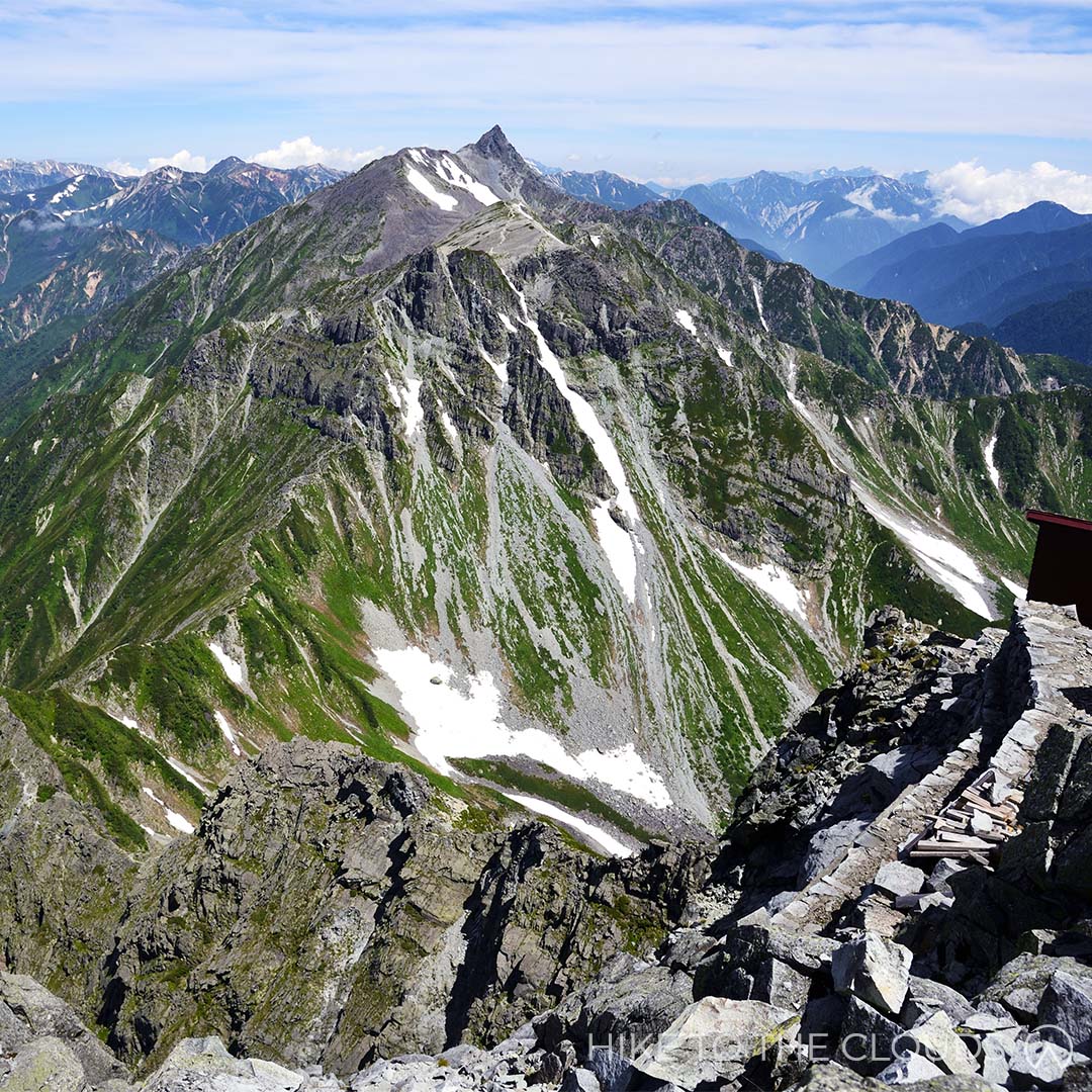
Mount Yari 槍ヶ岳
- Area: Hida Mountains, Northern Alps
- Height: 3180m
- Yama to Kogen Map: No.38 槍ヶ岳・穂高岳 上高地 Yarigatake
Mount Yari is the 5th tallest mountain in Japan and as such is a must hike on any experienced hiker's list. It takes it's name from the Japanese word for "spear" as it is said to resemble a spear peircing the sky. The most popular month to hike is August when the snow has melted.
Yarigatake Sansou Official Website (English)Kamikochi Resort Hotel Association Website (English)
百名山
Via Train and Taxi (Kamikochi Route / Yarisawa Route)
You can gain access to Kamikochi via train, but from there most hikers go by car to the trailhead. Taxis are available in the area
By Bus (Kamikochi Route / Yarisawa Route)
Some people hike from Kamikochi Bus Station to the Yoko hut (About 14km).
You can get a bus from Shinjuku Bus Station to 平湯温泉バス停 (4h 25 mins), from Hirayu Onsen take the Kamikochi line to Kamikochi bus terminal (25 mins). The bus company is called Nohi Bus. See the Nohi Bus link below for more details
Train and Bus (Shinhotaka Route)
Alpico has direct buses from Shinjuku Bus Station to Kamikochi bus Station.
Take a train/shinkansen/bus to Takayama Station (高山駅) in Gifu, take the bus bound for Shinhotaka Onsen (新穂高温泉) to the last stop (around 1h 30mins).
There are buses available from Shinjuku Bus Station to Takayama Station (5h 30mins).
Via Car (Shinhotaka Route)
There is free parking for hikers at the Ryokan Shinhotaka Okuhida. From there head up the road, past the ropeway, and another car park at the top of the hill to reach the trailhead. Maps are available at the lodge, but there are signs as well.
The Japan Alps Website (English) - for information on access via KamikochiNohi Bus (English) - for buses from Shinjuku Station
Alpico Group Buses (English) - for buses to Kamikochi from Shinjuku / Tokyo / Shibuya and other areas
- Experienced 上級
There are multiple Trailheads to Yarigatake Summit
Both the Kamikochi Route and Shinhotaka routes are very popular. The most difficult route from the Kamikochi side is along Yarihotaka Ridge.
Experienced hikers could also trek the Hotaka Peaks from the Gifu side along the Nishikama Ridge; or hike along the Higashikama Ridge (Higashikama-one) from the Nagano side
Kamikochi Route (Yarisawa Route)
Mt. Yari can be climbed from Kamikochi over the course of two or three days depending on your fitness level. Strong intermediate hikers should be able to complete this route without too much difficulty.
Once you reach the trailhead there are marks and signs to keep you on the right path
There are plenty of lodges along the way, but remember, most of them require reservations. Although some huts accept up to 3 hikers without reservation. See the link below for more information and basic route maps.
Easy 3 Day Example Itinerary
Day 1
Kamikochi Bus Terminal ~ Yokoo Campsite (3h)
Yokoo Campsite ~ Yarisaawa Lodge (1h 40mins)
Yarisawa Lodge
Day 2
Yarisawa Lodge
Tengu Pond
Mt Minamidake
Yarigatake Sanso Hut
Day 3
Yarigatake Sanso
Tokusawa Campsite
Kamikochi Bus Terminal
Yarigatake Sansou Group Website (English)Trekking from Kamikochi (English)
There are 4~5 huts along each of the most popular routes.
Yarigatake Sansou rents helmets to hikers going up to the peak
Yarigatake Sansou Group Website (English)Tateshina 蓼科山・北八ヶ岳
- Area: Northern Yatsugatake (北八ヶ岳)
- Height: 2531m
- Yama to Kogen Map: No.33 八ヶ岳 Yatsugatake
Tateshina is the most prominent mountain in Northen Yatsugatake. At an astonishing 2531m, the single-peak mountain has some of the most phenomenal unobstructed 360 views of all mountains in Japan. If you are able to stay at one of the lodges, the stars are astounding.
百名山
The Nanagoume Trailhead is accessible by car or via train and bus
By car: There is a free carpark near the trailhead that cat fit up to 100 cars (蓼科山七合目登山口駐車場)
By train and bus: First, head to Nagano's Chino station (茅野駅). Then take the Aplico Koutsu Bus heading for Shirakaba Lake (アルピコ交通バス 白樺湖・車山高原・霧ヶ峰線), get off at 東白樺湖(白樺湖バスステーション). The bus ride takes around 50 minutes. From Shirakaba Lake Station, take the Tateshina Smile Koutsu - Shirakaba Line (たてしなスマイル交通 シラカバ線)to Tateshina Bokujo 蓼科牧場, a roughly 10-minute trip. From there, take the gondola lift (蓼科牧場ゴンドラ) up to Gosensui Shizenen Station (御泉水自然公園駅). Nanagoume trailhead is a 20-minute walk from the gondola station.
アルピコ交通(白樺湖・車山高原・霧ヶ峰線)の時刻表 (Japanese)
Shirkaba Kogen Website with gondola information 蓼科牧場ゴンドラ (Japanese)
Tateshina Smile Koutsu (Click 英語 English on the google dropdown menu)
- Intermediate 中級
Due to its relatively short hiking time, Tateshina is popular among beginner hikers. But don't be fooled, this is no walk in the park. The hike will take you up an hour of unrelenting steep slopes followed by another 30 minutes of full-body scrambling. While this mountain is fantastic for fit beginners who like a challenge, we have added it to the lower-intermediate section as full hiking gear is necessary.
Nanagome Route 七合目登山口から (4h)
Easy enough for fit beginners, this hike is a good starting point for those who want to start hiking bigger mountains. The route is well signposted and easy to follow. Hiking season is between the end of April and the beginning of November. If hiking in April, May, October or November, you will need crampons for snowy areas.
Nanatome Trailhead (七合目登山口) ~ (1h 30m) ~ Shogundaira (将軍平) ~ (50m) ~ Mount Tateshina Summit (蓼科山) ~ (30m) ~ Shogundaira (将軍平) ~ (1h 5m) ~ Nanatome Trailhead (七合目登山口)
Start at the tori gate. Sometimes there are walking sticks next to the entrance that you can borrow. It is helpful if you don't have your own trekking poles or want to feel like a Gandalf. Also, remember, this is the last toilet point as there are no toilets along the trail.
The first section of the trail takes you through long grass (クマザサ bear grass). The path gradually gets rockier. After around 20 minutes, you will find yourself in a forest surrounded by alpine trees. The trail is clearly marked, so it is difficult to get lost. Keep following signs to 天狗の露地 (Tengu no Roji) and 将軍平 (Shogundaira).
The trail will start to get steeper, but you can use the view over Megami Lake (女神湖) as an excuse to stop for breaks. After around 40 minutes, you will come to Tateshina Sanso (Mountain Hut) and Shogundaira (将軍平). There is a junction here where the path from Ogawara Pass joins the main trail.
From the Sanso, take a right up the ridge. This section of the trail involves full body scrambling to the summit.
The top of the mountain is an open flat strewn with volcanic rocks. The summit boasts unobstructed 360 views. On a clear day, you can see the Yatsugatake mountain range, the Southern, Central, and Northern Alps, Mount Kirigamine, and Mount Asama. To say the view is impressive does not do it justice.
After taking photos, revelling in the hiker's high, and basking in the glory of completing another top 100 mountain, head back down the way you came with content in the knowledge that you are on your way to becoming a hiking master!
Toilets
There are toilets in the trailhead carpark. There are no toilets along the trail itself, so it is better to go before you start your hike.
There is a toilet at Tateshina Sansou between April 29th ~ November 5th. It costs ¥200 for each use.
Lodges
Tateshina Sansou: You will pass Tateshina Sansou (蓼科山荘) near Shogundaira (将軍平) on the way up to the summit. The lodge is open from April 29th ~ November 5th. It costs ¥6000 to stay the night, ¥7500 with breakfast included, ¥8500 with just dinner included, or ¥9500 with both dinner and breakfast inclued. Payment should be made in cash. To book call TEL : 090-1553-4500 (Japanese)
Tateshina Sancho Hutte: Tateshina Sancho Hutte (蓼科山頂ヒュッテ) can be found at the summit of Tateshina. The lodge is open from April 29th ~ November 5th, and has a special Open Day on New Years Eve. It costs ¥7000 to stay the night, ¥8500 with just dinner included, or ¥10000 with both dinner and breakfast inclued. Private rooms cost extra. Payment should be made in cash. To book call Tel: 090-7258-1855 or Email: info@tateshinayama.com
Tateshina Sansou Website (Japanese)
Tateshina Sancho Hutte Website (English)
Norikuradake 乗鞍岳

- Area: Nagano / Gifu (長野県・岐阜県)
- Height: 3026m
- Yama to Kogen Map: No.39 Norikura-Kogen 乗鞍高原
Mount Norikura (or Norikura Dake) comprises several mountain peaks in the Japanese Northern Alps. Norikura means horse saddle in Japanese, which, as you can see from the picture, describes its shape well. This pretty area is home to several ponds, lakes, and plateaus populated with wildflowers.
百名山
Access
Norikuradake is accessible from around mid-June to the end of October. Exact dates vary depending on weather conditions.
- Train and Bus
From Matsumoto Station
Option 1: Take a train from Matsumoto Station to Shinshimajima Station (30 minutes). From Shinshimashima Station (新島々駅) take a Norikura Line Bus.
Option 2: Take an Express Bus from Matsumoto Bus Terminal towards Hirayu Onsen 平湯温泉. From there take the Norikura Line to Norikura Sacho Tatamidaira 乗鞍山頂 畳平.
JR Matsumoto Station (JR松本駅) > Shinshimajima Station (新島々駅) > Alpico Koutsu Bus (アルピコ交通 バス 50m) > Norikura Kougen Tourist Information Centre 乗鞍岳高原観光センター > Alpico Koutsu Bus (アルピコ交通 バス 50m) > Norikura Summit / Tatamidaira (乗鞍山頂・畳平).
From Takayama Bus Center
From Takayama Bus Center take a bus to Hirayu Onsen. From there take the Norikura Line to Norikura Sacho Tatamidaira 乗鞍山頂 畳平.
Nohi Bus Timetables (English)Helpful phone numbers
Alpico 交通: 0263-922-511
Alps 交通 taxi: 0263-582-021
Alps Tourist Information: 0263-942-221
Helpful Websites
Alpico Group Bus Timetable and Routes (English)
Alpiko Bus/Train Timetable Matsumoto to Norikura Kougen (English)
Alpico Bus Timetables, Norikura Kougen to Tatamidaira (English)
- By Car
Private cars are not permitted to drive up Mount Norikuradake. Instead, travelers have to transfer to a bus at the base of the mountain (see bus details above). On the Nagano side, cars are allowed as far as Sanbondaki in Norikura Kogen. There are multiple free parking lots in the area, including a large one at the Kanko Center. On the Gifu side, drivers can park their car in Hirayu Onsen or at the Honokidaira parking lot outside of the town.
Head to Norikura kougen Tourist Information Centre (乗鞍高原観光センター). Take the 長野道松本IC > 国道158号 > 県道84号. Park at the 三本滝 Resthouse Carpark (free parking). From there you will either need to take the Alpico Koutsu Bus to the summit (50m), or take a taxi (around ¥9000), which you may need to book in advance.
Google Map (Norikura Kogen Visitor Center)
Norikura Visitor Center Access Page (English)
- Beginner 初級
- Time: 3h 10m
- Elevation Change: 451m
Tatamidaira 畳平 ~ (40m) ~ Katanokoya 肩ノ小屋 ~ (1h) ~ Kengamine (剣ヶ峰) ~ (40m) ~ Katanokoya (肩ノ小屋) ~ (30m) ~ Fujimidake (富士見岳) ~ (20m) ~ Tatamidaira (畳平)
From Tatamidaira car park, start towards Katanokoya (on the Kengamine Trail). It will take around 40 minutes to reach the hut. You may wish to use the toilets before moving onto the long stretch. From here, the terrain will get rougher as you head onto a natural hiking trail towards Mount Asahi and Kodamadake. At the top, you will have views over the cobalt-blue Kongenike (Kongen Pond). After admiring the pond, continue onto Chojyogoya (Chojyo Hut) and Kengamine. Once you reach the summit, you will be met with spellbinding 360-degree panoramic views over the Southern and Chuo Alps. When you are ready, head back along the trail that you came up until you get back to Katanokoya. From Katanokoya, head to Fujimidake via the wooded route. At the summit, you will be able to look back over the trail you took to Kengamine. From Fujimidake, it will take roughly 20 minutes to get back to the car park.
Map PDF (English)Norikura Trails PDF (Japanese)
Facilities
- Toilets
There are toilets in the carparks.
- Restaurants
There are a variety of restaurants and cafes around Norikura Kogen. Below is a PDF showing the different locations and opening times in English.
Norikura Kogen Restaurants PDF- Helpful Websites
Norikura-Kogen Visitor Center (English)
Norikuradake Tourism Association Website (English)
Ontake 御嶽山

- Area: Gifu / Nagano (岐阜・長野)
- Height: 3067m
- Yama to Kogen Map: No.40 Ontake San (Kohideyama / Okusangaidake) 御嶽山 (小秀山・奧三界岳)
Ontake is one of Japan's most revered mountains. It is the second highest volcano (Mount Fuji being the first) and the 14th highest mountain in Japan. You will climb up alongside pilgrims who come from all over Japan to worship, passing shrines, tori gates and religious statues on your ascent. There are outstanding views on a clear sunny day, and the crater ponds appear blue.
Ontake is still active, so it is imperative that you check volcanic alerts before hiking. Helmets are recommended while on the mountain. The last eruption in 2014, took the lives of 58 hikers and lodge staff.
百名山
Ropeway / Kurosawa Trailhead Access
Car: Head to the Ontake Ropeway carpark (御岳ロープウェイ鹿ノ瀬駅の駐車場). The carpark is free and holds around 1500 cars.
Train and Bus: Take a train to Kiso-Fukushima Station (木曽福島駅). From the station take a bus to Ontake Ropeway (御岳ロープウェイ).
Find the timetable PDFs on the ropeway access page below.
Ontake Ropeway Access Webpage (Japanese)
- Intermediate 中級
Ropeway / Kurosawa Trailhead
- Time: 5h 30m
- Distance: 7.6km
- Elevation Change: 1020mm
Don't be fooled by the short hiking time. This hike involes is 2 hours of solid stair climbing.
Ontake Ropeway Top Station (御岳ロープウェイ飯森高原駅) ~ (10m) ~ Seventh Station (七合目) ~ (1h 10m) ~ Nyonindo (女人堂) ~ (1h 25m) ~ Ninth Station (九合目) ~ (35m) ~ Ontake Shrine and Summit (御嶽神社奥社) ~ (25m) ~ Ninth Station (九合目) ~ (50m) ~ Nyonindo (女人堂) ~ (45m) ~ Seventh Station (七合目) ~ (10m) ~ Ontake Ropeway Top Station (御岳ロープウェイ飯森高原駅)
After exiting the ropeway, take the woodchip trail to the left. At the end of the path turn up right towards the Seventh Station. Head up steps through a wooded area and you will arrive at a lodge with a shrine on the right. After passing the lodge, keep heading up for about an hour until you reach the Nyonido lodge. There is a picnic table outside the lodge, which is a nice place to take a brake and have lunch. From Nyonindo, you will head up some steps and past a series of religious statues. After a while the trail will open out onto an open rocky slope leading up to Ishimuro Sanso. Once you reach the Sanso, you will need to walk through the lodge and out the other side. From there it is another 35 minutes up to the shrine and summit.
If the siren sounds at any point on your hike, head down the mountain to the nearest shelter. Most hikers wear helmets on the mountain, and some bring protective masks and goggles to protect themselves from volcanic gas. We recommend wearing a helmet at minimum.
Toilets / Lodges / Campsite / Restaurant
- Toilets
There are toilets at the Ropeway Stations. There are toilets at the lodges, but you may be charged to use them.
- Restaurants
There is a restaurant at the top gondola station.
- Campsite
There is a camp site next to the lower ropeway station. The campsite is run from the shop inside the main ropeway building. It costs 2000 per person and at the moment there are minimal facilities (2022). We recommend bringing strong tent pegs and somthing to hammer them in, as the ground is hard and riddled with rocks.
- Lodges
There are several lodges on Mount Ontake which are open through peak season (July to mid October).
- Ontake Nyonindo 女人堂
Nyonindo is at the Eighth Station and can sleep up to 80 people. Price range from ¥6000 to stay the night to ¥9500 including dinner and breakfast.
Ontake Nyonindo Webpage (Japanese)- Ishimuro Sanso 石室山荘
Ishimuro Sanso (石室山荘) sits just below the Ninth Station, and can sleep up to 100 people. Prices range from ¥7000 to stay the night, and ¥10000 with dinner and breakfast included.
石室山荘 Webpage (Japanese)Mount Ontake Ropeway Website (Japanese)
Ontake Spiritual Road Website (Japanese)
Kirigamine 霧ヶ峰

- Area: Nagano (長野県)
- Height: 1925m
- Yama to Kogen Map: No.33 Yatsugatake Tateshina / Utsukushigahara / Kirigamine 八ヶ岳 蓼科・美ヶ原・霧ヶ峰
Our favourite Top 100 Mountain for beginners. The area, which is a mixture of grasslands and marshlands, is home to over 600 species of flora, the most spectacular being the yellow Daylilies that blanket the plains during the Summer months. Hikers often spot foxes, weasels, deer, butterflies and rare birds on their outings. From Kurumayama - the highest peak, there are 360° panoramic views looking over the Northern, Central and Southern Japanese Alps.
百名山
Access
- By Train and Bus
By Train and Bus 1: Head to Chino Station 茅野駅. Then take the Alpico Bus アルピコ交通 to Kuruyama Kata(1h 5m).
By Train and Bus 2: Head to JR Kami-Suwa Station 上諏訪駅. Then take the Alpico bus アルピコ交通 (40m) to Kurumayama Kata.
By Train and Taxi: Head to JR Kami-Suwa Station 上諏訪駅. A taxi from Kami-Suwa Station takes about 30m and costs around ¥6000.
By Train and Bus 3: Head to Sakudaira Station 佐久平駅. For those coming from Tokyo it is reachable via the Nagano Shinkansen (1h 10m). Then take a bus (1h 30m) to Kurumayama Kogen.
- By Car
Head to Kurumayama Kata 車山肩. Take the Suwa I.C 諏訪IC > National Road 20 国道20号 > Prefectural Road 40 県道40号. There is a free carpark.
- Helpful Websites
Kurumayama Kogen (Official English Website)
Kuruyama Kogen Access Page (English Website)
Nihonmatsu Tourism Federation (Japanese)
- Helpful Phone Numbers
Alpico Bus: 0266-72-2151
Alpico Taxi: 0266-71-1181
Suwa Tourist Information: 0266-52-2111
- Beginner 初級
- Time: 4h 40m
- Elevation Change: 480m
Kurumayama Kata (車山肩) ~ (45m) ~ Kurumayama (車山) ~ (45m) ~ Chochomi Yama (蝶々深山) ~ (1h) ~ Okukiri Goya (奥霧小屋) ~ (30m) ~ Yashimaenchi (八島園地) ~ (40m) ~ Hutte Misayama (ヒュッテみさやま) ~ (20m) ~ Sawatari (沢渡) ~ (40m) ~ Kurumayama Kata (車山肩)
From the Car Park head up through Kurumayama Kata to Kurumayama (車山). Kurumayama is the prominent peak and Top 100 Mountain (百名山), at the top there is a Radar Dome (レーダードーム) and a stand which points out noteworthy mountains and landmarks visible from the summit. When you are finished admiring the view, it is time to head down past the Kurumayama marshlands and onto the next peak, Mount Chochomi (蝶々深山 (For those who don’t speak Japanese, chocho means butterfly - probably named after all the stunning varieties found in the area). From there, head down the stony trail and past the Monomi Iwa rocks (物見岩) to Okukiri Goya (奥霧小屋). There is a deer gate here that you will need to go through. The sign says to make sure to shut the gate again after you have passed through. You will pass a large pond and come out into another marshland (Yashima Pond 八島ヶ池). After walking for around 30 minutes on the wooden path, you will arrive at Yashima Enchi (八島園地). This is a great place to take a break and eat lunch. There are several huts, a cafe, toilets, and a visitor centre where you can learn more about the nature in the area. Once you are sufficiently rested, it is 40 minutes to the next hut (ヒュッテみさやま which also has toilets), and a little shrine. From the hut, it is 20 minutes to Sawatari (沢渡), and from there, you are on the home stretch. Head up the road to reach your final destination (and starting point), Kuruyama Kata.
Lodge / Campsite / Restaurant
- Restaurant
There is a small giftshop with restaurant next to the carpark.
- Lodge
The cozy Misayama Hütte (ヒュッテみさやま) is more like a cute b&b than your traditional mountain hut.
The Hütte cafe and shop is also popular with hikers during the daytime.
Misayama Hütte Website (Japanese)- Campsite
There is a spacious campsite run by Suwa City 5 minutes down the road by car. It is possible to walk from the campsite to the peak. The campsite is low priced, clean, and pretty. If you have a Montbell membership you can get a further discount.
Mount Aka / Yatsugatake Range(赤岳・八ヶ岳)

- Area: Yatsugatake, Nagano, Yamanashi
- Height: 2899m
- Yama to Kogen Map: 33 八ヶ岳 Yatsugatake
Yatsugatake is an immense mountain range split into Northern and Southern regions. Akadake is the highest peak in the Yatsugatake Mountain Range and part of the Southern Region. While the Northern Region is lush and pretty, the Southern Region is majestic and awe-inspiring. Legend has it that Akadake once rivalled Mount Fuji in height. After a competition, the jealous Fuji smashed Akadake into pieces creating the mountains remaining today. Taking in the striking Akadake rising from the clouds, it is easy to see how the legend came about.
百名山
Access
Train and Bus / Taxi
Take the JR Chuo Line Limited Express train from Shinjuku Station and get off at Chino Station (2 h 10 mins). Take a Bus from Chino Station to Minotoguchi (around 40 mins). Go to the west exit bus stop (西口のバス停) and take the Minotoguchi Line (美濃戸口線).
NB: There are very few buses a day. If you plan to go using public transport we recommend staying 1 night on the mountain.
Check the timetable for the 9991 route from Chino 茅野駅 to Minotoguchi 美濃戸口 hereCar
Get off the highway at Kobuchizawa IC (小淵沢IC) ~ take national road 国道11 ~ follow the prefectural road 県道484
There is a carpark at Minotoguchi 美濃戸口 that is free. If you drive up to Akadake Sanso and Minotoguchi Sanso there are a further 2 carparks which can each take up to 70 cars. The parking fee is ¥1000 per day (subject to change by owners). While parking at the Sanso knocks 1 hour off your hike, the road is very rough. If your car is low to the ground you may have difficulties. We don't recommend driving up this road unless you have a 4 wheel drive.
- Intermediate 中級
There are multiple routes up to the Akadake Summit
While it is possible to do some of these trails in one day, we recommend staying 1 night on the mountain.
Akadake
Minotoguchi ~ (1h) ~ Akadake Sansou ~ (2h) ~ Akadake Kosen (赤岳鉱泉 this is our recommended camp site and lodge) ~ (45 min) ~ Gyojya Goya (行者小屋 another lodge with a camping area) ~ (1h) ~ crossroads between Amidadake and Akadake ~ (40 mins) ~ Akadake Summit ~ (20 mins) ~ Akadaketenbousou 赤岳天望荘 (Lodge on the ridge just below Akadake) ~ (5 mins) ~ Jizounokashira (地蔵の頭 a signpost with a Jizo Statue) ~ (1h 5 mins) ~ Gyojya Goya ~ (40 mins) ~ Akadake Kosen (赤岳鉱泉) ~ (1h 30 mins) ~ Akadake Sansou ~ (50 mins) ~ Minotoguchi
Start at Minotoguchi, head to Akadake Sanso on the road. From Akadake Sanso take the left trail for 2 hours along a river until you reach Akadake Kosen (赤岳鉱泉). We recommend pitching your tent here (or checking in at this lodge), deposit your large bag switch to a day pack. Don't forget your helmet. Next take the route to the right of sansou. Go past the toilets and the trail will be in front of you. After around 45 minutes you should reach Gojya Goya, another popular lodge in the area.
Just before arriving at the hut, there will be a sign that will tell you to take a path up left to Aka-dake, ignore it. Instead, go through the campsite and up left on the other side. Keep going until you reach some steep stairs. Once you reach the top of the stairs Amidadake will be on your right, head left towards Akadake. Make sure you have your helmet on, this time there are steep rocks. You will have to use your hands and climb a bit to get to the peak. There are some areas with chains and ladders towards the top.
After admiring the view and maybe having some lunch (the best spot is behind the shrine), head over and past the sanso, then down. There are some tricky sections here, including a ledge that is pretty tight. Once you are over the rocks head down the steep zig zag path. Don't get cocky, it is worth keeping hold of the chain here, anyone can slip. Akadaketenbousou (赤岳天望荘) will be infront of you (we got our badges here). Walk on a little further until you reach a signpost with a Jizo statue. Take the path down to your left. This path is currently under construction (2022) but it is possible to get down. You will end up back on a steep trail surrounded by trees which will lead you back to Gyojya Goya (行者小屋). From the lodge retrace your tracks (trail to the right) back to Akadake Kosen where you can spend the night, or head back down to the trailhead if you prefer.
There are several lodges and campsites along each of the most popular routes. We recommend Akadake Kosen 赤岳鉱泉. The staff are friendly and welcoming, and the food is delicious.
There is drinking water available at both Akadake Kosen and Gyojya Goya.
There are toilets at the lodges which you may need to pay to use.
北アルプス北部
Mount Tsurugidake 剱岳

- Area: Kita Alps (北アルプス)
- Height: 2999m
- Yama to Kogen Map: No.37 剱・立山 Tsurugi/Tateyama
Another of Japan's most dangerous mountains. Despite claiming fewer lives than the infamous Mount Tanigawa, Tsurugidake is the mountain for thrill-seekers. This mountain is a cross between climbing and hiking as it would be impossible to get up the vertical rock faces without the use of the ladders and chains anchored to the edge of the cliffs. If sidling along a ledge with a 2000 metre drop below you sounds like fun, then this is the mountain for you!
百名山
Tsurugidake is accessible by train, funicular (cable car) and bus.
Take the Hokuriku Shinkansen from Tokyo Station to JR Toyama Station (around 2 hours). From there it's about a 10 min walk to Dentetsu Toyama Station where you can take the Toyama Chiho Tetsudo train to Tateyama Station (around 1 hour).
Once at Tateyama Station, take the Tateyama Cable Car to Bijodaira Station (7 mins). After that, take the Tateyama Kogen Bus to Tateyama Murodo (around 50 mins).
- Experienced 上級
- Days: 2+
Tsurugidake has a variety of routes for varying abilities. Advanced routes start in Chihirou Valley or Heizou Valley. Healthy and athletic beginners can tackle trails starting in Hayatsuki or Bessan; However, even the lower level trails include dangerous areas with ladders and chains, so we wouldn't advise this course for anyone but the physically fit. Likewise, if you have a paralysing fear of heights, you may wish to hike elsewhere or stop at the first "fake" summit at 1500 meters above sea level. Further up there are areas where you will be clinging against the edge of a mountain, with nothing but a chain to grip hold of.
The Murodo Route: The most popular route starts at the Murodo bus terminal, is around 14.4 km and takes roughly 12 hours 40 mins (without breaks). You will need to book a mountain hut for a one night stay.
Murodo bus terminal ~ (55 mins) ~ Raicho-daira ~ (1h 50 mins) ~ Bessan-Nokkoshi/Bessan-Pass (This is where the camp site and mountain huts are) ~ (1h 5 mins) ~ Kenzan-so ~ (30 mins) ~ Ippuku-tsurugi ~ (40 mins) ~ Zenken ~ (1h 20 mins) ~ Mt. Tsurugi ~ (1h 20 mins) ~ Zenken ~ (40 mins) ~ Ippuku-tsurugi ~ (20 mins) ~ Kenzanso ~ (1h 40 mins) ~ Betsuzan-nokkoshi ~ (1 hour 10 mins) ~ Raicho-daira ~ (1 hour 20 mins) ~ Murodo bus terminal
From Murodo to Raicho-daira - The first 30 minutes or so will take you on a well maintained paved footpath past the Mikuriga and Rindo ponds. The second stretch is 25 minutes of stair climbing. From Raicho-daira, walk up a rocky slope through some fields, and yet another rocky area to get to Bessan-nokkoshi (Bessan Pass), this is where you will find the first mountain hut (Tsurugi-gozen-goya). Keep going down a rocky slope (and past the camping grounds) to get to the second mountain hut (Tsurugi-sawa). Walk another 20-30 minutes through the stone pine belt to get to the Kenzan-so mountain hut, the third and final mountain hut. The next section is where it gets tricky...and dangerous. After walking up to the Ippuku-tsurugi peak, there is a long chain section to Mae Tsurugi. From there, a steep incline with narrow ledges and chains, followed by more ladders and chains. In high season, hikers may wait for up to an hour to get through these tricky sections. The path splits off into 2 routes, one for ascent and one for descent. On the pathway up you will come to Kani-no-tatebai and on the route back down Kani-no-yokobai. Kani-no-yokobai means walking sideways like a crab, and refers to the sections where you need to shuffle sideways along a narrow ledge while holding a chain to keep you on the mountain. Kani-no-tatabi means crawling upwards like a crab. After climbing Kani-no-tatabi you will get to a gentler slope leading up to the summit. Congratulations! You made it!
Deaths do occur every year on Tsurugidake, please make sure to prepare well for any hike you undertake on this mountain. It is incredibly important to stay on established trails and watch out for sudden dropoffs.
Mount Tateyama: For those who wish to admire the gorgeous nature without breaking a sweat (or the fear of death), there is also the option of doing the Tateyama Kurobe Alpine (pronounced Alpen) Route, a popular sightseeing tour using coaches, cable cars and trolleybuses with only 15 minutes on foot. The route is sometimes referred to as "the roof of Japan" as passengers pass through the stunning scenery of the Japanese Alps.
Tateyama Alpine Route Website (English)Mountain Huts / Camping Ground
The huts are usually open between the end of July and the end of October. Note that if you plan on staying in the mountain huts, you usually need to reserve your space in advance.
The Tsurugi-gozen-goya mountain hut is on the Bessan Pass. It takes around 2 hours 50 minutes to get there from Murodo.
The Tsurugisawa-goya mountain hut is a further 1-hour hike down the slope from the Bessan Pass, past the camping ground.
Rates and info
One night + 2 meals: ¥12000
One night + dinner: ¥11000
One night + breakfast: ¥10000
Sleep only (no meals): ¥8000
Packed Lunch: ¥1000
The Kenzan-so mountain hut is further up the alpine trail close to the Ippuku Tsurugi peak (or the "fake" peak). It takes 2.5 hours to get to the true Summit from Kenzan-so.
Gonzen-Goya Mountain Hut Official Website (Japanese)Tsurugisawa-goya Mountain Hut Official Website (Japanese)
Kenzan-so Mountain Hut Website (Japanese)
Tateyama 立山
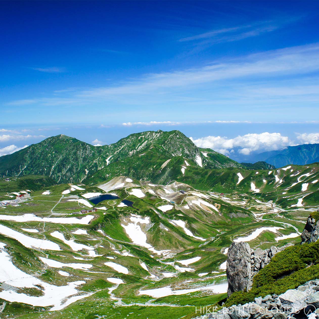
- Area: Kita Alps (北アルプス)
- Height: 3015m
- Yama to Kogen Map: No.37 剱・立山 Tsurugi/Tateyama
Worshipped since ancient times, Tateyama is one of Japan's three most sacred mountains (along with Mount Fuji and Mount Haku). Technically a mountain range, Tateyama is the collective name for three peaks: Oyama 雄山 (3003m), Onanjiyama 大汝山 (3015m), and Fujino Oritate 富士ノ折立 (2999m). The mountain range is one of the most easily accessible areas in the Northern Hida Mountains, with trails for varying levels. The Tateyama Kurobe Alpine Route to Murodo takes hikers to a starting point of 2,450m. As such, climbing Tateyama is popular with families and beginners alike.
百名山
Access
Train: Take the Toyama Chiho Railway to Tateyama Station. From there, take the Alpine Route to Murodō (accessible upstairs from the train platforms). It is also possible to hike from Tateyama Station.
Car: Head to Tateyama Station (Toyama Chihō Railway 富山地方鉄道). There is a free carpark down the road from the station.
- Intermediate 中級
Oyama Route
- Time: 4h 50
- Distance: 6.8km
- Elevation Change: 762m
Murodo Terminal (室堂ターミナル) ~ (10m) ~ Tateyama Murodo Sansou (立山室堂山荘) ~ (1h) ~ Ichinokoshi (一ノ越) ~ (1h) ~ Oyama (雄山) ~ (45m) ~ Ichinokoshi (一ノ越) ~ (1h 5m) ~ Tenboudai (展望台) ~ (40m) ~ Tateyama Murodo Sansou (立山室堂山荘) ~ (10m) ~ Murodo Terminal (室堂ターミナル)
Murodo Loop Route
- Time: 7h 30m
- Accumulated Elevation Change: 1285m
This course takes you around the Tateyama Mountain Range. While a fast experienced hiker could easily complete this in a day, we recommend staying at one of the mountain huts or hotels.
Murodo Terminal (室堂ターミナル) ~ (10m) ~ Tateyama Murodo Sansou (立山室堂山荘) ~ (1h) ~ Ichinokoshi (一ノ越) ~ (1h) ~ Oyama (雄山) ~ (20m) ~ Oonanjiyama (大汝山) ~ (15m) ~ Fuji no Oritate (富士ノ折立) ~ (25m) ~ Ojiri Junction (大走り分岐) ~ (10m) ~ Masago Dake (真砂岳) ~ (1h) ~ Bessan Nanpo (別山南峰) ~ (30m) ~ Bessan Nokkoshi (別山乗越) ~ (1h 30m) ~ Raicho Sawa Campsite (雷鳥沢キャンプ場) ~ (15m) ~ Reicho Dai (雷鳥台) ~ (20m) ~ Mikurigaike Onsen(みくりが池温泉) ~ (25m) ~ Tateyama Murodo Sansou (立山室堂山荘) ~ (10m) ~ Murodo Terminal (室堂ターミナル)
Lodges and Hotels
Hotel Tateyama
If you are someone who needs creature comforts and don't mind spending a little extra, we recommend staying at Hotel Tateyama. Open April 15~November 29, you can experience Tateyama throughout the seasons.
Hotel Tateyama Official Website (English)Ichino-koshi Sanso
Popular Sanso 1 hour from Oyama peak.
Ichino-koshi Sanso Official Website (Japanese)Raichoso
Cozy lodge with onsen. It is possible to book online from their website.
Raichoso Official Website (Japanese)Raichozawa Hyutte
Large lodge with onsen.
Raichozawa Hyutte Official Website (Japanese)Onsen
Many of the lodges have onsen or baths.
Mikurigaike Onsen みくりが池温泉
You can get a day ticket for around ¥800. Those staying at the onsen overnight are able to use the baths any time thay wish.
Mikurigaike Official Website (English)Toilets
There are toilets at the stations and at various lodges along the route. You may be charged to use facilities at lodges.
近畿
Odaigahara 大台ヶ原山

- Area: Nara / Mie (奈良・三重)
- Height: 1695m
- Yama to Kogen Map: No.53 大台ヶ原山 Odaigahara
This relaxing hiking course features an open plain, moss-draped forest, and views as far as the sea. From the summit is a 360 panoramic view of the surrounding area and views as far as the sea. The course is especially popular in the autumn when the scenery turns to brilliant reds and oranges.
百名山
Access
- Train and Bus
From Kyoto or Osaka take a train to Kintetsu-Nara Station. Take the Kintetsuline to Yamato-Kamiichi Station. From there take the Nara Kotsu Bus to Odaigahara (aproximately 2h; ¥2050). There is only one bus each direction a day.
Nara Kotsu Bus Odaigarahara Timetable (English)Visit Nara Odaigahara Destination Guide (English)
- Car
Head to Odaigahara Visitor Centre Car Park. There are 200 park spaces available. Google Map link below.
Google Map Odaigahara Visitor Centre- Beginner 初級
A Course
- Time: 3h 20m
- Distance: 8km
- Elevation Change: 697m
大台ヶ原駐車場(40分)-日出ヶ岳(30分)-正木ヶ原(10分)-尾鷲辻(15分)-牛石ヶ原(25分)-大蛇グラ(30分)-牛石ヶ原(15分)-尾鷲辻(35分)-大台ヶ原駐車場
B Course
- Time: 3h 38m
- Distance: 7.5km
- Elevation Change: 833m
大台ヶ原駐車場(41分)-日出ヶ岳(30分)-正木ヶ原(10分)-尾鷲辻(15分)ー牛石ヶ原(25分)-大蛇グラ(58分)-シオカラ谷吊橋(40分)-大台ヶ原駐車場
C Course
- Time: 5h 11m
- Distance: 9.4km
- Elevation Change: 717m
大台ヶ原駐車場(76分)-七ツ池(60分)-開拓分岐点(25分)-展望台(25分)-逆峠(25分)-開拓分岐点(40分)-1398m地点(45分)-大台ヶ原駐車場
Kamikitayama Odaigarara Course Page (website uses google translate)Toilets
There are toilets in the carpark and visitor centre at the start of the trail.
Hakusan 白山

- Area: Ishikawa/Gifu (石川・岐阜)
- Height: 2702m
- Yama to Kogen Map: No.44 白山 Hakusan
Along with Mount Fuji and Tateyama, Hakusan is revered as one of Japan's three most sacred mountains. According to legend, Buddhist priest and key religious figure in mountain worship, Taicho Daishi, climbed the mountain in 717 (Nara Period) and was visited there by a Goddess. Not only does the mountain hold significant meaning to the Shugendo religion, it is also famous for its otherworldly natural beauty. Hakusan and its surrounding National Park were designated a UNESCO Biosphere Reserve in 1980.
百名山
Access
During peak hiking season (July ~ October) there are restrictions on road access.
Car (July ~ October): Park in the Ichinose parking lot (700 spaces, free) and take the shuttle bus (charged) to Betto-deai (別当出合), where the trailhead is.
Car (non-peak seasons): Go to Betto-deai parking lot through Ichinose (200 spaces, free).
Train and Bus (July ~ October): Head to JR Matto Station (松任駅 まっとうえき). From there, take the Hakusan Tozan Bus (around 2h) to Betto-deai (別当出合).
Another option is to take the shuttle bus from Kanazawa station (金沢駅).
Hakusan Bus Information (Japanese)- Intermediate 中級
Saboshindo Route
- Time: 8h 50m
- Distance: 13.1km
- Elevation Change: 1442m
The Saboshindo Route is a well signposted route that will take you to Murodo and then up to the peak. There are toilets at 4 points on the route up to the peak.
Day 1
- Time: 4h
Day 1 takes you up to the Hakusan Murodo lodge.
Betto-deai (別当出会) ~ (50m) ~ Nakahanba ~(1h 30m)~ Jinnosuke Shelter Hut ~(1h 10)~ Kurobokoiwa (黒ボコ岩) ~(30m)~ Murodo (室堂)
Day 2
- Time: 4h 50m
Day 2 takes you up to the peak and back down. Many hikers like to wake up 1 hour before sunrise to hike the 40 minutes to the summit with their headlamps. Most people take a day pack to hike around the summit, then collect the rest of their belongings on the way back down.
Murodo (室堂) ~(40m)~ Gozengamine (御前峰) ~ (30m)~ Senjyagaike Bunki (千蛇ヶ池分岐) ~ (40m) ~ Murodo (室堂) ~(20m)~ Kurobokoiwa (黒ボコ岩) > Kankoshindo Route (観光新道) ~ (50m)~ Tonodaike Shelter Hut ~ (50m)~ Bettozaka Bunki / Keimatsudaira (別当坂分岐) ~ (1h) ~ Betto-deai (別当出会)
Hakusan Map PDF from Hakusan Tourist Association (English)
Lodges
Hakusan Murodo: Hakusan Murodo is run by the ciy government and has enough space for up to 750 people. There are flushing toilets!
Fun fact! There is a post office at Murodo. Hikers often send postcards from the mountain top.
Hakusan Murodo Official Page (English)Hakusan Raichoso: Hakusan Raichoso is a fairly new facility built in 2012. The facility consists of private rooms for groups of 3 to 4 people. Not that if you book one of these rooms you will be expected to pay a deposit via bank transfer.
Hakusan Raichoso Official Page (English)Naryusanso 南竜山荘: Naryu Sanso also has a campsite.
Naryusanso Official Website (Japanese)Helpful Resources
Official Hakusan Hiking Website (English)
Hakusan National Park Pamphlet PDF From Hakusan Tourist Association (English)
中国・四国・九州 Chukoku / Shikoku / Kyushu
Tsurugi San 剣山
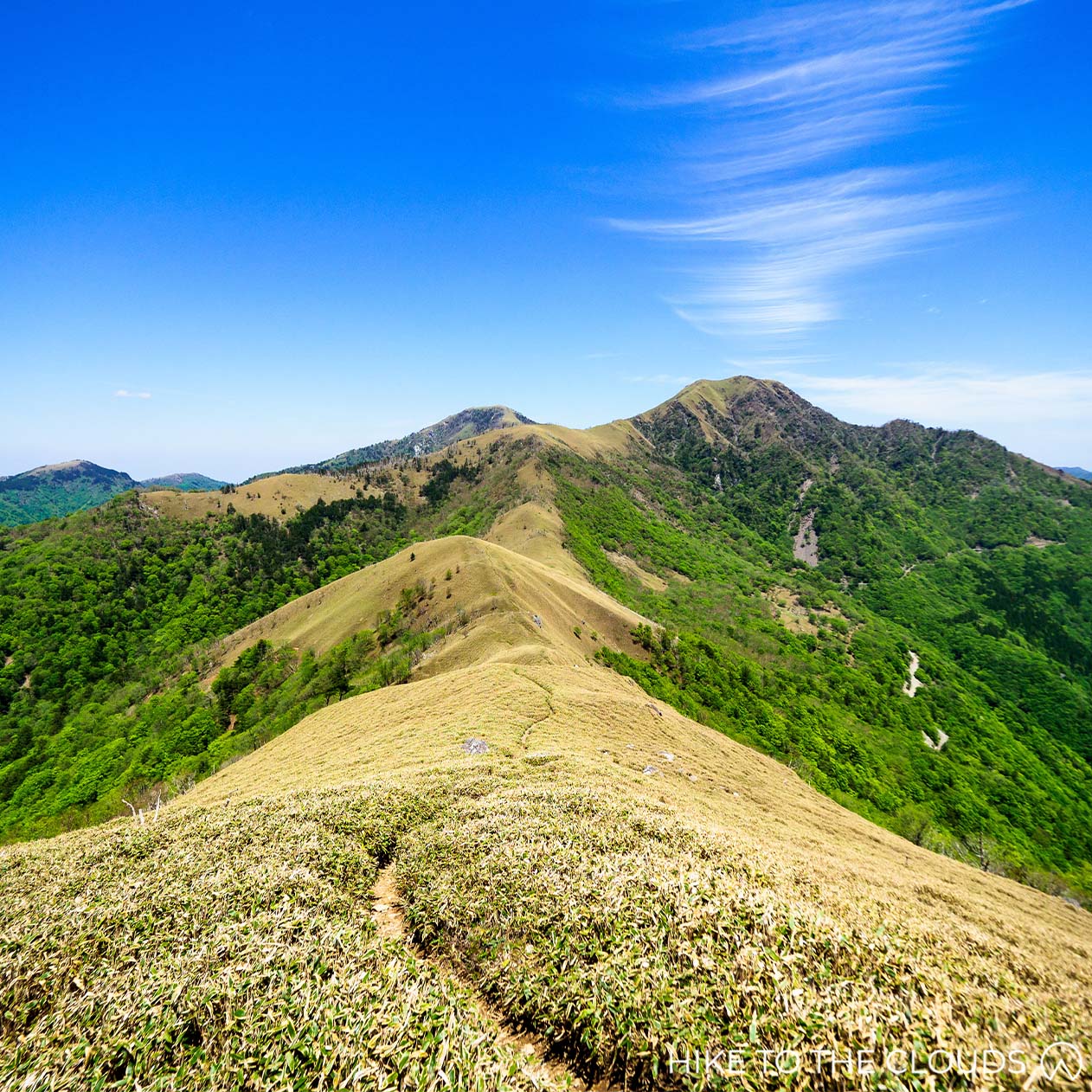
- Area: Tokushima (徳島県)
- Height: 611m
- Yama to Kogen Map: No.56 石鎚・四国剣山 Ishizuchi/Shikoku Tsurugi-san
A relaxing ridge hike in one of the most beautiful areas of Japan. Mount Tsurugi (not to be confused with Tsurugi-dake), is the highest peak in Tokushima, and the second highest in the whole of Shikoku. Despite it's height, it has some nice beginner trails. Mount Tsurugi is one of Japan's spiritual mountains, worshipped in Shugendo. As such there are several shrines on the mountain.
百名山
Access
- Train and Bus
Take a train to Sadamitsu Station JR貞光駅. From their take the Tsurugi Bus つるぎ町営バス to Minokoshi 見ノ越.
Community Bus Website (Japanese)Tsurugi Hiking Bus Schedule PDF
- Car
Minokoshi Carpark (見ノ越駐車場) is a free carpark near to the chair lift station.
- Beginner 初級
Beginner Course
- Time: 2h 5m
- Distance: 3.21km
Nishijima Top Chair Lift Station 西島 ~(90分)~ Mount Tsurugi 剣山 ~(5分)~ Tsurugi Summit Hutte 剣山頂上ヒュッテ ~ (20分)~ Katanakake 刀掛 ~(10分)~ Nishijima 西島
Without using the chair lift
- Time: 2h 45m
- Distance: 6km
- Elevation Change: 611m
Minokoshi Carpark 見ノ越駐車場 ~(50分) ~ Nishijima 西島 ~(20分)~ Otsurugi Shrine 大鶴城神社 ~(15分)~ Tsurugi Summit Hutte 剣山山頂ヒュッテ ~(5分)~ Mount Tsurugi 剣山 ~ (5分)~ Tsurugi Summit Hutte 剣山山頂ヒュッテ ~(10分)~ Otsurugi Shrine大剣神社(15分)~ Nishijima 西島(45分)~ Minokoshi Carpark 見ノ越駐車場
Tsurugi Lift Information (Japanese) Tsurugi San official website (Japanese)Lodges・Campsites
Tsurugi-San Summit Hutte (剣山頂上ヒュッテ): Tsurugisan Hutte is just below the summit. It is a fantastic place to stay if you are hoping to watch the sunrise on the mountain.
Ichi no Mori Hutte (一ノ森ヒュッテ) Ichinomori is 50m further along the ridge from Mount Tsurugi.
Camping
It is possible to camp near Otsurugi Shrine or at Ichinomori Hutte. Ichinomori is a 50m hike from Tsurugi-san Summit Hutte.
Tsurugisan Summit Hutte WebsiteIchinomura Hutte information (Japanese)
Mount Kuju 九重山

- Area: Kyushu
- Height: 1791m
- Yama to Kogen Map: No.58 Aso / Kuju (阿蘇・九重 由布岳)
Mount Kuju is one of two active volcanoes in the Aso-Kuju National Park. Hikers and tourists come from all over to experience the famous onsen resorts and incredible nature.
百名山
Makinoto Pass can be reached by train and bus, or by car.
By Train and bus: Take a train to Bungonakamura station (豊後中村駅). There is a bus from the train station to the trail head from Spring to Autumn. Take the Kuju Machi Community Bus (九重町コミュニティバス) to the Makinoto Pass Trailhead (牧ノと峠). It takes around 1 hour.
By car: There is a free carpark that holds roughly 150 cars.
Map of trailheads and facilities provided by Chojabaru Visitor Canter
- Beginner 初級
Due to its central location within the Kuju massif and the extensive network of hiking trails, Mount can be reached from several trails.
Makinoto Pass to Chojabaru
- Time: 4h 30m
- Distance: 10.5km
- Elevation Change Up: 645m
- Elevation Change Down: 942m
Makinoto Pass (牧ノと峠) ~ (30m) ~ Kutsukake Yama (沓掛山) ~ (1h) ~ Ogigahana Bunki (扇ヶ花分岐) ~ (30m) ~ Kuju Wakare (久住分かれ) ~ (25m) ~ Mount Kuju (久住山・九重山) ~ (15m) ~ Kuju Wakare (久住分かれ) ~ (35m) ~ Kitasenrihama (北千里浜) ~ (5m) ~ Sugamori Goe (スガモリ越) ~ (1h 10m) ~ Chojibaru (長者原)
Makinoto Pass to Mount Kuju (there and back)
- Time: 4h 10m
- Elevation Change: 645m
Makinoto Pass (牧ノと峠) ~ (30m) ~ Kutsukake Yama (沓掛山) ~ (1h) ~ Ogigahana Bunki (扇ヶ花分岐) ~ (30m) ~ Kuju Wakare (久住分かれ) ~ (25m) ~ Mount Kuju (久住山・九重山) ~ (15m) ~ Kuju Wakare (久住分かれ) ~ (30m) ~ Ogigahana Bunki (扇ヶ花分岐) ~ (40m) ~ Kutsukake Yama (沓掛山) ~ (20m) ~ Makinoto Pass (牧ノと峠)
These routes take you through stunning natural beauty, but don't be caught off gaurd, this area is home to 2 active volcanoes. Keep an eye out for restricted areas.
Mount Naka-dake CourseKuju Area Maps
Onsen / Huts / Visitor Centre / Toilets
- Toilets
There are toilets in Makinoto Pass Carpark, Kuju Hut (a small escape hut just before Kuju Wakare), and Chojabaru Carpark.
Kuju Area Facilities Guide- Chojabaru Visitor Center
Chojabaru Visitor Center Tel: 0973-79-2154
Visitor Center Official Website (English)Mount Aso 阿蘇山

- Area: Kyushu (九州)
- Height: 1592m
- Yama to Kogen Map: No.58 Aso / Kuju Yufu-Dake 阿蘇・九重 由布岳
Located in Kumamoto Prefecture in the central Kyushu region, the humongous volcano is phenomenal. The five peaks that form the core of the volcano and lie in an almost perfect line east to west are called the Aso Gogaku (five peaks of Aso): Neko-dake, Taka-dake (the highest peak), Naka-dake (the most active crater), Eboshi-dake and Kishima-dake. The mountain massif is divided into two main sections: the west side (Kishima and Eboshi) and the east side (Neko, Taka and Naka). The gentle trails around the grasslands on the western side of the massive are perfect for beginner hikers. Tengu Iwa in the central zone is a rocky alpine climbing territory. The mountain is easily accessible, and hiking can be enjoyed all year round. Mount Aso is one of Japan's most active volcanoes. As the restriction levels often change, please check updates on the trails before hiking.
百名山
Access
- By Car
Head to Kusasenri Parking Lot (草千里駐車場). The carpark has 300 spaces and costs ¥500.
Google Maps- Public Transport
From Kumamoto Airport, take a Kuko Renraku (airport shuttle) “Yamabiko” bus to Aso Station (about 1h 30m). From Aso Station, take a Kyushu Kotsu Bus Lines Aso Kako Line bus to the Kusasenri Aso Volcano Museum Bus Stop (30m).
Mount Aso is an active volcano with ongoing activity. The Japan Meteorological Agency issues the latest eruption warnings and forecasts, so please check them before deciding whether to hike. There are also restrictions due to volcanic gases, so check local information on your route as well.
Check out latest restrictions here (English)Japan Meteorological Agency Website (Japanese)
Mount Eboshi Route
- Beginner 初級
- Time: 2h 20m
- Distance: 4km
- Elevation Change: 242m
This beginner route takes you through the grasslands and up to a summit overlooking the area.
Aso Volcano Museum (火山博物館前) ~ (1h 20m) ~ Ridgeline / Ryosen (稜線) ~ (20m) ~ Mount Eboshi (烏帽子岳) ~ (30m) ~ Aso Volcano Museum (火山博物館前)
Mount Kishima Route
- Beginner 初級
- Time: 1h 40m
- Distance: 4.3km
- Elevation Change: 507m
This route is completely paved and can be tagged onto the route above for a longer hike.
Aso Volcano Museum (火山博物館前) ~ (20m) ~ Mount Kishima Bunki (杵島岳分岐) ~ (20m) ~ Mount Kishima (杵島岳) ~ (20m) ~ Kishima-Dake Trailhead (towards the ski-ground) (スキー場方面杵島岳登山口) ~ (15m) ~ Aso Volcano Museum (火山博物館前)
NB "分岐" (bunki) is a split or junction in the trail
See the Eboshi-Dake 烏帽子岳 and Kishima-Dake 杵島岳 trails on the left hand side of this map.
Kishima-Dake Trails PDF from Kumamoto Prefecture
Naka-Dake New Route (皿山ルート)
- Intermediate 中級
We don't know a lot about this new route yet. See the map below to see the new route around the restricted trails.
Map PDFYama Ue Hiroba (山上広場) ~ Shin Tozan Do / New Hiking Route 新登山道 ~ 中岳 ~ Shin Tozan Do / New Hiking Route 新登山道 ~ Yama Ue Hiroba (山上広場)
As of 2019, volcanic activity, including eruptions, has caused both Naka-dake and Taka-dake to be declared restricted to hikers. In April 2022, the activity level was dropped from level 2 to level 1. Despite this, there is still a 1 km no go zone around the crators. Therefore THE ROUTES BELOW ARE CURRENTLY OFF-LIMITS. According to information on the Mount Aso website, trails are being prepared to be re-opened. We have left our guides up here for your information and in hope that they will be opened again at some point in the near future.
Map PDF showing where trails are restricted.Neko-Dake Ridge Route 根子岳 大戸尾根ルート
- Intermediate 中級
- Time: 2h 40m
- Distance: 4.3km
- Elevation Change: 810m
Mount Neko Emergency Hut Carpark (根子岳地獄谷避難小屋前駐車場) ~ (1h 30m) ~ Tohou (東峰) ~ (1h 10m) ~ Mount Neko Emergency Hut Carpark (根子岳地獄谷避難小屋前駐車場)
Eastern Side 中岳・高岳 Route
- Intermediate 中級
- Time: 4h 25m
- Distance: 7.5km
- Elevation Change: 554m
Nakadake is the most active crater in the massif.
As this route passes near the crater, the risk of exposure to volcanic gases (sulphur dioxide) is high. These toxic gases can be deadly, so please think carefully and prepare accordingly before ascending the mountain. If you notice a strong odour, cover your mouth and nose with a wet towel and descend the volcano immediately.
Kakou Nishi Eki / Kakou West Station (阿蘇山西駅) ~ Sunasenrigahama (砂千里ヶ浜) ~ (1h 30m) ~ Naka-dake (中岳) ~ (40m) ~ Taka-dake (高岳) ~ (20m) ~ Taka-dake Nishi ~ (45m) ~ Taka-dake (高岳) ~ (30m) ~ Naka-dake (中岳) ~ Sunasenrigahama (砂千里ヶ浜) ~ (1h) ~ Kakou Nishi Eki / Kakou West Station (阿蘇山西駅)
- Toilets
There are toilets available in the main carpark and at the visitor center.
- Visiter Center
The Visitor Center is located in Kusasenri, the access base for climbing Mt Aso. The base area has a museum, cafes and toilets. Pop into the Visitor Center for maps and the latest information on the volcano activity.
Mount Aso Visitor Center Tel: 0967-34-2111
Visitor Center Official Website (Japanese)Google Maps
- Aso Volcano Museum
- Hot Springs
Dondoko Onsen Website (Japanese)
Kurokawa Onsen (English)
Kirishimayama 霧島山
- Area: Kagoshima / Miyazaki (鹿児島・宮崎県)
- Height: 1700m
- Yama to Kogen Map: No.60 霧島・開聞岳 市房山 Kirishima / Kaimondake
Mount Kirishima (Kirishima Yama) is the name for 20 volcanoes stretching out over 20km east to west between Miyazaki and Kagoshima prefectures. The tallest mountain (and therefore technically the Top 100 Mountain) is Mount Karakuni, but other volcanoes in the range are equally famous. The striking Shinmoedake was used as the villain's base in the classic Bond movie You Only Live Twice (1967), and Mount Takachiho is celebrated as the place where the God Ninigi no Mikoto came down to earth and started the Imperial Family. The name Kiri 霧 (mist) comes from the fact that the mountains often appear to be veiled in mist, adding to their mysterious and divine aspect. The full name Kirishima conjures the image of an island shrouded in mist.
百名山
Access
- Train and Taxi / Bus
Take a train to Kirishima Jingu Station (霧島神宮駅). From there take a taxi to Ebino Kogen.
Take a train to Kirishima Jingu Station (霧島神宮駅). From there it is possible to take a bus to Maruo. At Maruo change to a bus headed to Ebino Kogen / Ebino Platou (えびの高原). There are very few buses each day, check out the timetables HERE. The website is machine translated so where it says "Korea Mountain", it means "Mount Karakuni".
- By Car
Go to the Ebina Eco Museum Center (えびのエコミュージアムセンター駐車場).
The center acts as the Kirishima Visitor Center and has a free carpark.
Ebina Eco Museum Center - Access Page (English)
As of 28th March 2022 - Eruption Alert Level 2.
Volcanic earthquakes with epicentres directly under the crater are increasing. As there is a risk that an eruption may occur in the future, the eruption alert level has been raised from level 1 to level 2 (restrictions around the crater). For more information on the detailed precautions, please see the Ebino Eco Museum Center Website below.
Mount Karakuni (From Ebino)
- Intermediate 中級
- Time: 4h 46m
- Distance: 9.3㎞
- Elevation Change: 718m
Ebino Carpark (えびの駐車場) ~ (2h) ~ Ebino Kogen (えびの高原) ~ (20m) ~ Mount Karakuni Trail Head (韓国岳登山口) ~ (40m) ~ 5th Station (五合目) ~ (40m) ~ Mount Karakuni (韓国岳) ~ (50m) ~ Emergency Hut (避難小屋) ~ (50m) ~ Onami Ike (大浪池休憩所) ~ (1h 24m) ~ Ebino (えびの)
Kirishima Kokusai Hotel has some maps of various courses around the area. The second map shows the route above.
Kirishima Kokusai Hotel - Trekking Page with Maps (Japanese)
Ebino Eco Museum Center - Daily Updates on Volcanic Activity and Weather conditions (English)
- Toilets
There are toilets at the Ebino Eco Museum Center.
- Camp Sites
Ebino Plateau Camp Village
The best base for hiking Mount Karakuni and it's surrounding area. The campsite has 14 cabins, wooden decks, and open tent sites.
Facilities invclude a cooking building, toilets, and central lodge. There is also an onsen available through the camping season.
The camp is closed between November 1 to December 19, January 11 to March 31 (Onsen: December 20 to January 10)
Tel: (+81) 0984-33-0800
Address: Suenaga 1470, Ebino City, Miyazaki Prefecture
Hinamori Auto Camping Ground
Email: hinamoni@m-forest-a.or.jp
Official Website (English Machine Translation)Miike Camp Village
9 cottages, 2 stilted bungalows, 30 pre-pitched tents
Cooking building, shower building, toilets
Two of the forest cabins are also wheelchair accessible.
Tel: (+81) 0984-42-4038
Reservation via Expedia (booking website)- Hot Springs
Kirishima Hot Spring Resort
Kirishima Hotel (English)Shirotori Onsen
Official Website (Japanese)Shinyu Onsen
Website (Japanese)Sakura Sakura
Official Website (English Machine Translation)- Bike Rental
Another fun outdoor activity to explore the area is biking. It has become so popular that they have made a website dedicated to it. Take a look at the routes and book your bike from the website below.
Bike Trip Kirishima (Official Website)- Other Useful Websites
Tourism Map (Japanese) - provided by Kirishima Tourism Association
Outdoor City Ebino - Official Website (English)
Takachiho Visitor Center (Japanese)
Kirishima Tourism Association - Official Website (Japanese)
Kaimondake 開聞岳

- Area: Kagoshima (鹿児島)
- Height: 924m
- Yama to Kogen Map: No.60 霧島・開聞岳 市房山 Kirishima / Kaimondake
Green mossy Kaimondake, on the Satsuma Peninsula of Kagoshima, is the second lowest of Japan's Top 100 mountains. Despite this, the elevation change is around 900m. Ladders and large rocks along the way make the mountain a little steep for beginners. There is only one route up to the peak, which takes hikers in a spiral pattern to the summit. From the top, it is possible to see Kirishima, Yakushima and sightseeing spots around the area. The mountain is also beautiful from a distance, and its striking pyramid shape has given it the nickname Satsuma-Fuji.
百名山
Access
Train: Take a train to Kaimon Station (開聞駅).
Car: Park at Kaimon Sanroku Fureai Park Car Park (かいもん山麓ふれあい公園駐車場). The car park is free and can hold up to 120 cars.
- Intermediate 中級
There is only 1 route up to the peak. The trail is well signposted and easy to follow.
From Kaimon Station
- Time: 5h 20m
- Distance: 11km
- Elevation Change: 917m
If you are starting at the Car Park (rather than the train station) then the elevation change is around 800m, and climbing time is around 4h.
Kaimon Train Station (開聞駅) ~ (40m) ~ Nigome Trailhead (二合目登山口) ~ (50m) ~ 5th Station (五合目) ~ (40m) ~ Sennindo (仙人洞) ~ (50m) ~ Kaimondake Summit (開聞岳)
Kaimondake Summit (開聞岳) ~ (40m) ~ Sennindo (仙人洞) ~ (30m) ~ 5th Station (五合目) ~ (40m) ~ Nigome Trailhead (二合目登山口) ~ (30m) ~ Kaimon Train Station (開聞駅)
Hiking Map PDF provided by Ibusuki TourismToilets
There are toilets at the train station and in the car park.
Ibusuki Tourism Website (automated English translation available)
東北 Tohoku
Hakkodasan 八甲田山

- Area: Aomori (青森)
- Height: 1585m
- Yama to Kogen Map: No.4 Hakkoda / Mount Iwaki (八甲田・岩木山 白神岳・十和田湖・田代岳)
Hakkoda is a group of 18 mountains in Aomori, the tallest of which is Hakkoda Odake. As well as being a top 100 mountain, North Hakkoda has been selected as one of the 100 Famous Mountains for flowers. The Hakkoda-Odake peak has 360-degree views over the entire area, including its other-worldly marshlands, gorges, and waterfalls. The ropeway makes the mountain accessible to everyone and a fantastic destination to visit as a family. The hiking season runs from June to late October. As Hakkoda is well known for its harsh winters with record snowfall, roads are closed to the area in Winter. However, every April, the closed winter road from the Sakagayu Hakkoda Hotel to Yaji Onsen is cleared of snow and opened as a 'snow corridor'. Snow walls up to 10 metres high are astonishing to behold!
百名山
Access
- Public Transport
Go to JR Shin-Aomori Station (Shinkansen), head to the Bus Terminal and take a JR Bus bound for Lake Towada (十和田湖). Get off at Hakkoda Ropeway Eki Mae. The ride takes around 55 minutes. During the winter months, ride the bus bound to Sukayu Onsen.
- By car
Hakkoda Ropeway car park (八甲田ロープウェイ駐車場) can hold up to 350 cars and is free to use.
There is also a free carpark at Sukayu Onsen Parking Lot (酸ヶ湯公共駐車場) with 100 spaces available.
- Intermediate 中級
Ropeway Course
- Time: 4h 25m
- Distance: 8.5km
- Elevation Change Up: 479m
- Elevation Change Down: 884m
Sancho Koen Station / top ropeway station (山頂公園駅) ~ (1h 20m) ~ Akakuradake (赤倉岳) ~ (1h) ~ Hakkoda~Odake (八甲田大岳山頂) ~ (55m) ~ Akakuradake (赤倉岳) ~ (1h) Sancho Koen Station (山頂公園駅)
Ropeway to Sukayu Onsen
- Time: 4h 30m
- Distance: 9km
Sancho Koen Station / top ropeway station (山頂公園駅) ~ (1h 20m) ~ Akakuradake (赤倉岳) ~ (1h) ~ Hakkoda~Odake (八甲田大岳山頂) ~ (25m) ~ Odakeanbu Emergency Hut (大岳鞍部避難小屋) ~ (50m) ~ Kamikenashitaitenboudai (上毛無岱隊展望台) ~ (50m) ~ Sukayu Onsen (酸ヶ湯温泉)
Sukayu Onsen Loop
- Time: 4h 35m
Sukayu Onsen (酸ヶ湯温泉) ~ (1h 20m) ~ Emergency Hut ~ (5m) ~ Kodake Bunki (小岳分岐) ~ (50m) ~ Hakkoda~Odake (八甲田大岳山頂) ~ (25m) ~ Odakeanbu Emergency Hut (大岳鞍部避難小屋) ~ (30m) ~ Miyasama Bunki (宮様分岐) ~ (40m) ~ Kenaishitai (毛無岱) ~ (30m) ~Jogakura Bunki (城ヶ倉分岐) ~ (20m) ~ Sukayu Onsen (酸ヶ湯温泉)
Hotels and Hot Springs / Toilet / Ropeway
Toilets
There are toilets at the cable car stations, at Mount Odake Hut, and in the carpark.
Hakkoda Ropeway
Hakkoda Ropeway Official Website (English)Onsen / Hot Springs
Sukayu Onsen (Japanese Website)English Online Booking
Hotel
Hakkoda Resort Hotel (Japanese Website)Hakkoda Resort Hotel (English Booking Site)
Campsite
There is a camp ground near Sukayu Onsen and carpark.
Camp Sukayu TripadvisorOfficial Camp Sukayu Website (Japanese)
Other Resources
Aomori Tourism Website (English)Hachimantai 八幡平
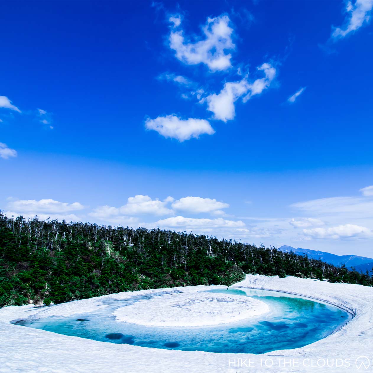
- Area: Iwate / Akita (岩手・秋田)
- Height: 1613m
- Yama to Kogen Map: No.5 Mount Iwate / Hachimantai (岩手山・八幡平 秋田駒ヶ岳・姫神山・森吉山・和賀岳)
Hachimantai is known for its gentle dome shape. The Japanese refer to it as "aspite" terrain, which apparently means that it resembles the shape of a shield. Imagine Captain America's shield on the ground, and you'll get the idea. Now, imagine that the shield is covered in luscious marshlands with small peaks peeping out. Add in fields of purple belled wildflowers (tachigiboushi), bright yellow daylilies, and glimmering ponds. If you started imagining fairies and willow-the-wisps, they wouldn't seem out of place. Being on Hachimantai feels like you have crossed over into a fairytale world. In fact, if you go in late spring, you may even see a Dragon Eye (see picture).
百名山
Access
Hachimantai can be easily reached by train and bus, or by car during peak season. The peak season is between May and early November.
- Public Transport
Head to Morioka Station. From there, hop on a bus bound for Hachimantai from stand 3 at the east exit of Morioka Station. Get off at Chausuguchi (茶臼口).
Buses run from mid-April until early November.
- By Car
Take the Hachimantai Aspite Line. There are several carparks at different trail heads, including Hachimantai Tenbo Carpark (八幡平頂上), Obuka Onsen (大深温泉), and Kuroyachi Carpark (黒谷地).
- Beginner 初級
The large platoue has several routes and trailheads, five carparks and just as many bus stops. One bus stop just 30 minutes from the summit. If you just want to bag the peak, it can be done in under 1 hour. However, we think that Hachimantai's sprawling landscape lends itself to long leasurely strolls.
茶臼口
- Time: 5h
- Distance: 12km
- Elevation Change Up: 516m
- Elevation Change Down: 766m
This longer route takes you right across the platoue, through the flower feilds and past the ponds, ending at Fukenoyu Onsen. We recommend getting a bus from Morioka Station to Chausu Trailhead.
Chausu Trailhead (茶臼口) ~ (50m) ~ Chausudake (茶臼岳) ~ (40m) ~ Kuroyachi Shitsugen (黒谷地湿原) ~ (50m) ~ Genta Forest (源太森) ~ (30m) ~ Hachimantai Peak (八幡平) ~ (30m) ~ Kusanoyu Bunki (草の湯分岐) ~ (1h 20m) ~ Naganuma (北千里浜) ~ (30m) ~ Fukenoyu (蒸ノ湯)
Peak Bagging Loop
- Time: 1h 35m
This course takes you in a loop up to the summit and around the ponds. There is a carpark next to the bus stop for those who prefer to come by car.
Hachimantai Summit Bus Stop (八幡平頂上バス停) ~ (30m) ~ Hachimatai Summit (八幡平) ~ (25m) ~ Genta Ware (源太分れ) ~ (40m) ~ Hachimantai Summit Bus Stop (八幡平頂上バス停)
Hachimantai Map PDFToilets / Emergency Huts
Toilets: There are toilets in the Summit Carpark, and at the Ryounsou Refuge (陵雲荘), and Chausu Sansou (茶臼山荘) emergency huts.
Ryounsou Refuge (陵雲荘), and Chausu Sansou (茶臼山荘)
Iwate Onsen Website - Trekking Page (Japanese)Gassan 月山

- Area: Yamagata
- Height: 1,984m
- Yama to Kogen Map: No.8 鳥海山・月山・羽黒山・湯殿山
Gasson, literally "Moon Mountain", is the tallest and most holy of Yamagata’s three sacred Dewa Mountains. While on the mountain, you may be hiking along with people on a pilgrimage of rebirth.
百名山
Access
By Car:There is a carpark close to Ubazawa bus stop (姥沢バス停). From the bus stop you will need to walk 15 minutes to the Lower Lift Station (リフト下駅) > Take the pair lift (月山ペアリフト) up to the top station. It takes about 13 minutes.
By Train and Bus: First take the Yamagata Shinkansen to Yamagata Station > Take either the 山交バス or the 庄内交通バス (高速バス) 40 minutes to Nishikawa Bus Stop (西川バスストップ) > From there take the 西川町営バス to Ubazawa (姥沢), From the bus stop you will need to walk 15 minutes to the Lower Lift Station (リフト下駅) > Take the pair lift (月山ペアリフト) up to the top station. It takes about 13 minutes.
- Beginner 初級
Car Park / Bus Stop (駐車場・バス停) ~ (15m) ~ Lift Ue Eki (リフト上駅) ~ (30m) ~ Ubagadake (姥ヶ岳) ~ (20m) ~ Kanauba (金姥) ~ (30m) ~ Ushikubi (牛首) ~ (1h) ~ Gassan (月山) ~ (50m) ~ Ushikubi (牛首) ~ (20m) ~ Ubasawa / Lift Ue Eki Bunki (姥沢小屋・リフト上駅分岐) ~ (30m) ~ Lift Ue Eki (リフト上駅)
From the top lift station, take the path left up towards Ubagadake (姥が岳). In Spring and Summertime, the summit is covered in an abundance of flowers. Follow the wooden walkways along to Kanauba (金姥). Right up until the beginning of Summer, there are large patches of snow along the route (as in the photo), so be careful not to slip! Keep following the path towards the right to reach Ushikubi (牛首). From here, you will leave the wooden path onto a rocky trail. The following section is a little bit steep, but you’ll soon find yourself at a hut where you can take a break if you need to. From there, you will take a paved path up to the summit. After spending time at the peak and maybe visiting the shrine (¥500), head back the way you came. At Ushikubi (牛首), this time take a left towards Ubazawa Goya (姥沢小屋), after about 20 minutes you will reach a branch in the road. Don’t take the path towards Ubasawa Goya and the Lower Station (リフト下駅), unless you want to walk all the way down the mountain (It takes about 1h 20mins if you do want the challenge). Instead, head right towards the top station (リフト上駅), which will take around 30 minutes. Well done, and congratulations on completing another Top 100 Mountain!
Shrine
If you hope to visit the main shrine, visitors need to participate in the chief priest’s purification service before entering the main shrine building. The ceremony costs ¥500. Photography of Gassan Shrine is forbidden.
Mount Zaō 蔵王山

- Area: Yamagata / Miyagi
- Height: 1841m
- Yama to Kogen Map: No.7 Zaō 蔵王
Famous for its 5 coloured crator lake and winter snow monstors, Zao is a group of stratovolcanoes on the edge of Yamagata and Miyagi prefectures. An area of fascinating beauty, hikers from all over Japan head there between May and mid-October.
Read more about the 5 easiest top 100 百名山 mountains here百名山
Access
By Train: Take a shinkansen to Yamagata Station. Then take the bus route below.
By Bus: JR Shinkansen Yamagata Station, board a bus 山交バス (around 35m) to Zao Onsen Bus Terminal, from there walk about 15 minutes to Zao San 蔵王山魔駅, take the Zao Ropeway, change at the first ropeway station and take the Zao ropeway sancho line (蔵王ロープウェイ山頂線) to the top.
By Bus: (Longer hike from the other side)About 100 minutes by bus. From bus platform 1 in front of Yamagata Station (山形駅前1番), board bus bound for Zao Onsen・Togatta Sancho (蔵王温泉・遠刈田山頂). Alight at Zao Togatta Sancho (遠刈田山頂), the final stop. There is only one bus a day in each direction, so please be mindful of the schedule.
By Car: Yamagata Zao IC ~ 国道286号 ~ 県道 167, 53, 21, 14号
There is a free carpark
Zao Ropeway (English Website)
- Beginner 初級
Jizo Sancho Ropeway Station (地蔵山頂駅) ~ (25m) ~ Wasa hut (ワサ小屋跡) ~ (20m) ~ kumanodake (熊野岳) ~ (20m) ~ Uma No Se (馬の背) ~ (40m) ~ Wasa hut (ワサ小屋跡) ~ (40m) ~ Irohanuma (いろは沼) ~ (20m) ~ Juhyo kogen Ropeway Station (樹氷高原駅)
Toilets / Ropeway
Toilets: There are toilets in the carpark and ropeway stations.
Visit Miyagi (English Website)Zao Ropeway (English Website)
Adatarayama 安達太良山

- Area: Fukushima
- Height: 1700m
- Yama to Kogen Map: No.11 Bandai / Azuma (磐梯・吾妻 安達太良)
Mount Adatara in Fukushima is a stratovolcano. The gorgeous mountain has enchanted famous poets throughout history and is depicted in the Man'yoshu (the oldest anthology of Japanese poetry). As well as being a Japan top 100 mountain, it is also garnered a place in the top 100 mountains for flowers. The most popular time to visit Mount Adatara is at the beginning of Summer when azaleas are in bloom. We love to head over in Autumn when the foliage has changed into a sea of reds and oranges.
百名山
Read more about Adatara here
Adatarayama can be reached by train and bus, or by car.
During the autumn, there are a number of daily shuttle buses between Dake Onsen town and the rope-way. There is also often a shuttle bus service leaving from Nihonmatsu Station, which takes 50 mins.
By Train and bus: The nearest train station is Nihonmatsu Station. From JR Nihonmatsu Station, take the 福島交通バス to 岳温泉 (around 30mins), take a taxi (10 mins / around ¥2500), or take the Adatara express (10 mins) to the Sancho Station 山頂駅. It is possible to get a taxi and ropeway set ticket.
By car: Adatara Kogen Carpark (あだたら高原駐車場) is free and can hold up to 1500 cars. Nihonmatsu IC 二本松I.C > National Road 国道459 > Prefectural Road 県道386号
- Beginner 初級
For hikers who want more of a challenge, it is possible to hike from Okudake to Sancho Station instead of using the gondola. It would add roughly one and a half hours to your hike, making this a 5-hour hike (not including breaks).
Ropeway Route
- Time: 3h 25m
- Elevation Change Up: 365m
- Elevation Change Down: 771m
Sancho Station (山頂駅) ~ (35m) ~ Sennyotairabunki (善女平分岐) ~ (35m) ~ Mount Adatara (安達太良山) ~ (15m) ~ Tetsu zan・Mine no Tsujibunki (鉄山・峰ノ辻分岐) ~ (10m) ~ Mine no Tsuji (峰の辻) ~ (25m) ~ Kuroganegoya (くろがね小屋) ~ (25m) ~ Seishidaira (勢至平) ~ (1h) ~ Okudake (奥岳)
Takamura "Real Sky" (ほんとの空) stone monument. From there follow signs to Sennyotairabunki (仙女平分岐). After Sennyotairabunki, it will start to get a bit steeper, but you only need to climb 223 meters to the summit. Most people will be able to hike up in around 35 minutes. Once at the top, you will have 360 views of the surrounding area. Be careful taking photos as it can be pretty windy at the top. From here, it is all downhill. Continue onto Tetsu Zan (鉄山) and then down right at Mine no Tsujibunki (峰ノ辻分岐). Once you reach the crossroads at Mine no Tsuji, follow the signs to Kurogane Hut* (くろがね小や). There are toilets and an onsen here. From the hut, take a left and then right down to Seishidaira (勢至平). In the early Summer, the area is covered with red azaleas. From here, keep going down for about 1 hour until you reach Okudake (奥岳) and the bottom Adatara Express Station.
*If you want to take a shorter up and back route - once you reach the crossroads at Mine no Tsuji, there is a path back to Adatara Summit, and from there, you can retrace your steps back to the ropeway.
Ropeway / Toilets / Restaurants / Onsen
Toilets: There are toilets at the ropeway stations.
Helpful Resources
Ropeway Official Website (Japanese)Fukushima Tourism Website (Japanese, automated English translation available)
Restaurants and Onsen in the area (Japanese)
Adatara Kougen Resort Pamphlet PDF with Map (Japanese)
Mount Azuma 吾妻山

- Area: Fukushima (福島県)
- Height: 2035m
- Yama to Kogen Map: No.11 Bandai / Azuma (磐梯・吾妻 安達太良)
Mount Azuma is an active volcano with panoramic views over Fukushima City. It's also known as Mount Azuma-Kofuji, literally Little Fuji Azuma, which looks like a miniature Mount Fuji. Autumn is the most popular time to hike Azuma, but trails are open between April and November. If you have a few days and a car, we recommend camping near the Bandai-Asahi National Park lakes and hiking Mount Bandai and Adatarayama too.
百名山
Access
- Train and Bus
Prior to the pandemic buses ran from Fukushima Station and Yonezawa Station to the ropeway. However they are currently out of service (2022). For the time being, it is only possible to reach Azuma by car.
- By Car
The carpark at the Jododaira Visitors Centre costs ¥500 for the day.
Usagidaira Car Park is a free carpark 1km away from the Visitor Center and Azuma-Kofuji trail head.
- Beginner 初級
- Time: 3h 25m
- Hike up: 379m
The easiest route for beginners, which can be cut shorter if necessary.
Hokuboudai (北望台) ~ (20m) ~ Kamoshika Tenboudai (かもしか展望台) ~ (20m) ~ Okubo (大凹) ~ (40m) ~ Bonten Iwa (梵天岩) ~ (20m) ~ Mount Nishazuma (西吾妻山) ~ (10m) ~ Nishiazuma Hut (西吾妻小屋) ~ (10m) ~ Bouten Iwa (梵天岩) ~ (30m) ~ Okubo (大凹) ~ (25m) ~ Ningyo Ishi (人形石) ~ (30m) ~ Hokuboudai (北望台)
Take the ropeway and then three lifts to arrive at our 1820m starting point, Hokuboudai. You will see the beginning of the trail on your right once you arrive at Kamoshika Tenboudai (かもしか展望台). Please stay on the wooden path but be careful as it can get slippy in rainy weather. Take a right towards Okubo (大凹) (You will take the other trail to Ningyo Ishi (人形石) later on your return route). Keep following the wooden path up to Bonten Iwa (梵天岩). Take the left route up to Mount Nishiazuma summit. Well done! You have just bagged yourself another top 100 summit! Sadly the peak is surrounded by trees, so there isn't much of a view. From the summit, head around to Nishiazuma Hut, where toilets are available if needed. From here, make sure to take the right path towards Nishiazuma Shrine (西吾妻神社) and back to Bouten Iwa. Follow the path back the same way you came until your reach the branch. This time take the route to Ningyo Ishi (人形石), literally "Doll Rock", then follow the path left along a slightly rough trail back to the lifts.
Toilets
There are toilets at the ropeway stations.
Campsites
The Jododaira Campsite is the closest to the trailhead and managed by the Jododaira Visitor Center. According to the website, the price is ¥1000 for the site + ¥600 for each person (¥400 for children in elementary school or younger).
The campsite is open between May and October (exact dates vary by year).
Jododaira Campsite Website (Japanese)Helpful Websites
Fukushima Tourist Information (English)
Joudodaira Bandai-Asahi National Park (English)
Joudodaira Visitor Center Website (Japanese)
Mount Bandai 磐梯山
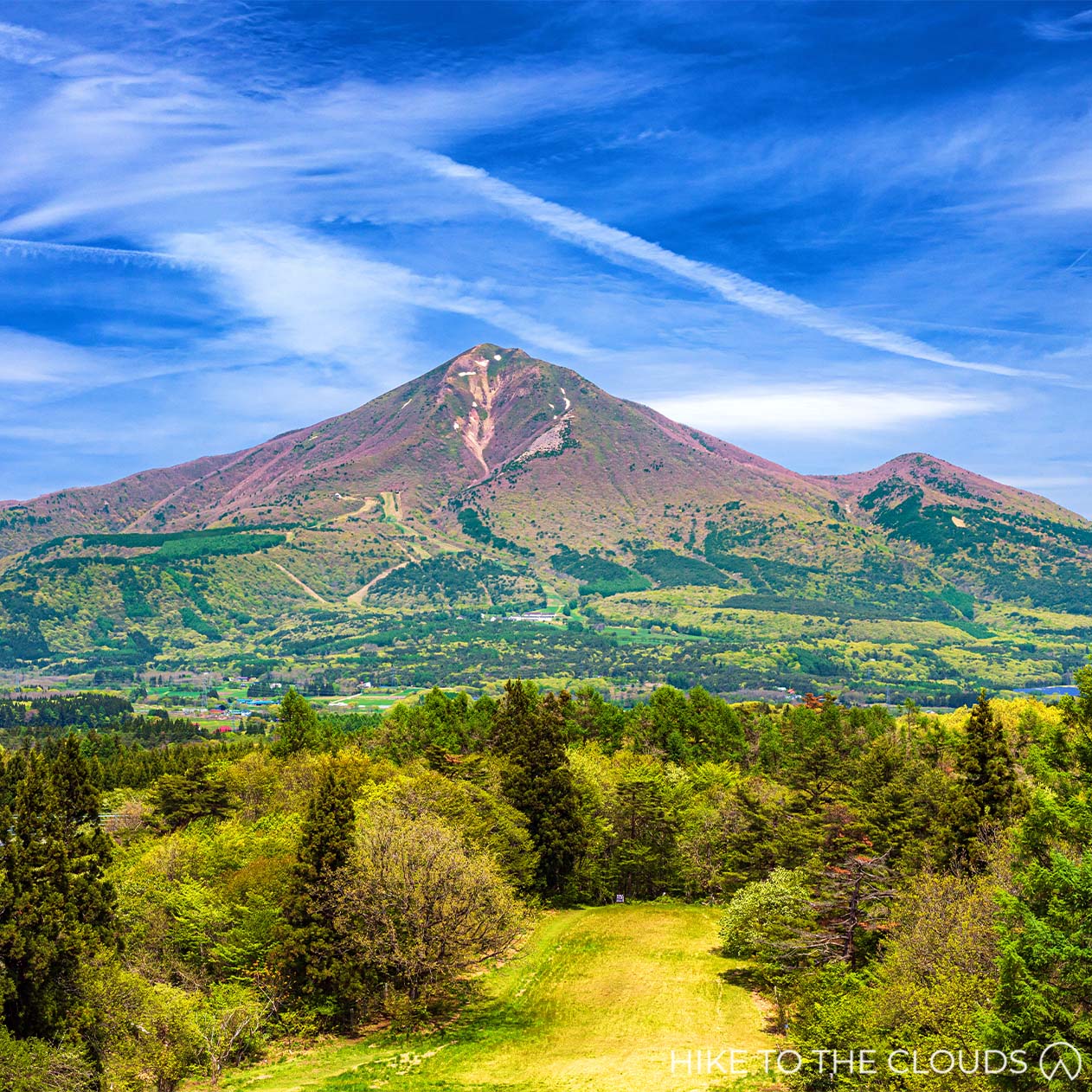
- Area: Fukushima
- Height: 1816m
- Yama to Kogen Map: No.11 Bandai / Azuma (磐梯・吾妻 安達太良)
Part of the Japanese Geopark Network, Mount Bandai is overflowing with beauty. There are several hiking trails. Strong-Beginners can take the 2-hour hike up Happodai trail to the summit, from where you can see 360° panoramic views of the Adatara, Iide and Azuma mountain ranges, with Lake Inawashiro glistening azure below. Bandaisan is an active volcano, so be sure to check warnings before your hike.
百名山
A car is necessary to get to Mount Bandai.
By train and taxi: It is possible to get a taxi from JR Bandaimachi Station to the Happodai trailhead. It takes around 25 minutes and costs roughly ¥6000 one way (this may have changed). Remember to book your taxi back because there is no mobile phone signal near or on the mountain.
Alternatively, there are rental car branches in Aizu-Wakamatsu, Koriyama and Fukushima City.
By car: There is a free carpark that holds roughly 150 cars. Take the Bandaisan Gold Line Happodai Trailhead (八方台登山口). There is a second carpark with the capacity for around 120 cars about a 5 minute walk from the trailhead. The Bandaisan Gold Line used to be a paid sightseeing toll road but has been made free to promote tourism.
- Intermediate 中級
Happodai Trail
The Happodai Trail is easy to follow and not technically difficult. However, while the trail is short, cimbing 700m in 2 hours can be quite strenuous for beginner hikers. Plan plenty of extra time for breaks. There are several points on the trail where you can stop and take in the views.
Also, bear in mind that the trail is quite narrow and gets narrower towards summit. When the route is busy, progress can be slow.
- Time: 4h 40m
- Distance: 7km
- Elevation Change Up: 723m
- Elevation Change Down: 723m
Happodai Trailhead (八方台登山口) ~ (30m) ~ Nakanoyuato (中ノ湯跡) ~ (5m) ~ Urabandai Ski Slope Branch (裏磐梯スキー場分岐) ~ (1h 10m) ~ Koboshimizu (弘法清水) ~ (25m) ~ Mount Bandai (磐梯山) ~ (20m) ~ Koboshimizu (弘法清水) ~ (1h) ~ Urabandai Ski Slope Branch (裏磐梯スキー場分岐) ~ (5m) ~ Nakanoyuato (中ノ湯跡) ~ (25m) ~ Happodai Trailhead (八方台登山口)
The trail starts out flat and with a relaxed incline up a wide stony path until you reach Nakanoyuato. Nakanoyu was once a working onsen, now as the name suggests it is a ruin. You will probably smell it before you reach it.
From the onsen, take the path right, down through a swamp area, over a wooden walkway.
Here is where the real work starts. The trail will start to get steeper and rockier. Take it easy and go at a relaxed place. There are a few places you can stop and take photos of the lakes below.
After roughly an hour you will come to some huts. This is a great place to stop for a coffee (or beer) and take in the view. There is a natural Spring here where you can collect water to drink too. Walk past the huts to an open area where you can sit and relax. (There is a branch before reaching Koboshimizu, the main route takes you on a shortcut to the right, but we recommend heading to the left and strolling through the flower field around Tengui-iwa Hiroba. Both routes meet at Koboshimizu.)
After resting a while, head back to the main trail. The last push is 25 minutes up a narrow steep trail, but the views at the top are worth it. You will eventually come out onto the rocky summit, with stupendous 360 views.
We recommend eating lunch here before heading back down.
Bandai Hiking Map PDF - provided by Fukushima Bandai Town Sightseeing InformationHappodai Trail Map - provided by Urabandai Visitor Center
Toilets
Toilets: The only toilets are in the carpark. There is a portable toilet booth at Koboshimizu Hut, but you need to bring your own portable toilet bag. We recomend buying an OD Toilet Kit (or similar) from Montbell before departing.
Montbell Toilet KitCampsites
There are a number of Auto Campsite around the lakes near Mount Bandai.
Onogawako Shousuke Campsite Website (Japanese)Resources
Urabandai Visitor Center Webistie (Japanese)Mount Bandai Hiking Safety PDF including evacuation routes (English)
北海道 Hokkaido
Daisetsuzan 大雪山

- Area: Hokkaido
- Height: 2291 (Asahi Dake)
- Yama to Kogen Map: No.3 トムラウシ山・十勝岳・幌尻岳 Tomuraushi / Tokaichi / Poroshiri
The Daisetsuzan Mountains are a group of 20 mountains surrounding the 2km wide Ohachidaira crater in central Hokkaido. Collectively they are known as the Daisetsuzan Volcanic Group. The huge Daisetsuzan National Park, with its sprawling network of trails, is a hiker's dream. The shortest course takes just three and a half hours, while experienced hikers can try an 8-day trek from South to North. The area is also home to the largest hot-spring resort in northern Hokkaido, Sounkyo Onsen. In this short guide we will cover the northern area including Asahidake and Kurodake.
百名山
Access
If you are taking public transport, we recommend arranging to stay the night at a lodge, onsen, or campsite due to limited bus times. See the facilities tab for several options.
- To Asahidake Ropeway
By Train and Bus
From Sapporo Station (札幌駅), take the Kamui Limited Express train (カムイ) or Lilac Limited Express train (ライラク) to Asahikawa Station (旭川駅). The trip takes around 1h 25m.
From Asahikawa Station take the Asahikawa Dankikidou Bus Ideyugo (旭川電気軌道バス いで湯号) to Asahidake (ロープウェイ山麓駅前 Ropeway Saroku Eki Mae). The bus ride takes around 1h 40m.
Asahidake Denkikidou Bus いで湯号 Information (Google Translate on page)By Car
Head to the Asahidake Ropeway Carpark (旭岳ロープウェイ駐車場 150 spaces) or the Asahidake Onsen Car Park (旭岳温泉の駐車場 100 spaces). Although free between November and May, they charge (around ¥500) in the busy seasons.
Hokkaido Expressway (道央自動車道) Asahikawa Kita IC (旭川北IC) > Road 37 (道道37号) > Road 1160 (道道1160号) > Asahidake Ropeway (旭岳ロープウェイ)
Daisetsuzan Asahidake Ropeway Official Website (English)
Asahidake Visitor Center Access Page (English)
- To Kurodake Ropeway
By Train and Bus
Take a train to JR Asahikawa Station or Kamikawa Station (JR旭川駅・上川駅). From there take a Dohoku Bus (道北バス) towards Sounkyo (層雲峡), which is the last stop. You will need to walk 5 minutes from the bus stop to the ropeway.
The bus takes around 35 mins from Kamikawa Station, and 1h 50m from Asahikawa Station.
Bus Timetable PDFBy Car
Head to Kurodake Ropeway Carpark (黒岳ロープウェイ駐車場). The carpark holds roughly 60 cars and is free to use.
The Sounkyo Onsen also has a free carpark which can hold up to 200 cars. Search for Sounkyo Onsen Car Park 層雲峡温泉の駐車場 in Google Maps.
Asahikawa Monbetsu Highway / Kamikawa Sounkyo IC (旭川紋別自動車道・上川層雲峡IC) > National Road 39 (国道39号) > Kurodake Ropeway 黒岳ロープウェイ
Due to the humungous area Daisetsuzan covers, there is an extensive network of hiking trails. We will take you through a couple of our favourite routes below.
An excellent English-language hiking map for the area is available at Amazon.
- Intermediate 中級
Asahidake Ropeway to Kurodake Ropeway
- Time: 8h
- Distance: 13km
- Elevation Change Up: 1140m
- Elevation Change Down: 1221m
This route starts at Asahidake Ropeway and takes you right across the northern section of Daisetsuzan to Kurodake Ropeway and Sounkyo Onsen Resort.
Public transport stops fairly early, so we recommend staying one night on the mountain or in Sounkyo, depending on your finishing time. Asahidake Ropeway hours start at 6:30am. If you are travelling from Sapporo, the first bus doesn't arrive until 10:30 am. The last ropeway down in peak season is at 18:00, but the last bus from Sounkyo to Asahikawa Train Station is around 17:30. These times change depending on the day. For more information, please see the ropeway websites (links on the utility tab).
Sugatami Station / Top Ropeway Station (姿見駅) ~ (2h 20m) ~ Mount Asahidake (旭岳) ~ (1h 10m) ~ Mamiyadake (間宮岳) ~ (20m) ~ Nakadake Bunki (中岳分岐) ~ (1h 10m) ~ Hokuchidake (北鎮岳) ~ (1h 25m) ~ Kurodake-Ishimuro Hut / Kurodake Refuge (黒岳石室) ~ (25m) ~ Kurodake (黒岳) ~ (50m) ~ Nanagoume Eki / Top Lift Station (七合目駅) ~ (15m) ~ Kurodake Station (黒岳駅) ~ (7m) ~ Sounkyo Station / Bottom Ropeway Station (層雲峡駅)
- Intermediate 中級
Kuro Dake (there and back)
- Time: 3h 14m
- Elevation Change: 798m
- Elevation Change: 446m (from 7th Station)
- Distance: 1.7km (from 7th Station)
Kurodake was named after its deep green colour that runs all the way to the top, which is unusual for a volcanic mountain. Despite being one of the highest peaks in Daisetsuzan (1984m), it is the easiest to reach. The ropeway and chairlift take visitors up to the 7th Station (1520m).
The hike from the top lift station (七合目リフト駅) to Kurodake Peak takes just 1 hour 10 minutes. For those hoping to stay on the mountain, Kurodake Refuge Hut is just 15 minutes further on from the summit.
The route is well signposted and easy to follow. While strong beginners could hike this mountain fairly easily, it is important to be well prepared, wear a good pair of hiking boots that can handle rocky alpine trails, and bring appropriate layering and rain gear.
Sounkyo Ropeway Station (層雲峡駅) ~ (7m) ~ Kurodake Station (黒岳駅) ~ (5m) ~ Kurodake Pair Lift (黒岳ペアリフト) ~ (15m) ~ Nanamegou Eki / Top Lift Station (七合目リフト駅) ~ (1h 10m) ~ Kurodake Summit (黒岳山頂)
Adult Ropeway Return Trip: ¥2400
Adult Lift Return Trip: ¥800
Adult Ropeway and Lift Set Return Ticket: ¥3000
Daisetsuzan Route Map PDF (English) - provided by Daizetsusan National Park Council- Experienced Hikers
Our favourite Hokkaido Outdoor Website, Hokkaido Wilds, made a webpage detailing an 8-day traverse across Daisetsuzan for experienced hikers. Whatever level you are, and whether you plan on hiking for 8 days or 1, their guide has a lot of helpful information, maps, and advice.
Daisetsuzan Grand Traverse (English)- Toilets
Toilets: There are toilets available at the ropeway stations and at Kurodake Refuge 黒岳石室.
- Ropeways
Asahidake Ropeway
Asahidake ropeway is located on the west side of the volcanic group.
Official Website (English)Daisetsuzan Sounkyo Kurodake Ropeway
The Kurodake Ropeway is located on the northeast side of the volcanic group.
Official Website (English)Kurodake Ropeway Pamphlet PDF (Japanese), scroll down for the map
- Lodges and Campsites: Staying Near The Ropeways
Sounkyo is a hot spring resort town. So while there are plenty of places to stay near the ropeway, the hotels can be pretty pricey. Here we have given you some slightly more reasonable options.
Sounkyo Hostel
More of a lodge than a hostel, Sounkyo Hostel has better reviews than most of the hotels in the area. Again there are private rooms available, and you can book on their website, by phone, or with Booking.com.
Sounkyo Hostel Website (English)K's House Hostel Hokkaido
Right on the bus line and just a 15-minute walk from Asahidake Ropeway is K's House Hostel. There are private rooms available, and there is a natural onsen on site. You can book from their website or Booking.com.
K's House Hokkaido Official Website (English)Asahidake Shonen Camp (旭岳青少年野営場)
Asahidake Shonen camp is open between the first weekend of June and the end of September. It is also located around 15 minutes walk from the Asahidake Ropeway. According to reviews, the owner is kind and speaks a little English. Prices are very reasonable. Adults (JHS students up) pay ¥500, and children of elementary school age and below pay ¥200. The site holds up to 300 tents and has a kitchen area. According to reviews, the toilets are kept clean.
Asahikawa Shonen Camp: 0166-97-2544
The camp is managed through the Asahikawa Visitor Center.
Onsen and Resort Hotels
Sounkyo Resort Official Website (Japanese)- Lodges and Campsites: Staying on the Mountain
Huts
If you hope to see the stars, there is no better place than from the mountain top. The huts and lodges in Hokkaido are known to be pretty spartan, but Kurodake-Ishimuro (Kurodake Refuge in English) is one of the few staffed huts in the region.
Kurodake-Ishimuro (Kurodake Refuge) 黒岳石室
Location: Kurodake-Ishimuro Hut is located just 10 minutes away from Kurodake Summit.
Facilities: Kurodake Refuge is a basic hut. In the staffed season, it is heated, and bedding is provided. Water is available in all seasons but must be filtered or boiled. There is an outdoor cooking area. Toilets are composting bio-toilets and cost ¥200 to use. There is no electric or phone reception at the hut.
Open: It is usually staffed from the first weekend of June to the last weekend of September. This sometimes changes, and there have been years when they left the hut without staff. In off-peak seasons it is always unstaffed and becomes a free shelter/emergency hut.
Price: ¥2000 per night in peak (staffed) season. It is free to stay in the off-peak season.
Telephone: 01658-5-3031 (Managed through Sounkyo Ropeway)
Campsites on the Mountain
Kurodake-Ishimuro Campsite 黒岳石室
Kurodake Refuge also has a campsite which costs ¥500 per night. In the peak season, they rent out extra blankets and gas stoves at the hut. They also sell a small range of drinks and pot noodles. The campsite is free for use in off-peak seasons.
The campsite is free for use in off-peak seasons.
Ura-Asahi Campsite 裏旭キャンプ場
Ura-Asahi Campsite is a free campsite situated on the back slope on the eastern side of Mt Asahi-dake. It is close to a snow field, making it pretty cold, even in Summer. There are small walls of rocks to help protect your tent from the fridged mountain winds. There are no facilities such as toilets or water. Some campers collect water from a stream that runs through the camp in the Summer.
Please be very careful with food and garbage storage, as bears have been spotted in the area.
- Helpful Resources
Daisetsuzan downloadable Pamphlets, Maps, Safety Information (English) - provided by Daizetsusan National Park Council
Images showing the different mountain locations in Daisetsuzan
Asahidake Visitor Center Official Website (English)
Sounkyo Visiter Center Official website (English Available)
Sounkyo Tourist Association Official Website (Japanese)
Higashikawa Official Travel Guide (Japanese, Google Translation available on page)
Yotei 羊蹄山

- Area: Hokkaido
- Height: 1898m
- Yama to Kogen Map: No.2 Niseko / Yotei-Zan (ニセコ・羊蹄山)
Active volcano Mount Yotei is one of Hokkaido's most famous mountains. The mountain has a rich history, even appearing in the Nara-era history book Nihon Shoki (Chronicles of Japan). Its three craters are spread out across the summit, offering magnificent views of Shikotsu-Toya National Park. The four main climbing trails are well signposted, so less experienced hikers can take on the challenge without any worries. While hiking, you can spot over a hundred species of alpine plants and more than one hundred and thirty species of birds, including kingfishers and the impressive black woodpecker.
百名山
Access to Makkari Trailhead
By Train and bus: From JR Kutchan Station, take a 40-minute bus to the Yotei Shizen Koen Iriguchi bus stop. From there, it is a 20-minute walk to the trailhead.
Access to Hirafu Trailhead
By car: There is a carpark near the halfmoon crator lake that holds up to 30 cars (半月湖野営場 駐車場).
- Experienced 上級
The four trails are well signposted. All the trails are steep, the Makkari Trail is the least steep and most popular course.
Makkari Trail (真狩 コース)
This is the most popular of the four courses, starting at the Makari Campsite. On the way, you can see views over Mt Usu, Lake Toya and Mt Komagatake. The trail is divided into 10 stages.
- Time: 8h 20m
- Distance: 16.5km
- Elevation Change Up: 1565m
真狩登山口(30分)~ 南コブ分岐(120分)~ 六合目(70分)~ 九合目(60分)~ 羊蹄山山頂(5分)~ 旧山頂(35分)~ 旧小屋(25分)~ 九合目(40分)~ 六合目(80分)~ 南コブ分岐(20分)~ 真狩登山口
Hirafu Trail 倶知安(比羅夫)コース
The second most popular course starting at the half moon lake and passing several wind caves on the way.
- Time: 9h 55m
- Distance: 12.7km
- Elevation Change Up: 1648m
比羅夫登山口(60分)~ 二合目(90分)~ 六合目(90分)→九合目(20分)~ 羊蹄山避難小屋(70分)~ 羊蹄山(5分)~ 三角点山頂(35分)~ 旧山小屋(35分)~ 羊蹄山避難小屋(20分)~ 九合目(60分)~ 六合目(70分)~ 二合目(40分)~ 比羅夫登山口
Hokkaido Wilds - Harafu Kutchan Route Guide (Our Favourite English Lanaguage Hokkaido Outdoor Website)Kimobetsu Trail 喜茂別(きもべつ)コース
This is the oldest mountain trail route. It is the quickest way to the top, but also the hardest. There is a viewing platform at around 1600m, from which the mountains near Sapporo can be seen clearly. The rocky terrain has been collapsing, so care must be taken with footholds.
- Time: 8h 25m
- Distance: 13km
京極登山口(155分)~ 六合目(100分)~ 旧山頂(70分)~ 羊蹄山(35分)~ 旧小屋(95分)~ 六合目(115分)~ 京極登山口
Kyogoku Trail 京極(きょうごく)コース
- Time: 8h 15m
- Distance: 16.6km
喜茂別登山口(45分)~ 作業道分岐(100分)~ 休み場(130分)~ 羊蹄山(5分)~ 旧山頂(15分)~ 旧小屋(120分)~ 休み場(70分)~ 作業道分岐(35分)~ 喜茂別登山口